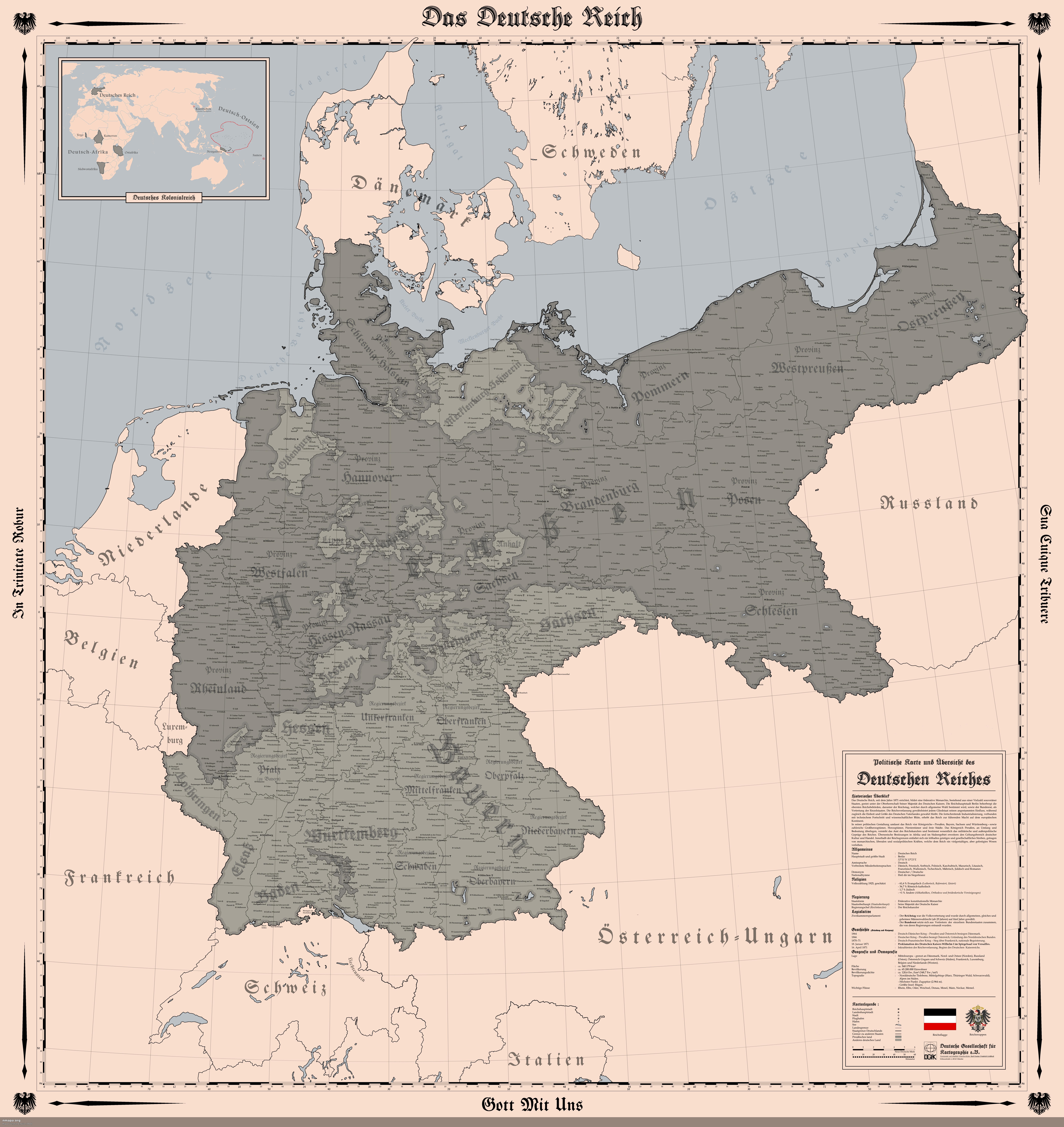
Map of the German Empire in 1914


David Chen
Data Visualization Specialist
David Chen is an expert in transforming complex geographic datasets into compelling visual narratives. He combines his background in computer science ...
Geographic Analysis
What This Map Shows
The "Map of the German Empire (1914)" provides a detailed representation of the territorial boundaries, cities, and infrastructure of Germany just before the onset of World War I. This year marked a crucial point in history, as the empire was at its zenith, showcasing a remarkable blend of various cultures and economic strengths across its regions. The map highlights over 2,500 cities, revealing not just the geographical layout, but also the intricate web of human settlements that defined the empire during this pivotal time.
Deep Dive into the German Empire’s Geography
The German Empire, established in 1871, was a complex amalgamation of various provinces, each contributing to a unique demographic and cultural landscape. Interestingly, the geography of the empire played a crucial role in its political and economic dynamics. Covering significant portions of Central Europe, the empire included not just what we now know as Germany, but also parts of modern-day Poland, France (specifically Alsace-Lorraine), Denmark, and even Belgium.
One of the most remarkable features of the German Empire was its urban development. Cities like Berlin, Munich, and Hamburg were not only population centers but also hubs of industry and commerce. For example, Berlin, the capital, was home to about 2 million residents, making it one of the largest cities in Europe at the time. The rapid industrialization of these urban areas was fueled by the empire's extensive rail network, which facilitated trade and movement across distances that would have otherwise been daunting.
Moreover, the map highlights the diverse landscapes, from the mountainous regions in the south, including the Bavarian Alps, to the flat plains of northern Germany. This variation in geography contributed to different economic activities; agriculture thrived in the fertile plains, while manufacturing flourished in urban centers. The Rhine River, one of the longest rivers in Europe, served as a vital artery for trade and transportation, connecting major cities and facilitating the movement of goods and people.
Interestingly, the empire also had distinct regional identities. For instance, the cultural influences in Bavaria differed significantly from those in Prussia. Bavarians were known for their traditions and distinct dialect, while Prussians were often associated with a more militaristic and industrial ethos. This distinction is evident in the map, which allows viewers to understand how geography shaped not only the physical landscape but also the cultural fabric of the empire.
Regional Analysis
Examining the map closely, we can discern various regional characteristics that defined the German Empire. In the north, regions like Schleswig-Holstein and Mecklenburg were primarily agricultural, with a lower population density compared to the bustling industrial hubs in the central and southern areas. The city of Hamburg, for instance, was a major port that leveraged its geographical position for trading and shipping, contrasting sharply with the more rural areas nearby.
Moving towards the south, Bavaria stands out with its picturesque landscapes and strong cultural identity. Cities like Munich were not just important for their economy but also served as cultural havens, reflecting the Bavarian spirit through festivals and traditions. The differences in urbanization levels are striking—cities in the south were often more densely populated and industrialized compared to their northern counterparts.
In contrast, the eastern regions, particularly Silesia and Posen, were marked by a mix of German and Polish populations, showcasing how the borders of the empire intersected with diverse ethnic groups. This diversity brought both richness and tension, as various national identities coexisted within the empire. The map serves as a visual testament to these intricate demographics, highlighting areas of potential conflict that would later become significant during World War I.
Significance and Impact
Understanding the geography of the German Empire in 1914 is crucial for grasping the complex geopolitical landscape of early 20th-century Europe. The map illustrates not only the boundaries of the empire but also the interconnectedness of its cities and regions. This interconnectedness would play a significant role in the empire's involvement in World War I, as the industrialized cities and extensive rail networks facilitated rapid mobilization of troops and resources.
Moreover, the demographics and economic disparities highlighted in the map have long-lasting implications. The cultural and ethnic diversity of the empire foreshadowed the conflicts that would arise in the wake of the war, shaping national identities that resonate in contemporary Europe. Today, as we reflect on the map of the German Empire, we can see how geography can influence political landscapes and societal structures, making it a vital area of study for understanding both past and present conflicts.
In conclusion, the "Map of the German Empire (1914)" is more than just a visual representation; it encapsulates the essence of a time and place marked by rich cultural tapestries and significant historical events. By examining the geography, demographics, and regional identities of the empire, we gain insight into the forces that shaped Europe and continue to influence it today.
Visualization Details
- Published
- August 5, 2025
- Views
- 166
Comments
Loading comments...