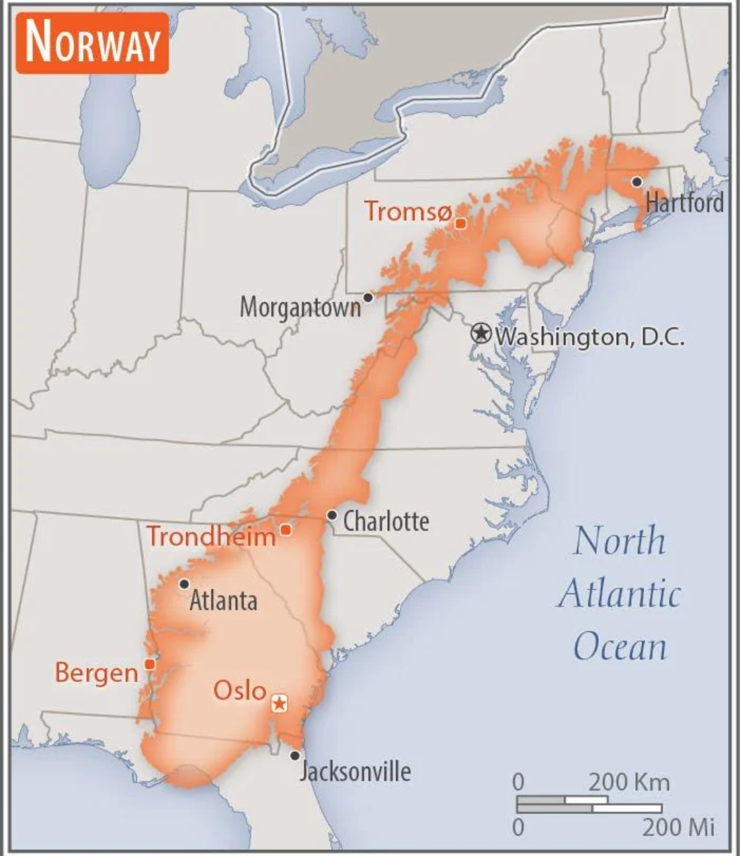
Norway Overlaid on the US Map

Alex Cartwright
Senior Cartographer & GIS Specialist
Alex Cartwright is a renowned cartographer and geographic information systems specialist with over 15 years of experience in spatial analysis and data...
Geographic Analysis
What This Map Shows
This intriguing map overlays the geographical boundaries of Norway onto the continental United States, providing a unique perspective on the sizes, shapes, and spatial relationships between these two regions. As you delve into this visualization, you’ll notice that Norway, known for its stunning fjords and rugged landscapes, fits into various parts of the U.S., allowing us to explore not just geographical similarities but also differences in physical features, climate, and cultural aspects.
Deep Dive into Norway's Geography
Norway's geography is characterized by its dramatic natural landscapes, including mountains, forests, and a long coastline dotted with countless islands and inlets. Stretching approximately 1,000 miles from north to south, Norway presents a diverse range of environments, from the arctic tundra of the north to the temperate climates in the south. The country is famous for its fjords, which are deep, narrow inlets created by glacial activity, with the most famous being the Geirangerfjord and Nærøyfjord, both UNESCO World Heritage Sites.
Interestingly, as Norway is overlaid on the U.S., you might find that its rugged terrain and coastal features can be compared to regions like the Pacific Northwest, especially Washington and Oregon, where you have similar mountainous landscapes and coastal inlets. However, the U.S. is much more diverse in terms of climate zones, ranging from the arid deserts of the Southwest to the humid subtropical regions in the Southeast.
The country is also home to significant rivers such as the Glomma, which is Norway’s longest river, flowing over 600 kilometers through the eastern part of the country. In the U.S., the Mississippi River system might be a suitable counterpart, not only in terms of length but also because of its importance for commerce and transportation. Another interesting aspect is Norway’s extensive forest cover, which constitutes about 38% of the country. This is somewhat comparable to areas in the U.S. like the Appalachian region, where dense forests are also a defining characteristic.
In terms of demographics, Norway has a population of approximately 5.4 million people, with Oslo as its capital. When we compare this to U.S. cities, Oslo's population is reminiscent of cities like Minneapolis or St. Paul, which also exhibit a blend of urban and natural environments.
Regional Analysis
When we look closer at the United States regions where Norway overlaps, it's fascinating to see the contrasts and similarities. For instance, overlaying Norway onto the northeastern part of the U.S. can help visualize the proximity of its population centers to natural features. The Norwegian fjords are reminiscent of the coastal landscapes found in Maine, where rocky coastlines meet the Atlantic Ocean.
As we shift westward, the overlay might cover areas like California and Oregon. Here, the mountainous terrain of Norway aligns with the Sierra Nevada and Cascade ranges, showcasing how these geographical features share a commonality in their ruggedness and beauty. Furthermore, if we consider the Arctic regions of Norway, like Finnmark, and overlay them onto northern Alaska, we can better understand the environmental conditions and indigenous cultures that thrive in these harsh climates.
Significance and Impact
Understanding this overlay has significant implications for how we think about geography, culture, and environmental challenges. For instance, Norway is often recognized for its commitment to sustainability and environmental stewardship. As climate change becomes a pressing global issue, seeing Norway’s geographical context against the U.S. backdrop can highlight how different regions approach environmental conservation.
Moreover, it allows us to reflect on the interconnectedness of communities across different geographical settings. Ever wondered how cultural practices, such as fishing or forestry, differ in these regions? The overlay can spark discussions on how geography influences lifestyle and economic activities.
Looking ahead, trends indicate that as climate change progresses, regions that share similar geographic traits—whether they are in Norway or the U.S.—will face common challenges, including rising sea levels, shifting ecosystems, and the need for sustainable resource management. Understanding these geographical relationships through maps can enhance our awareness and prepare us for future environmental shifts.
In conclusion, the map of Norway overlaid on the U.S. serves as a powerful visual tool, sparking curiosity about geography, culture, and the environments we inhabit. It invites us to contemplate how geographical features shape our lives, economies, and interactions with the natural world.
Visualization Details
- Published
- September 3, 2025
- Views
- 88
Comments
Loading comments...