Roman Empire Size Comparison Map with USA

David Chen
Data Visualization Specialist
David Chen is an expert in transforming complex geographic datasets into compelling visual narratives. He combines his background in computer science ...
Geographic Analysis
What This Map Shows
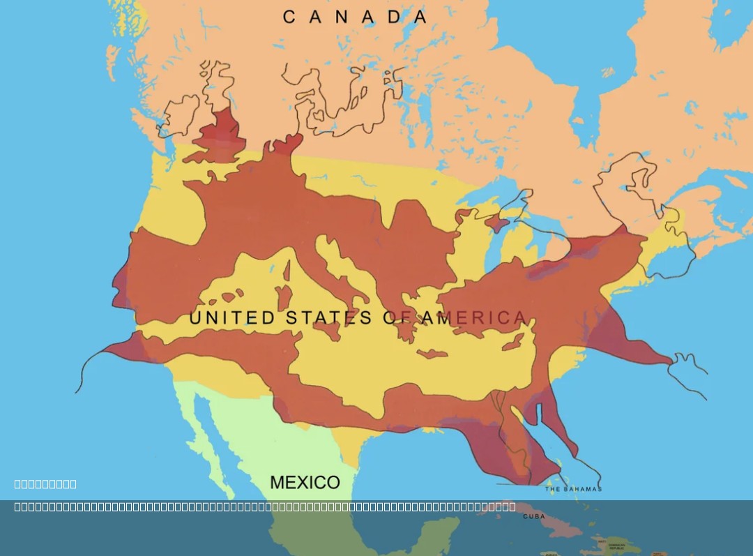
The map titled "The Size of the Roman Empire at Its Height Compared to the United States" visually compares the vast territories of the Roman Empire during its peak around 117 AD with the modern-day geographical boundaries of the United States. At its zenith, the Roman Empire stretched across three continents, encompassing diverse cultures, languages, and landscapes. This visualization allows us to appreciate the scale of Roman dominion and its geographical intricacies, providing a compelling context for understanding its historical significance.
Deep Dive into the Roman Empire
The Roman Empire, at its height, was not just a political entity; it was a complex tapestry of cultures and societies. Spanning approximately 5 million square kilometers (about 1.93 million square miles), it included territories that are now parts of over 30 modern countries, from Britain in the northwest to Egypt in the southeast. The empire’s expanse was characterized by a variety of geographical features, including mountains, rivers, and coastlines, which significantly influenced its administration and military strategies.
Interestingly, the empire was divided into provinces, each governed by a Roman official. This administrative structure was essential for managing such a large territory, allowing Rome to exert influence over diverse populations. The Pax Romana, a long period of relative peace and stability, facilitated trade and cultural exchange across these vast regions. Have you considered how the construction of roads and aqueducts, which were engineering marvels of the time, played a critical role in maintaining connectivity throughout the empire? These infrastructures were vital for economic growth, military movement, and the spread of ideas.
The Roman Empire's geography also impacted its military conquests. Natural barriers such as the Alps and rivers like the Rhine and Danube served both as defensive lines and as avenues for expansion. The strategic location of cities such as Rome, Alexandria, and Carthage enabled control over trade routes and resources, reinforcing the empire's wealth and power. The Mediterranean Sea, often referred to as the "Mare Nostrum" or "Our Sea" by the Romans, functioned as a crucial maritime highway for commerce and military operations, further solidifying Rome’s dominance.
Regional Analysis
When comparing the Roman Empire's vast territories shown in the map with the United States, several regional distinctions emerge. For instance, the western provinces, including Gaul (modern-day France) and Hispania (Spain), were culturally and economically vital, contributing significantly to the empire's resources and military manpower. In contrast, the eastern provinces, such as Judea and Asia Minor, were crucial for trade and cultural exchange, linking the empire to the rich civilizations of the Near East.
The U.S., while also a diverse nation, is characterized by its own unique geographic features and demographics. The expansive Midwest contrasts sharply with the mountainous terrain of the Rockies and the coastal regions of the East and West. Interestingly, while the Roman Empire was marked by a polyglot of languages and cultures, the U.S. predominantly speaks English, although it is home to numerous languages due to its immigrant population.
In terms of land area, the United States is significantly larger than the Roman Empire, covering about 9.8 million square kilometers (approximately 3.8 million square miles). However, the population density and urban development patterns differ markedly. The Roman cities were densely populated hubs of commerce and governance, while modern U.S. cities exhibit varied population densities influenced by suburbanization and urban sprawl.
Significance and Impact
Understanding the geographical scope of the Roman Empire and its comparison to the United States is essential for grasping the dynamics of historical and modern power. The Roman Empire laid the groundwork for many political and legal systems still in use today, influencing governance, architecture, and urban planning. Moreover, the legacy of Roman engineering can be seen in contemporary infrastructure, reflecting how geography continues to shape societies.
As we consider current global trends, the rise of new powers and the challenges of climate change present critical questions about territory, resources, and cultural exchange. Have you noticed how ancient empires like Rome inform our understanding of modern geopolitical strategies? The lessons learned from the Roman Empire—such as the importance of infrastructure and governance in managing vast territories—remain relevant today as nations navigate the complexities of globalization and international relations.
In conclusion, the map of the Roman Empire compared to the United States not only highlights the vastness of historical empires but also invites reflections on the continuous interplay of geography, culture, and power in shaping human history. The enduring influence of Rome continues to echo through time, reminding us of the intricate connections between geography and civilization.
Visualization Details
- Published
- August 4, 2025
- Views
- 240
Comments
Loading comments...