Land Cover Map of Romania

David Chen
Data Visualization Specialist
David Chen is an expert in transforming complex geographic datasets into compelling visual narratives. He combines his background in computer science ...
Geographic Analysis
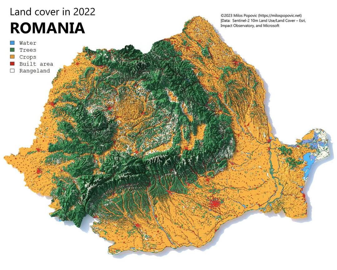
What This Map Shows
The "Land Cover Map of Romania" provides a detailed visualization of the various land use types across the country. This map categorizes land into several types such as forests, agricultural land, urban areas, wetlands, and more. By examining this map, we can gain insights into how Romania utilizes its land resources and the distribution of natural and developed spaces throughout the country.
Deep Dive into Land Cover in Romania
Land cover refers to the physical material at the surface of the earth, and in Romania, this encompasses a diverse array of ecosystems and human activities. The country is characterized by its rich biodiversity, largely due to its varied topography and climate. Approximately 27% of Romania is covered by forests, which are primarily found in the Carpathian Mountains and the Apuseni Mountains. These forests are home to a variety of species, including bears, wolves, and lynxes, making them not only vital for ecological balance but also significant for tourism and recreation.
Interestingly, Romania’s agricultural land occupies about 40% of its total area. This includes arable land, pastures, and meadows, mainly located in the fertile plains of the Danube River Basin and Transylvania. The country is known for its agricultural output, particularly in cereals, fruits, and vegetables, contributing significantly to both domestic consumption and export.
Urban areas make up around 10% of Romania's land cover. The capital, Bucharest, is the largest urban center, characterized by a blend of historical architecture and modern developments. Other notable cities like Cluj-Napoca, Timișoara, and Iași also display a mix of urban sprawl and green spaces, reflecting the country's ongoing urbanization trends.
Wetlands, though covering a smaller percentage of land, are crucial for biodiversity and water management. The Danube Delta, a UNESCO World Heritage site, is one of the most significant wetland areas, providing essential habitat for numerous bird species and playing a critical role in flood control and water purification.
The variety of land cover in Romania is not just a matter of aesthetic beauty; it plays a fundamental role in the country’s economy, culture, and environment. Understanding these land types can help inform policies related to sustainable land use, conservation efforts, and urban planning.
Regional Analysis
Examining the land cover map reveals significant regional variations that are shaped by geography, climate, and human activity. For instance, the mountainous regions in central Romania possess dense forests, while the lowland areas, particularly in the south and east, are predominantly agricultural. The Transylvania region, surrounded by the Carpathian Mountains, is known for its mixed land use, where agriculture coexists with forested areas.
In the Dobrogea region, located by the Black Sea, the land cover is distinctly different. Here, you’ll find a combination of agricultural land and coastal ecosystems, which are vital for both biodiversity and tourism. The contrast between the lush green hills of Transylvania and the arid plains of Dobrogea illustrates the diverse ecological zones within Romania.
Urbanization is a significant factor affecting land cover in Romania, particularly in the metropolitan areas. For example, Bucharest has expanded rapidly, resulting in a reduction of green spaces and agricultural land. This urban sprawl poses challenges regarding environmental sustainability and necessitates strategic planning to balance urban growth with ecological preservation.
Significance and Impact
Understanding land cover in Romania is essential for various reasons. It informs environmental policies, guides agricultural practices, and influences urban planning. As Romania navigates the challenges of climate change, sustainable land management becomes increasingly important. The country is facing pressures from agricultural expansion, urban development, and climate variability, all of which can impact its rich biodiversity.
Moreover, the land cover map serves as a valuable tool for researchers and policymakers to assess the impact of human activities on natural habitats. For instance, the ongoing deforestation in some regions raises concerns about habitat loss and species extinction. Addressing these issues requires a comprehensive understanding of land use patterns and their implications for both the environment and the economy.
Looking ahead, Romania's commitment to sustainable development will shape its land cover in the future. Strategies aimed at preserving forests, protecting wetlands, and promoting sustainable agriculture will play a pivotal role in maintaining the country's ecological health. Overall, the land cover of Romania is not just a reflection of its physical landscape; it is a dynamic interplay of nature and human influence, requiring careful stewardship for generations to come.
Visualization Details
- Published
- October 21, 2025
- Views
- 18
Comments
Loading comments...