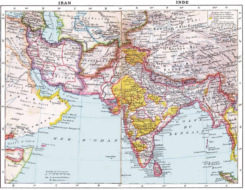
1907 French Colonial Map of South Asia

Marcus Rodriguez
Historical Geography Expert
Marcus Rodriguez specializes in historical cartography and geographic data analysis. With a background in both history and geography, he brings unique...
Geographic Analysis
What This Map Shows
The 1907 French map of South Asia offers a detailed representation of the region during a pivotal time in its history. This map not only outlines the political boundaries and colonial territories of the time but also highlights significant geographic features such as rivers, mountain ranges, and cities. It serves as a snapshot of South Asia in the early 20th century, detailing the influence of colonial powers, particularly the French and British, on the landscape and demography of the area.
Deep Dive into Colonial Influences in South Asia
Interestingly, South Asia has a rich tapestry of colonial history that has shaped its modern landscape. The late 19th and early 20th centuries were marked by significant foreign influence, primarily from the British Empire and to a lesser extent, the French. This map reflects those influences, showing not only the territorial claims but also the cultural and economic ramifications of colonial rule.
One key aspect to consider is how colonial powers altered the existing administrative structures. Take, for example, the British Raj, which governed much of India from 1858 until independence in 1947. The map illustrates the division of territories into provinces and districts, which were often designed for efficient resource extraction rather than local governance. The introduction of a railway system, better depicted in this map, was primarily aimed at transporting raw materials to ports for export, effectively integrating the Indian economy into the global market.
Moreover, the demographic changes brought about by colonial policies are noteworthy. Cities like Calcutta (now Kolkata) and Bombay (now Mumbai) experienced rapid urbanization due to the influx of migrants seeking employment in new industries. This map captures the burgeoning urban centers and the spatial distribution of populations, with some areas experiencing significant growth while others remained largely rural.
The impact on agriculture also cannot be overlooked. Colonial practices transformed traditional farming methods, introducing cash crops like tea, jute, and indigo, which were in high demand in Europe. As depicted in the map, regions such as Bengal became agricultural hubs, drastically changing local economies and social structures. However, these changes often led to ecological degradation, something that is still being addressed today.
Regional Analysis
Examining the map region by region reveals stark contrasts in colonial impact. For instance, in the northern regions, notably Punjab and the foothills of the Himalayas, the British implemented agricultural policies that fueled economic growth, but also led to social tensions, especially during the partition of India. Interestingly, the fertile plains of this area are depicted prominently on the map, showcasing their agricultural significance.
In contrast, southern territories like Tamil Nadu and Kerala present a different picture. Here, French colonial influence was more pronounced in the coastal areas, particularly in Puducherry, which remains a unique cultural enclave to this day. The map highlights the mixed heritage resulting from French colonialism, with influences evident in language, cuisine, and architecture.
Moving to the eastern regions, the map illustrates the significant role of trade routes and maritime access. Coastal cities such as Chittagong served as vital ports for trade, connecting South Asia with Southeast Asia and beyond. The historical significance of these trade routes is still felt today, as they continue to be crucial for regional commerce.
Significance and Impact
Understanding the themes presented in the 1907 French map of South Asia is essential for grasping the complexities of the region's past and its implications for the future. The legacies of colonialism are still evident in modern socio-economic conditions and political boundaries. Ever wondered why certain regions experience ongoing unrest or economic challenges? The answers often lie in the historical contexts illustrated in maps like this one.
What’s fascinating is how this map serves not only as a historical document but also as a tool for contemporary analysis. As South Asia navigates globalization and regional cooperation, the historical divisions highlighted in the map can provide insights into current geopolitical dynamics. For instance, the ongoing discussions regarding trade agreements and regional partnerships often hark back to the colonial boundaries that defined economic interactions.
In conclusion, this 1907 French map of South Asia is more than just a visual representation; it encapsulates a significant period that shaped the identities, economies, and geopolitics of the region. By examining its details, we can better appreciate the intricate connections between history and modernity, making it a vital resource for anyone interested in the geography of South Asia.
Visualization Details
- Published
- October 10, 2025
- Views
- 2
Comments
Loading comments...