Geographical Map of the Indian Subcontinent

David Chen
Data Visualization Specialist
David Chen is an expert in transforming complex geographic datasets into compelling visual narratives. He combines his background in computer science ...
Geographic Analysis
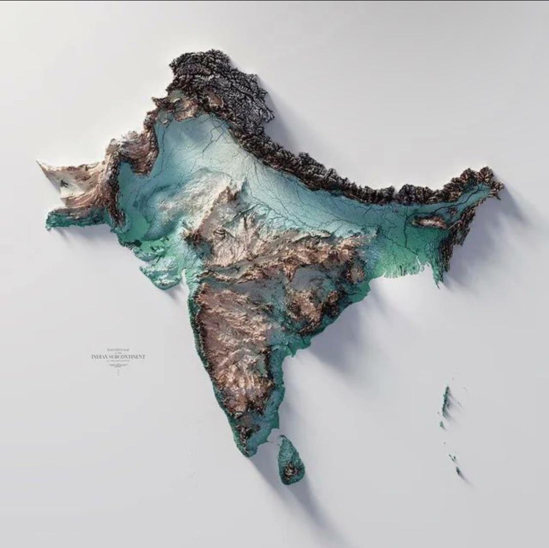
What This Map Shows\nThis geographical visualization of the Indian subcontinent showcases the diverse landscapes, political boundaries, and significant geographical features of the region. The map highlights not only the countries that comprise the subcontinent—namely India, Pakistan, Bangladesh, Nepal, Bhutan, Sri Lanka, and the Maldives—but also rivers, mountain ranges, and other vital geographical elements. By examining this map, one can understand the spatial relationships between these countries and their features, which play a crucial role in shaping their cultures, economies, and environments.
Deep Dive into the Indian Subcontinent's Geography\nThe Indian subcontinent is a remarkable area characterized by its complex geography, which includes a variety of landforms such as mountains, plains, plateaus, and coastal regions. The Himalayas, the highest mountain range in the world, form a natural border between India and its northern neighbors. This majestic range not only influences the climate but also affects the water supply for millions who live in its shadow. The Ganges River, one of the most significant rivers in India, is a lifeline for agriculture and is considered sacred by many.
The Indo-Gangetic Plain, one of the most densely populated regions in the world, is another striking feature of the subcontinent. This fertile area supports a large agricultural base due to its rich alluvial soil and access to major rivers like the Ganges and Yamuna. Interestingly, the population density in this region is among the highest globally, leading to bustling cities and towns that are vital economic hubs.
On the southern tip of the subcontinent, the Deccan Plateau rises, showcasing a different geological structure. This area is marked by volcanic rock and is home to the Western and Eastern Ghats, which are critical for biodiversity. The unique climate patterns created by these mountains contribute to the region's rich flora and fauna, making it a hotspot for conservation efforts. Have you ever wondered how these varying topographies influence local cultures? For instance, communities living in the mountains often have distinct lifestyles compared to those in the plains, shaped by their environment.
Furthermore, the coastal regions along the Arabian Sea and Bay of Bengal are significant for trade and tourism. The cities of Mumbai and Chennai, located on these coasts, are vital economic centers, reflecting the importance of maritime trade in the subcontinent's history and development.
Regional Analysis\nWhen examining the Indian subcontinent through the lens of its geography, it's essential to consider the distinct regions: the northern mountainous region, the fertile plains, the central plateau, and the southern coastal areas.
In the north, states like Jammu and Kashmir and Himachal Pradesh are renowned for their breathtaking landscapes and tourism, but they also face challenges due to their mountainous terrain, such as accessibility and climate-induced issues. In contrast, states like Uttar Pradesh and Bihar in the Indo-Gangetic Plain have high agricultural productivity, yet they grapple with urbanization and population pressure. Interestingly, while both regions are crucial to the country’s economy, their challenges and opportunities vary significantly.
Moving south, the Deccan Plateau presents a different scenario. States like Karnataka and Maharashtra are not only rich in minerals but also have a booming tech industry, particularly in cities like Bengaluru. This regional disparity illustrates how geography can shape economic activities and development trajectories. Conversely, the coastal states of Kerala and Tamil Nadu are known for their agriculture and fishing industries, which significantly contribute to their local economies.
Significance and Impact\nUnderstanding the geography of the Indian subcontinent is vital for several reasons. Firstly, it helps in disaster management, especially in regions prone to floods and earthquakes. The Himalayas, for example, are seismically active, and knowing this can guide infrastructural development and emergency preparedness.
Moreover, geography influences trade routes, resource distribution, and even cultural exchanges. As global demand for resources increases, the significance of the subcontinent's natural resources—such as water from the major rivers or minerals from the Deccan Plateau—becomes even more pronounced.
Looking ahead, the impact of climate change on the geography of the Indian subcontinent cannot be overstated. Rising sea levels threaten coastal communities, while changes in rainfall patterns can affect agriculture in the Indo-Gangetic Plain. Addressing these challenges requires comprehensive geographical knowledge and planning. The future of the region will heavily depend on how effectively it can adapt to these environmental changes, making the study of its geography more critical than ever.
In conclusion, the geographical map of the Indian subcontinent serves as more than just a visual representation; it encapsulates the interplay between physical landscapes, human settlements, and cultural dynamics, illustrating a region that is vibrant, complex, and in constant evolution.
Visualization Details
- Published
- October 7, 2025
- Views
- 42
Comments
Loading comments...