Population Density Map of Europe

David Chen
Data Visualization Specialist
David Chen is an expert in transforming complex geographic datasets into compelling visual narratives. He combines his background in computer science ...
Geographic Analysis
What This Map Shows
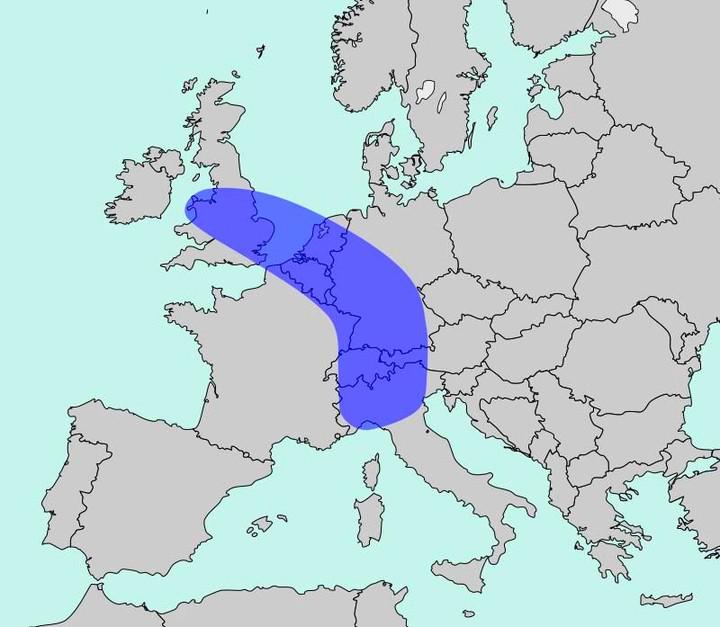
The map titled "The Blue Banana" visualizes Europe’s most densely populated corridor, home to approximately 111 million people. This geographical corridor stretches from the northern region of England, through the Benelux countries, and down to northern Italy. It highlights urban centers and major metropolitan areas where the population density is highest, showcasing the significant concentration of people in this particular area. However, beyond just showing numbers, the map serves as a gateway to understanding the underlying dynamics of urbanization, migration, and economic development in Europe.
Deep Dive into Population Density
Population density is a crucial aspect of geography that reveals much about human settlement and activity. In the case of the Blue Banana, the concentration of population isn't just a phenomenon; it's a result of complex historical, economic, and social factors. The corridor is home to some of Europe’s largest cities, including London, Brussels, Amsterdam, Frankfurt, and Milan. These cities are not only densely populated but also serve as hubs for commerce, culture, and innovation.
What's fascinating is how urbanization has shaped this corridor over the decades. The post-World War II economic boom in Europe led to heightened migration from rural areas to urban centers, as people sought jobs and better living standards. This trend has continued, with urban areas expanding and attracting even more residents. As of 2023, urban areas in the Blue Banana are characterized by high levels of infrastructure development, including transportation networks, educational institutions, and healthcare services.
Interestingly, the population density in this corridor is not uniformly distributed. For instance, while London boasts a staggering density of around 5,500 people per square kilometer, other regions within the Blue Banana, like parts of northern France, have significantly lower densities. This variation can be attributed to factors such as economic opportunities, lifestyle preferences, and historical migration patterns.
Moreover, demographic trends in the Blue Banana are also noteworthy. The region is becoming increasingly diverse due to immigration, adding layers of cultural richness but also challenges related to integration and social cohesion. According to recent statistics, cities like Brussels and Amsterdam have seen substantial increases in their immigrant populations, contributing to a multicultural landscape that influences everything from cuisine to festivals.
Regional Analysis
Examining the Blue Banana on a regional basis reveals intriguing contrasts. For example, the UK segment, particularly London, stands out with its economic prowess and cultural significance. The city is a global financial center and attracts talent from around the world, making it a prime example of urban density’s benefits.
In contrast, the Benelux region, comprising Belgium, the Netherlands, and Luxembourg, presents a different picture. Cities like Brussels and Amsterdam are known for their progressive policies and high quality of life, which draw people in. However, the population density in Belgium is complicated by linguistic divides, with Flemish and Walloon regions experiencing different social dynamics and growth rates.
Moving southward into Germany, cities like Frankfurt and Munich contribute significantly to the Blue Banana’s population density. Frankfurt, known as the financial capital of Germany, has a high density due to its economic opportunities and excellent transportation links, including one of Europe’s busiest airports. Munich, on the other hand, is recognized for its blend of technology and tradition, attracting a younger demographic and families seeking a high quality of life.
Finally, the Italian segment of the Blue Banana, especially Milan, showcases a different aspect of density. Milan is a major fashion and design hub, drawing in both residents and tourists. However, it also faces challenges like traffic congestion and housing shortages, common issues in highly populated urban areas.
Significance and Impact
Understanding the population density in the Blue Banana is vital for several reasons. It has implications for urban planning, resource allocation, and environmental sustainability. As cities continue to grow, local governments must address the challenges of housing, transportation, and public services to ensure a high quality of life for residents.
Furthermore, economic disparities within the corridor can lead to social tensions and inequality. Regions that fall behind in economic development may struggle to provide adequate services, leading to a cycle of poverty and urban decay. This is particularly relevant in less dense areas of the Blue Banana, where opportunities may not be as abundant as in major cities.
Looking ahead, the Blue Banana's population dynamics will likely continue to evolve. Factors like climate change, economic shifts, and technological advancements will play significant roles in shaping migration patterns and urban growth. As we monitor these trends, it’s essential to consider how to create sustainable urban environments that can accommodate growing populations while preserving the quality of life for all residents. Thus, the Blue Banana is not just a map of population density; it’s a reflection of the intricate tapestry of life, economy, and culture in Europe today.
Visualization Details
- Published
- October 7, 2025
- Views
- 68
Comments
Loading comments...