Japanese Topographical Map by Inō Tadataka

Marcus Rodriguez
Historical Geography Expert
Marcus Rodriguez specializes in historical cartography and geographic data analysis. With a background in both history and geography, he brings unique...
Geographic Analysis
What This Map Shows
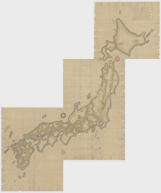
The map created by Inō Tadataka in 1821 represents a detailed topographical outline of Japan, showcasing the country's mountains, rivers, and coastal features. Tadataka intricately measured distances across various terrains on foot, providing a remarkable representation of Japan's geography during the Edo period. This meticulous work not only serves as a historical artifact but also lays the groundwork for modern cartography in Japan, presenting a blend of artistry and precision that reflects the landscape's complexity.
Deep Dive into Japan's Geography
Japan, an archipelago located in East Asia, is characterized by its diverse geographical features. The country comprises four main islands—Honshu, Hokkaido, Kyushu, and Shikoku—along with numerous smaller islands. This unique geography influences not just the physical landscape but also the climate, culture, and settlement patterns of its inhabitants.
One of the most notable features on the map is Japan's mountainous terrain, which accounts for about 73% of the nation's land area. The Japanese Alps, including the Northern and Southern ranges, are prominent, with peaks such as Mount Fuji standing as iconic symbols of the nation. Interestingly, these mountains are not merely scenic; they dictate weather patterns and serve as natural barriers affecting regional climates. For instance, the windward side of these mountains receives abundant rainfall, fostering lush forests, while the leeward side often experiences drier conditions.
Furthermore, Japan's river systems are equally compelling. Major rivers such as the Shinano and the Tone are depicted on Tadataka's map, illustrating their courses and tributaries. These rivers have historically been vital for agriculture, transportation, and fishing, shaping the local economies. The Shinano River, for example, is the longest river in Japan, flowing through mountainous regions and providing essential irrigation for rice cultivation, which is a staple food in Japanese cuisine.
Interestingly, Japan's geographical features have also influenced its seismic activity. Situated along the Pacific Ring of Fire, the country is prone to earthquakes and volcanic eruptions. The map provides a historical context to these natural phenomena, showing how certain areas are more vulnerable than others. The relationship between geography and natural disasters is a significant consideration for urban planners and policymakers today.
Regional Analysis
Examining the map regionally reveals diverse geographic characteristics across Japan. For example, the Kanto region, home to Tokyo, is relatively flat compared to the mountainous terrain of the Chubu region. This flatness has facilitated urban development and industrial growth, making it one of Japan’s most populous areas. Conversely, the mountainous regions of Nagano and Gifu have smaller populations, with communities often relying on agriculture and tourism.
In contrast, the northern island of Hokkaido is known for its unique landscapes, including vast forests and fertile plains. The map indicates the significance of rivers in Hokkaido, such as the Tokachi River, which supports agriculture in this colder climate. The island’s geography also leads to a distinct climate, with heavy snowfall in winter, attracting tourists for skiing and winter sports.
The southern island of Kyushu presents another fascinating contrast. It is volcanic in nature, hosting active volcanoes like Mount Aso, which significantly shapes its landscape and agriculture. The fertile volcanic soil supports a robust agricultural sector, particularly in rice and citrus fruits. This geographical diversity is crucial for understanding Japan's regional cultures and economies.
Significance and Impact
Understanding Japan's geography, as illustrated by Tadataka's map, holds significant importance not only from a historical perspective but also in contemporary contexts. The intricate relationship between landforms, climate, and human activities has shaped Japan's development through the centuries. Today, this map serves as a reference point for discussions around environmental sustainability, urban planning, and disaster preparedness.
What's fascinating is how Tadataka's efforts resonate with modern cartographic practices. His dedication to measuring distances on foot mirrors contemporary geographic information systems (GIS) that rely on precise data collection. As Japan faces challenges like climate change and urban sprawl, the insights derived from such historical maps can guide future policies and strategies.
In conclusion, Inō Tadataka's 1821 map is not merely a historical document; it encapsulates the essence of Japan's topography and its implications for human activity, culture, and safety. By studying this map, we gain valuable insights into how geography shapes societies and the ongoing need to adapt to our environment.
Visualization Details
- Published
- September 27, 2025
- Views
- 36
Comments
Loading comments...