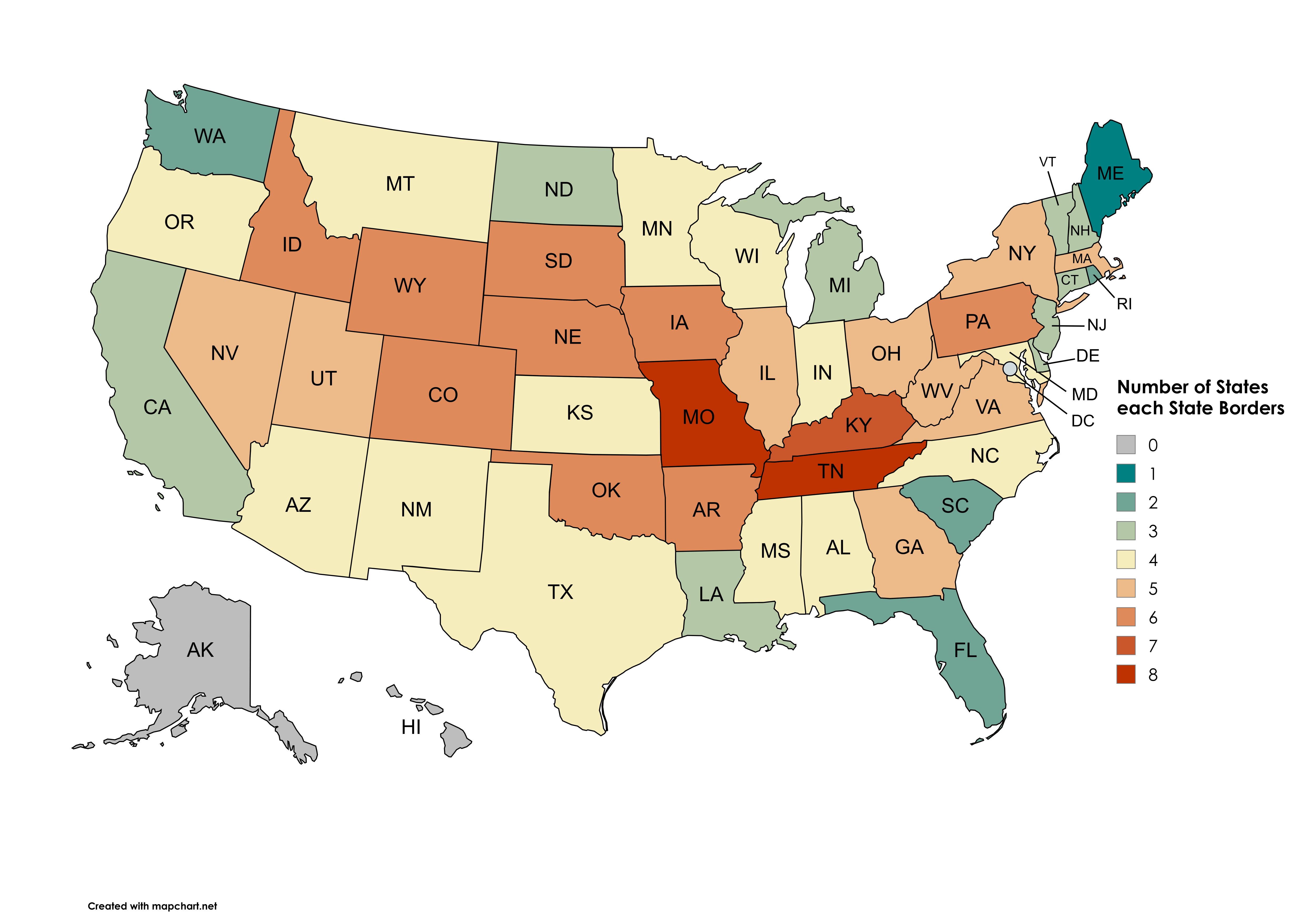
Map of States Each State Borders

Marcus Rodriguez
Historical Geography Expert
Marcus Rodriguez specializes in historical cartography and geographic data analysis. With a background in both history and geography, he brings unique...
Geographic Analysis
What This Map Shows
This visualization illustrates the number of states each U.S. state borders, excluding Washington D.C., water borders, and the diagonal corner of the Four Corners region. At first glance, it might seem like a straightforward depiction of state lines, but it unveils a deeper understanding of the geographical relationships between states, highlighting how interconnected they truly are.
Deep Dive into State Borders
The borders between states are more than just lines on a map; they represent historical decisions, political compromises, and geographical realities. Each state has its own unique set of borders that can influence everything from trade and transportation to cultural exchanges and environmental management. For instance, states like Tennessee and Missouri border eight other states, making them significant hubs of movement and interaction.
What's fascinating is how these borders can shape a state's identity. Take Texas, for example, with its long borders with four states: New Mexico, Oklahoma, Arkansas, and Louisiana. The cultural influences from these neighboring states can be seen in Texas's cuisine, music, and festivals.
Interestingly, not every state has an equal number of neighbors. Alaska, despite being the largest state by area, only shares a border with Canada and has no contiguous states to connect with. This geographic isolation has profound implications on everything from trade routes to cultural exchanges.
Moreover, the history of how these borders were drawn often reflects the tumultuous nature of American history. For example, the creation of the state of West Virginia during the Civil War era was a direct result of differing regional loyalties within Virginia. Understanding these historical contexts helps to explain current political and social dynamics.
In terms of sheer numbers, states like Colorado, which borders seven others, play a crucial role in regional cooperation. The geographical layout encourages collaboration on shared resources such as water and energy. This interconnectedness can also be seen in transportation networks, where states work together to maintain highways and railways that cross borders.
Regional Analysis
When we look at the map regionally, the variations in the number of bordering states are striking. The Northeast, for instance, boasts a high density of states with many borders. States like Pennsylvania and New York have a complex array of neighboring states, leading to a rich tapestry of cultural and economic interactions.
In contrast, the West presents a different picture. States like Wyoming and Montana have fewer neighbors, which can result in unique challenges and opportunities. For example, Wyoming, with only six neighboring states, has a more homogenous population and economy, while states with more borders tend to have a greater diversity of influences.
The Midwest showcases its own dynamics, with states like Illinois and Indiana bordering multiple states and serving as critical transportation hubs. The Great Lakes region further complicates this map, as waterways play a significant role in trade and transportation, despite not being counted in this visualization.
Significance and Impact
Understanding the number of borders each state has is significant for several reasons. Firstly, it impacts political representation. States with more borders often have a broader range of interests to consider in policymaking, leading to more complex political landscapes. This affects everything from Congress to local governance.
Secondly, the economic implications are substantial. States with high connectivity can facilitate trade and economic cooperation, which is crucial for industries such as agriculture and manufacturing. For example, the Midwest, known as the nation’s breadbasket, relies heavily on its interconnected states to transport goods efficiently.
Real-world implications extend to environmental management as well. States that share borders must collaborate on conservation efforts, especially for shared natural resources like rivers and forests. The challenges of climate change have made this collaboration even more critical as states navigate shared threats.
In conclusion, the topic of state borders goes far beyond mere geography. It intertwines with history, culture, economy, and environmental management, making it an essential area of study for anyone interested in understanding the United States. As we continue to observe these dynamics, it becomes clear that the lines on a map are just the beginning of a much larger story.
Visualization Details
- Published
- September 26, 2025
- Views
- 48
Comments
Loading comments...