Official Map of the Argentine Republic

Alex Cartwright
Senior Cartographer & GIS Specialist
Alex Cartwright is a renowned cartographer and geographic information systems specialist with over 15 years of experience in spatial analysis and data...
Geographic Analysis
What This Map Shows
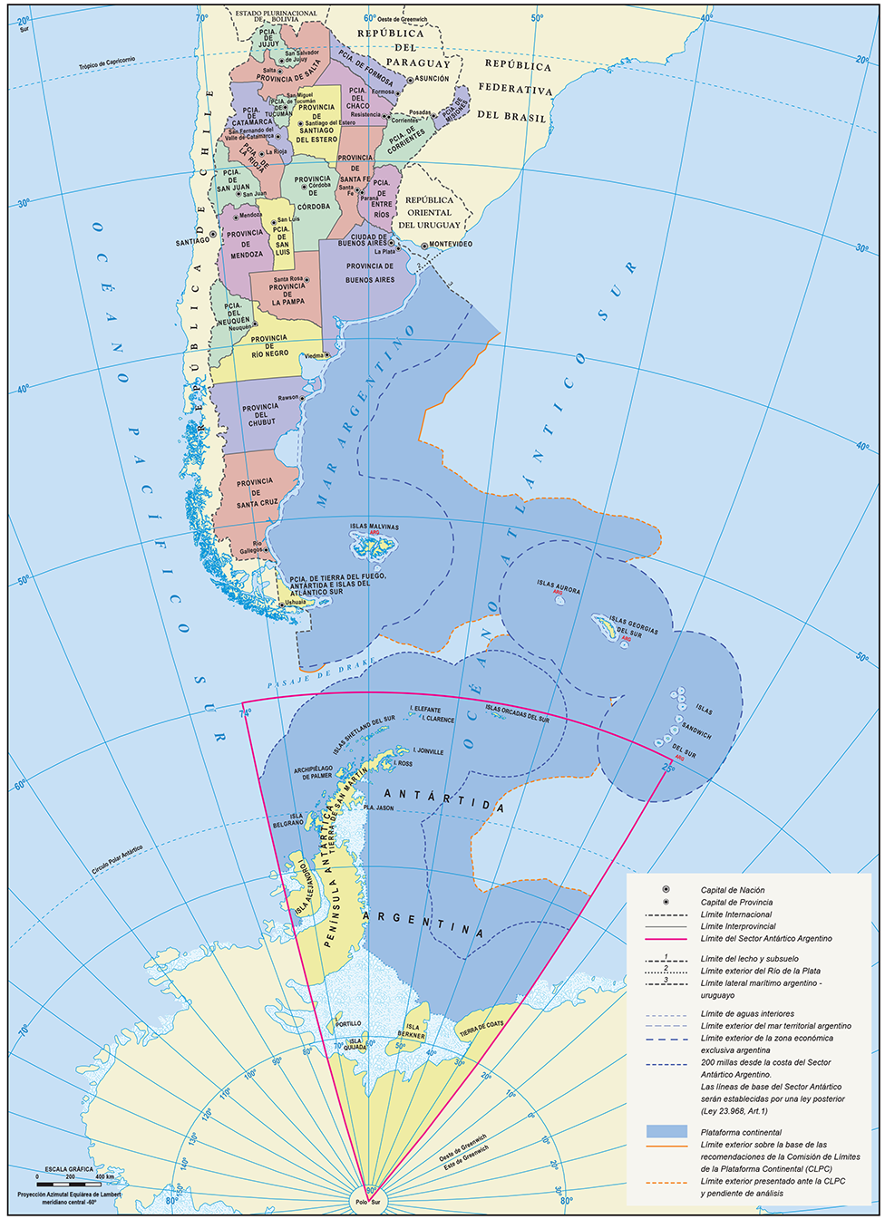
The official map of the Argentine Republic provides a comprehensive representation of the country's geographical features, political boundaries, and administrative divisions. It illustrates not only the vast landscape of Argentina but also highlights key cities, provinces, and natural landmarks that define this South American nation. The map serves as a valuable tool for understanding the complex geography of Argentina, which is characterized by its diverse environments ranging from the Andes mountains in the west to the expansive Pampas grasslands in the central region.
Deep Dive into Argentina's Geography
Argentina is the eighth largest country in the world, covering approximately 2.78 million square kilometers. The geographical diversity is remarkable, with distinct regions that each contribute to the country’s unique identity. The Andes mountain range, which forms the western border with Chile, is not only the longest continental mountain range in the world but also home to Aconcagua, the highest peak in the Americas at 6,961 meters (22,838 feet). This majestic range influences the climate and ecology of the western provinces, creating rain shadow effects that result in a stark contrast with the eastern regions.
Interestingly, the eastern part of Argentina is dominated by the Pampas, a fertile lowland that is crucial for agriculture. The Pampas is known for its rich soil, making it one of the most productive agricultural zones in the world. This area supports the country's beef industry, which is famous for producing some of the highest quality meat. Have you ever wondered why Argentina is synonymous with steak? The answer lies in the vast ranches, or "estancias," that dot the landscape, showcasing the significance of agriculture to the nation’s economy.
Moreover, Argentina’s varied climate ranges from the subtropical north, characterized by humid weather and lush vegetation, to the arid regions of Patagonia in the south, where one can find striking landscapes like the Perito Moreno Glacier. This geographical diversity not only supports a wide array of flora and fauna but also attracts millions of tourists each year, eager to experience Argentina's natural beauty.
Regional Analysis
Examining the official map, we can break down Argentina into several key regions: the Northwest, the Northeast, the Central Pampas, the Cuyo region, the Patagonia region, and the Buenos Aires metropolitan area.
1. **Northwest (NOA)**: This area is known for its indigenous cultures and rich history. Provinces such as Salta and Jujuy are famous for their stunning landscapes, including the Quebrada de Humahuaca, a UNESCO World Heritage site known for its colorful hills.
2. **Northeast (NEA)**: This region, which includes Misiones and Corrientes, is marked by the Paraná River and the Iguazú Falls, one of the most spectacular natural wonders in the world. The subtropical climate here supports a biodiverse rainforest ecosystem.
3. **Central Pampas**: The heart of Argentina's agricultural production, this region is home to cities like Córdoba and Santa Fe. The map reveals a network of rural roads and railways that facilitate the transport of goods and highlight the importance of agribusiness.
4. **Cuyo**: Known for its wine production, especially Malbec, Mendoza is located in this arid region. The Andes provide water through meltwater irrigation, making this region a vital economic area for viticulture.
5. **Patagonia**: Spanning the southernmost parts of Argentina, Patagonia is less densely populated, with vast stretches of wilderness. The official map shows a variety of national parks here, including Los Glaciares and Torres del Paine, which are critical for conservation efforts.
6. **Buenos Aires**: The capital city, Buenos Aires, is depicted prominently on the map. As the largest city in Argentina, it serves as the cultural and economic hub, hosting a diverse population and a vibrant arts scene.
Significance and Impact
Understanding the geography of Argentina is essential not only for navigating its physical landscape but also for grasping its socio-economic dynamics. The geographic distribution of resources affects trade, agriculture, and tourism, making it a crucial aspect of national development.
The current trend of urbanization in Argentina, particularly in Buenos Aires, raises questions about sustainable development. As people flock to cities for better opportunities, the pressure on urban infrastructure increases, leading to challenges such as housing shortages and environmental degradation. Looking forward, climate change poses significant risks to Argentina's varied ecosystems, particularly in the agricultural sectors that are vital to the economy.
Moreover, the map is a reminder of the rich cultural tapestry that defines Argentina, shaped by its geography. From the indigenous communities in the north to the European influences in the south, the geographical features have played a pivotal role in shaping the nation’s identity.
In conclusion, the official map of the Argentine Republic not only serves as a guide to the country’s geographical layout but also reveals the intricate relationship between the land and its people. By understanding this connection, we gain insights into the challenges and opportunities that lie ahead for Argentina in a rapidly changing world.
Visualization Details
- Published
- September 10, 2025
- Views
- 66
Comments
Loading comments...