Annual Precipitation Map of Germany 2024

Marcus Rodriguez
Historical Geography Expert
Marcus Rodriguez specializes in historical cartography and geographic data analysis. With a background in both history and geography, he brings unique...
Geographic Analysis
What This Map Shows
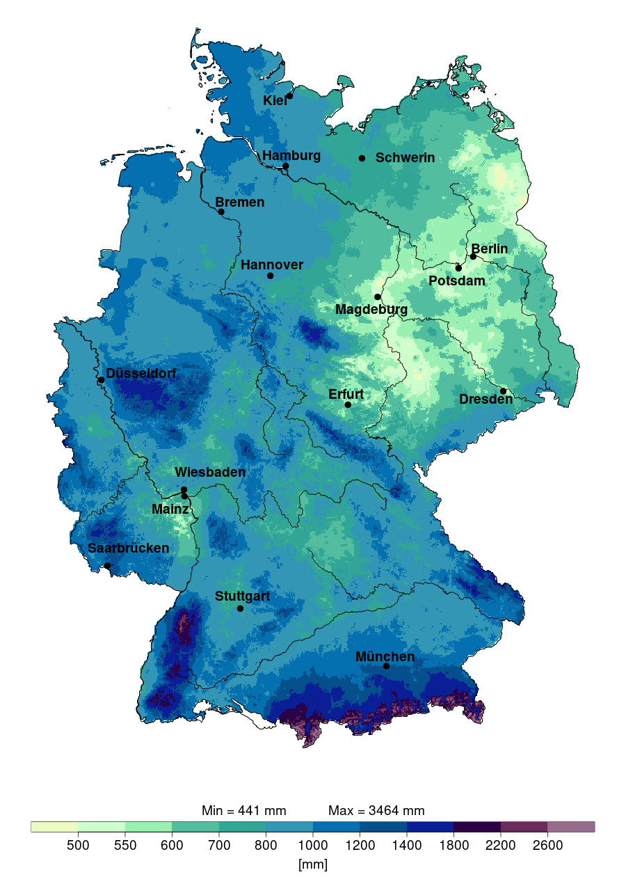
The "Annual Precipitation in Germany in 2024" map provides a detailed visualization of the expected rainfall distribution across different regions of Germany. Covering the entire country, this map outlines the varying levels of precipitation, highlighting areas that are likely to experience high rainfall compared to those that will see less. Understanding these patterns is crucial for assessing water resources, agricultural planning, and preparing for potential flooding events.
Deep Dive into Precipitation Patterns in Germany
Precipitation is a vital component of any country's climate system, influencing everything from agriculture to urban planning. In Germany, annual precipitation varies significantly due to geographical and meteorological factors. The distribution of rainfall is shaped by the country's varied topography, which includes mountains, hills, and plains.
Interestingly, western and southern parts of Germany, particularly the regions near the Rhine and the Alps, tend to receive higher annual precipitation. For example, places like Freiburg and Stuttgart can see upwards of 1,200 mm of rainfall annually. In contrast, the eastern parts, such as Brandenburg and parts of Saxony, receive considerably less, often around 500 mm to 600 mm. This stark difference can impact local ecosystems, agriculture, and even tourism.
The precipitation types in Germany also vary. Most rainfall occurs in the form of steady, light rain, but it can also manifest as heavy downpours, particularly during the summer months. This seasonal variability leads to a rich diversity of natural landscapes, from lush green forests in wetter areas to drier, more arid regions in the east.
One of the fascinating phenomena in Germany is the influence of the North Atlantic Oscillation (NAO) on precipitation patterns. This climatic pattern can lead to wetter winters and drier summers under certain conditions, which directly affects agricultural yields. For farmers, knowing the expected precipitation levels can help in making informed decisions about crop selection and irrigation practices.
Regional Analysis
Looking at the map's regional highlights, we can see that the southwest, particularly the Black Forest region, experiences some of the highest levels of precipitation due to its elevation and proximity to moisture-laden winds from the Atlantic. In contrast, the northern coastal areas, while still receiving significant rainfall, do not see the extremes found in the south. This difference can be attributed to the orographic lift, where moist air is forced upwards by the mountains, cooling and releasing moisture as rain.
Central regions, including cities like Frankfurt and Wiesbaden, typically enjoy a moderate climate with balanced precipitation levels, making them suitable for a diverse range of agricultural practices. However, the eastern states, known for their more continental climate, show a decline in rainfall, which can pose challenges for water supply and agriculture.
Moreover, urban areas like Berlin and Hamburg have unique precipitation patterns due to the urban heat island effect, which can lead to localized weather phenomena. Urban planning must consider these factors when designing drainage systems and managing water resources.
Significance and Impact
Understanding precipitation patterns in Germany is not just a matter of environmental science; it has real-world implications. As climate change continues to alter weather patterns, the projections on this map will become increasingly crucial for various sectors. For instance, farmers need to adapt to changing rainfall patterns to ensure food security. Urban planners must consider the risk of flooding as heavy rains become more common, leading to infrastructure challenges.
Interestingly, the European Union has been proactive in addressing these issues through initiatives aimed at improving water management and climate resilience. As we look towards the future, the importance of accurate precipitation forecasting cannot be overstated. It's essential for sustainable development and for protecting our natural resources.
In conclusion, the "Annual Precipitation in Germany in 2024" map not only illustrates expected rainfall but also serves as a crucial tool for understanding how these patterns affect various facets of life in Germany. Whether it’s agriculture, urban planning, or environmental conservation, knowing how much rain to expect can help communities prepare and adapt to the changing climate.
Visualization Details
- Published
- September 10, 2025
- Views
- 70
Comments
Loading comments...