Population Distribution Map of the British Isles

Alex Cartwright
Senior Cartographer & GIS Specialist
Alex Cartwright is a renowned cartographer and geographic information systems specialist with over 15 years of experience in spatial analysis and data...
Geographic Analysis
What This Map Shows
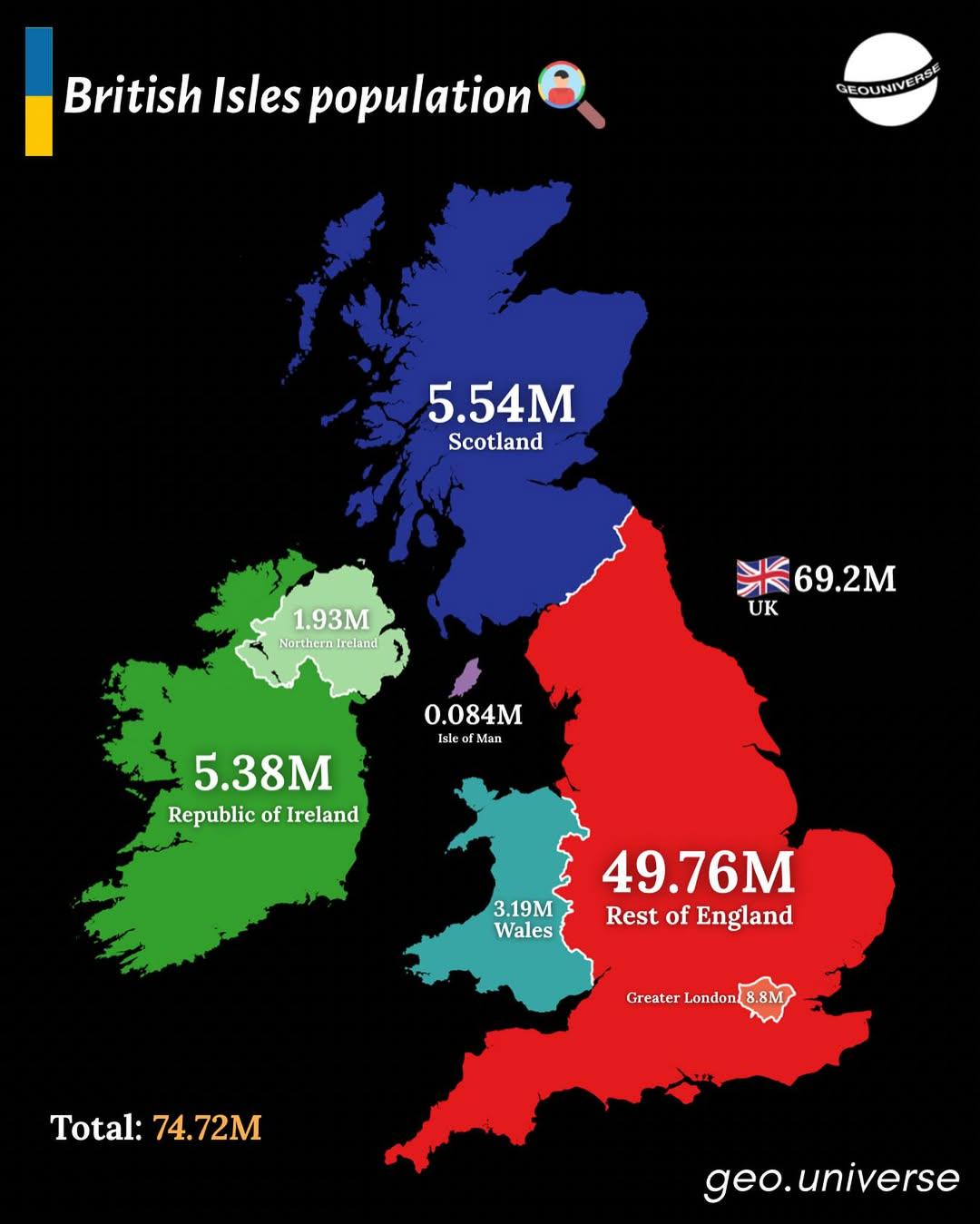
The "British Isles by Population" map presents a detailed visualization of the population distribution across the British Isles, which includes Great Britain, Ireland, and over 6,000 smaller islands. The map highlights the varying population densities in urban and rural areas, showing where people congregate and how that affects regional dynamics.
Population data is crucial for understanding how communities function, the pressures on infrastructure, and the social fabric of different regions. The British Isles, with its rich history and varied geography, presents a fascinating case study in population dynamics, influenced by factors such as industry, migration, and urbanization.
Deep Dive into Population Distribution
Ever wondered why certain areas of the British Isles are more populated than others? The distribution of population in this region is deeply influenced by historical, economic, and geographical factors. As of the latest estimates, the overall population of the British Isles is approximately 70 million, with England housing about 56 million, making it the most populous part of the islands.
The capital city, London, stands out with a staggering population density of around 5,700 people per square kilometer. This density is a testament to its role as a global financial hub, cultural center, and a magnet for international migration. Interestingly, London accounts for about 12% of England's total population, showcasing the concentration of people in urban centers.
In contrast, areas such as the Scottish Highlands or rural Wales exhibit much lower population densities, often under 10 people per square kilometer. These regions are characterized by their stunning landscapes and natural beauty, but they also face challenges such as economic stagnation and depopulation. The allure of urban life pulls younger generations towards cities, leaving behind aging populations in these rural areas.
Moreover, the population distribution is further complicated by migration patterns. The influx of immigrants into the British Isles over the past few decades has significantly influenced demographic changes, particularly in metropolitan areas. The diverse cultural tapestry of cities like Birmingham, Manchester, and Glasgow reflects this demographic shift, contributing to a vibrant multicultural society.
Regional Analysis
When examining the map, one can observe distinct regional patterns in population distribution. For instance, England, particularly the southeast, shows a high concentration of people. Areas like Kent and Essex are densely populated, benefiting from proximity to London and offering an appealing suburban lifestyle. However, this has led to increased housing demand and rising property prices, creating a unique set of challenges for local governments.
In contrast, Northern Ireland and Wales have lower population densities overall, but they have urban centers such as Belfast and Cardiff that demonstrate significant concentrations of residents. Belfast, for example, has been experiencing a resurgence, with urban regeneration projects attracting both residents and tourists alike.
Scotland offers another intriguing case. While cities like Edinburgh and Glasgow are populous, much of the northern and western parts of the country are sparsely populated. This reflects both the geography, with rugged terrain and harsh weather, and historical factors, such as the Highland Clearances, which drastically altered settlement patterns.
Significance and Impact
Understanding population distribution in the British Isles is essential for various reasons. It influences resource allocation, infrastructure development, and policy-making. For example, urban areas face challenges like overcrowding, transportation issues, and the need for sustainable development. In contrast, rural areas often require strategies to stimulate economic growth and retain younger populations.
Current trends indicate that urbanization will continue to rise, with projections suggesting that by 2030, nearly 90% of the British population will live in urban areas. This shift poses questions about how cities can accommodate growing populations while maintaining quality of life, managing environmental impacts, and ensuring equitable access to services.
In conclusion, the "Population Distribution Map of the British Isles" is more than just a visualization; it encapsulates the dynamic interplay of geography, history, and human activity. By analyzing these patterns, we can gain valuable insights into the future of communities across the British Isles, paving the way for informed decision-making and sustainable development in the region.
Visualization Details
- Published
- August 25, 2025
- Views
- 202
Comments
Loading comments...