Asian River Networks Map

Marcus Rodriguez
Historical Geography Expert
Marcus Rodriguez specializes in historical cartography and geographic data analysis. With a background in both history and geography, he brings unique...
Geographic Analysis
What This Map Shows
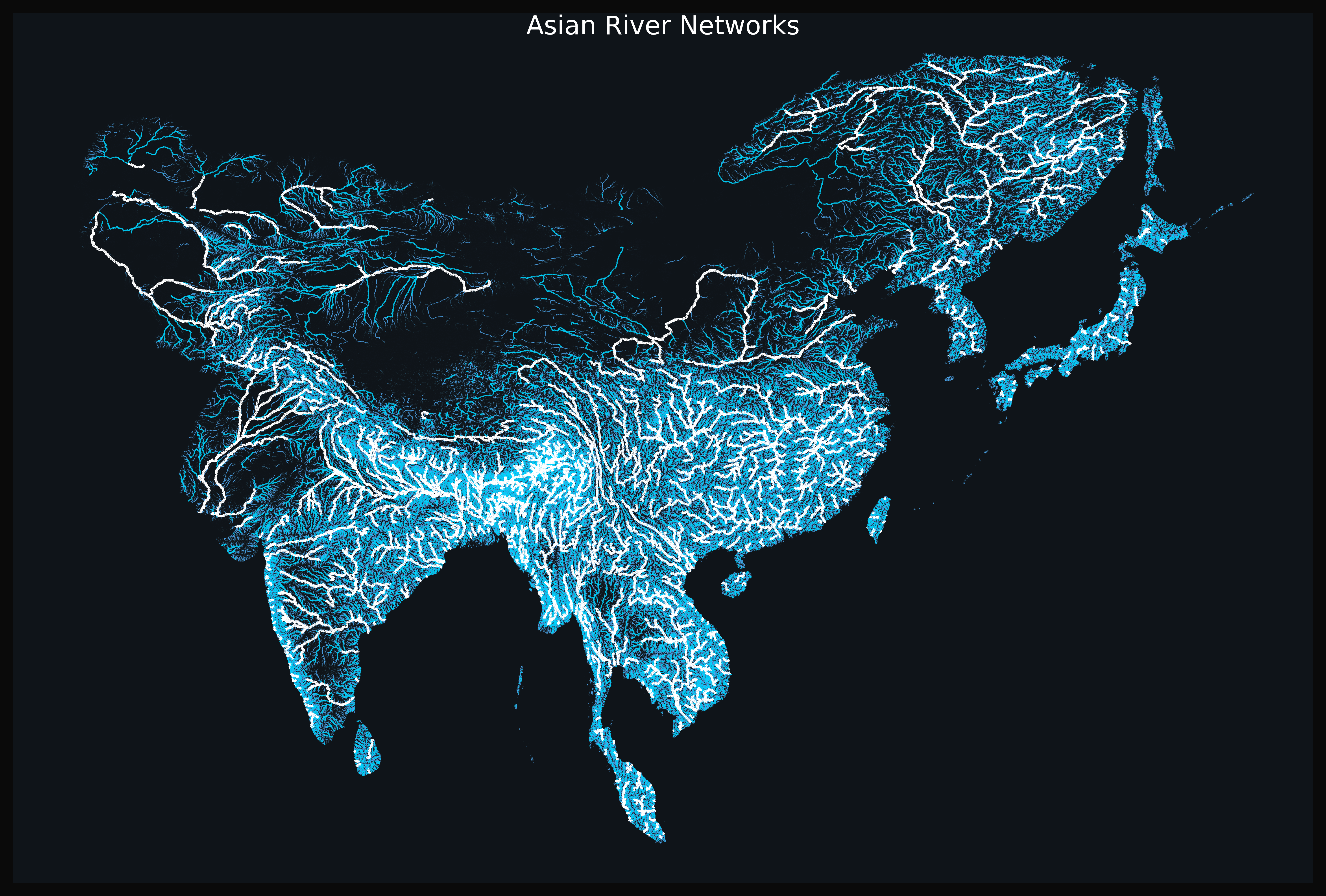
The "Asian River Networks Map" provides a detailed visualization of the intricate web of river systems across the continent of Asia. Rivers are not merely bodies of water; they are lifelines that shape the geography, economy, and culture of the regions they traverse. This map illustrates the major river networks, including their tributaries, flow patterns, and the various watersheds that delineate their courses. From the mighty Yangtze and Mekong to the sprawling Ganges, the map highlights how these rivers interconnect various landscapes and communities, playing a crucial role in the ecosystem and human activities.
Deep Dive into Asian River Systems
Rivers in Asia are among the longest and most significant in the world, serving multiple purposes from irrigation to transportation and even as sources of hydroelectric power. The continent is home to some of the largest river systems, which have developed unique characteristics influenced by the geography and climate of their respective regions.
For instance, the Yangtze River, which flows through China, is the longest river in Asia and the third longest in the world, measuring about 6,300 kilometers (3,917 miles). It serves as a crucial waterway for millions of people, supporting agriculture, industry, and domestic needs. Interestingly, the Yangtze basin is also rich in biodiversity, hosting numerous species of fish, birds, and other wildlife, making it a vital ecosystem that requires careful management to sustain.
On the other hand, the Ganges River, which flows through India and Bangladesh, holds immense cultural and religious significance. It's often referred to as the most sacred river in Hinduism. However, the Ganges faces severe pollution problems, impacting both its ecological health and the communities that depend on it. The river's basin is home to over 400 million people, making it one of the most densely populated areas globally. This presents a unique challenge for water management and conservation efforts as urbanization continues to encroach on the riverbanks.
The Mekong River is another significant waterway, flowing through six countries: China, Myanmar, Laos, Thailand, Cambodia, and Vietnam. Spanning over 4,350 kilometers (2,703 miles), it is vital for local economies, providing fish, rice, and other resources essential for survival. The Mekong delta, in particular, is a crucial agricultural area, but it is increasingly threatened by dam construction and climate change, which are altering its natural flow and impacting the livelihoods of millions.
What’s fascinating is that river systems are not just isolated entities; they are interconnected through a network of tributaries and watersheds. These connections create complex relationships within ecosystems, influencing sediment transport, nutrient cycling, and habitat availability. Understanding these dynamics is essential for effective water resource management, particularly in response to climate change and increased human activity.
Regional Analysis
When we analyze river networks regionally, we can observe distinct patterns and variations across Asia. In Southeast Asia, for example, the Mekong and its tributaries create a rich tapestry of wetlands and estuaries that support extensive biodiversity. The region's rivers are crucial for agricultural practices, particularly rice cultivation, which thrives in the fertile floodplains. However, the increasing demand for hydropower in this region poses a threat to these delicate ecosystems.
In contrast, Central Asia is characterized by its arid environment, where river systems like the Amu Darya and Syr Darya are vital for irrigation in otherwise dry landscapes. These rivers have faced severe depletion due to over-extraction for agricultural purposes, leading to significant environmental degradation, most notably the shrinking of the Aral Sea.
In South Asia, the vast river systems of the Indus and Ganges are essential for the densely populated regions they serve. The Indus River, originating in Tibet and flowing through India and Pakistan, is crucial for agriculture in Pakistan. However, political tensions over water rights between India and Pakistan complicate management efforts, highlighting the geopolitical implications of river systems.
Significance and Impact
The significance of river networks in Asia extends beyond just their physical presence; they are intertwined with cultural, economic, and environmental aspects of life. Rivers affect local economies, influence migration patterns, and serve as cultural symbols. Understanding these waterways is essential for sustainable development. As the impacts of climate change become more pronounced, including altered rainfall patterns and increased flooding, the management of river systems will play a critical role in mitigating these challenges.
Looking ahead, there is a growing recognition of the need for integrated water resource management that considers the interconnectedness of river systems and their surrounding environments. This approach aims to balance human needs with ecological integrity, ensuring that rivers can continue to support both people and wildlife. As urbanization and climate change pressures mount, the future of Asia's river networks will be a key area of focus for policymakers, conservationists, and communities alike.
Visualization Details
- Published
- August 14, 2025
- Views
- 84
Comments
Loading comments...