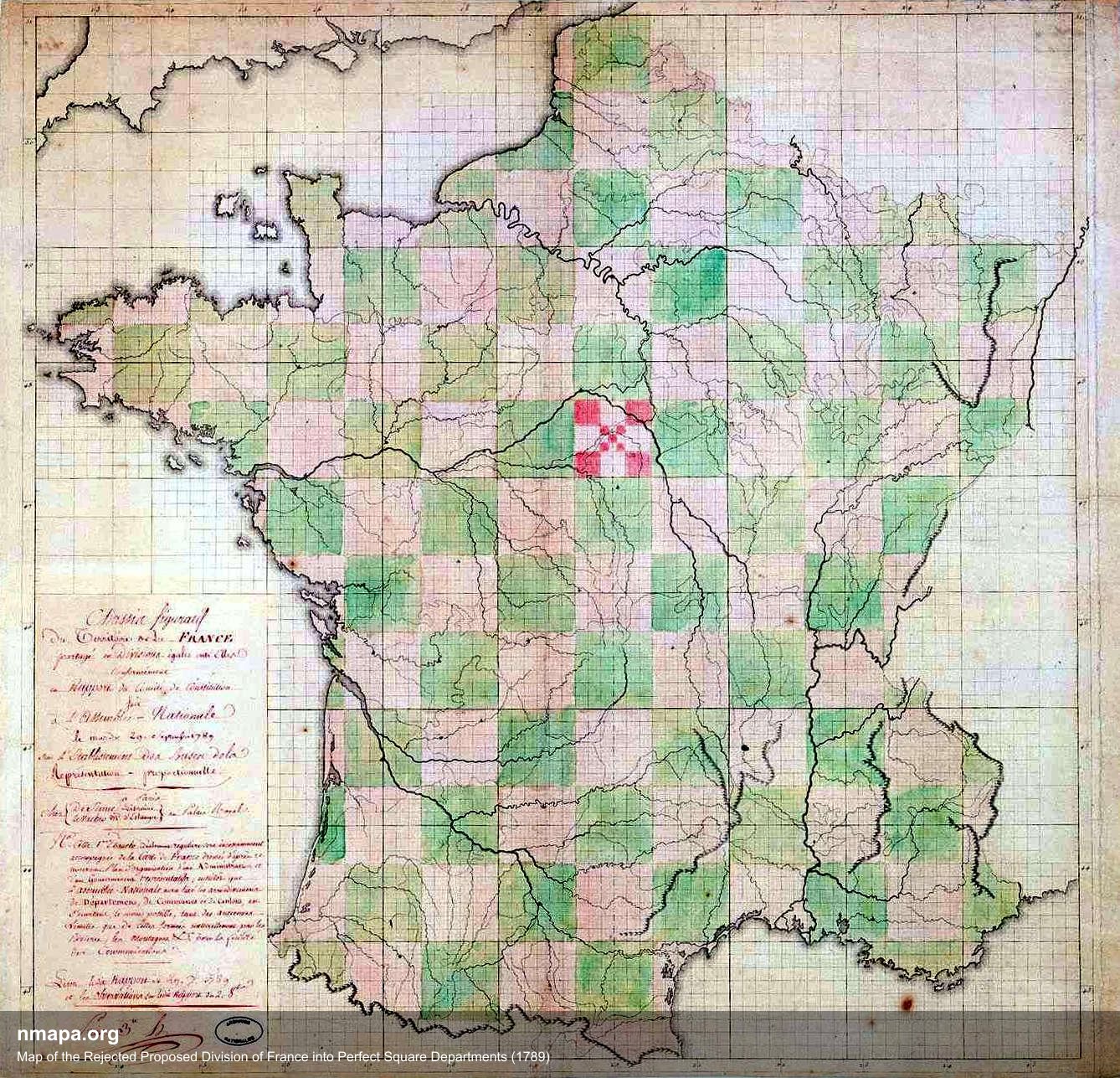
Map of the Rejected Proposed Division of France into Square Departments (1789)

Alex Cartwright
Senior Cartographer & GIS Specialist
Alex Cartwright is a renowned cartographer and geographic information systems specialist with over 15 years of experience in spatial analysis and data...
Geographic Analysis
What This Map Shows
This intriguing map illustrates the proposed division of France into square departments during the revolutionary period of 1789. The visualization reflects an ambitious plan to reorganize the country into uniform, square-shaped administrative regions, each meant to promote equality and accessibility in local governance. However, despite its innovative approach, this proposal was ultimately rejected, and France retained its existing regional divisions.
Deep Dive into the Historical Context of Administrative Divisions in France
The concept of dividing France into square departments stems from the Enlightenment ideals that fueled the French Revolution. Revolutionary leaders sought to dismantle the feudal system and promote a more equitable society. The proposal aimed to create departments that would be administratively simpler and more uniform, embodying the revolutionary spirit of rationalism and equality.
Interestingly, the idea of square-shaped administrative units was not just about aesthetics; it was also about functionality. The intention was to ensure that each department would have equal resources, population, and representation. With square shapes, it was believed that each department could improve communication and governance. However, the reality of France’s geography posed significant challenges. The diversity of landscapes, cultures, and existing political boundaries made a simple square division impractical.
The proposed departments would have replaced the old provinces, which were often irregular in shape and varied widely in size and population. For example, regions like Île-de-France, which includes Paris, would have drastically different demographics and needs compared to the more rural and less populated areas of Brittany or Normandy. The revolutionary leaders ultimately recognized that a one-size-fits-all approach would fail to account for these regional disparities.
Furthermore, the French Revolution was marked by significant political upheaval and social change. The leaders were balancing numerous competing interests, and the square division would not adequately address the complexities of local governance in a country that had been historically fragmented. The rejection of the square department proposal illustrated the challenges of reforming a nation with deep-rooted historical identities and geographic variations.
Regional Analysis
Examining the regions of France, the proposed square departments would have resulted in significant variation across the country. For instance, northern regions like Hauts-de-France, characterized by industrial towns and urban centers, would have likely experienced different administrative needs compared to southern regions such as Provence-Alpes-Côte d'Azur, known for agriculture and tourism.
Moreover, the central region of Auvergne-Rhône-Alpes presents an interesting case. The mountainous terrain and rural communities would have posed logistical challenges in governance that a square division might not have effectively addressed. Interestingly, the size of the proposed departments would have also varied widely, complicating governance further. A square department covering a densely populated urban area would have vastly different needs compared to one encompassing a sprawling rural landscape.
Additionally, the historical provinces that were to be replaced had their own unique identities and governance systems. For example, regions like Brittany had a distinct cultural identity that would be undermined by a square administrative division. The tensions between local identities and the push for uniform governance reflect the complexities of national unity versus regional diversity.
Significance and Impact
The rejection of the proposed square departments in 1789 is significant for several reasons. It highlights the difficulties inherent in reforming a nation with rich historical and regional diversity. The failure to implement a uniform division underscores the importance of local governance and the need to consider geographical and cultural factors in administrative decisions.
Today, the implications of such historical proposals can still be felt in contemporary France, where regional identities remain strong. The ongoing discussions about decentralization and local governance reflect the legacy of these revolutionary ideas. Interestingly, these debates are particularly relevant in a world increasingly focused on local autonomy and regionalism.
Moreover, the map serves as a reminder of how geographical considerations influence political decisions. As cities and regions evolve, understanding their historical administrative structures remains crucial. Ever wondered why certain regions have more autonomy or different governance systems? It often traces back to these foundational decisions made centuries ago.
In conclusion, the rejected proposal for square departments in France during 1789 offers a fascinating glimpse into the challenges of governance. The interplay between revolutionary ideals and the realities of geography is a lesson that resonates in modern political discourse, highlighting the need for balance between uniformity and local identity in governance.
Visualization Details
- Published
- August 2, 2025
- Views
- 160
Comments
Loading comments...