1918 Ethnicity Map of Europe

Alex Cartwright
Senior Cartographer & GIS Specialist
Alex Cartwright is a renowned cartographer and geographic information systems specialist with over 15 years of experience in spatial analysis and data...
Geographic Analysis
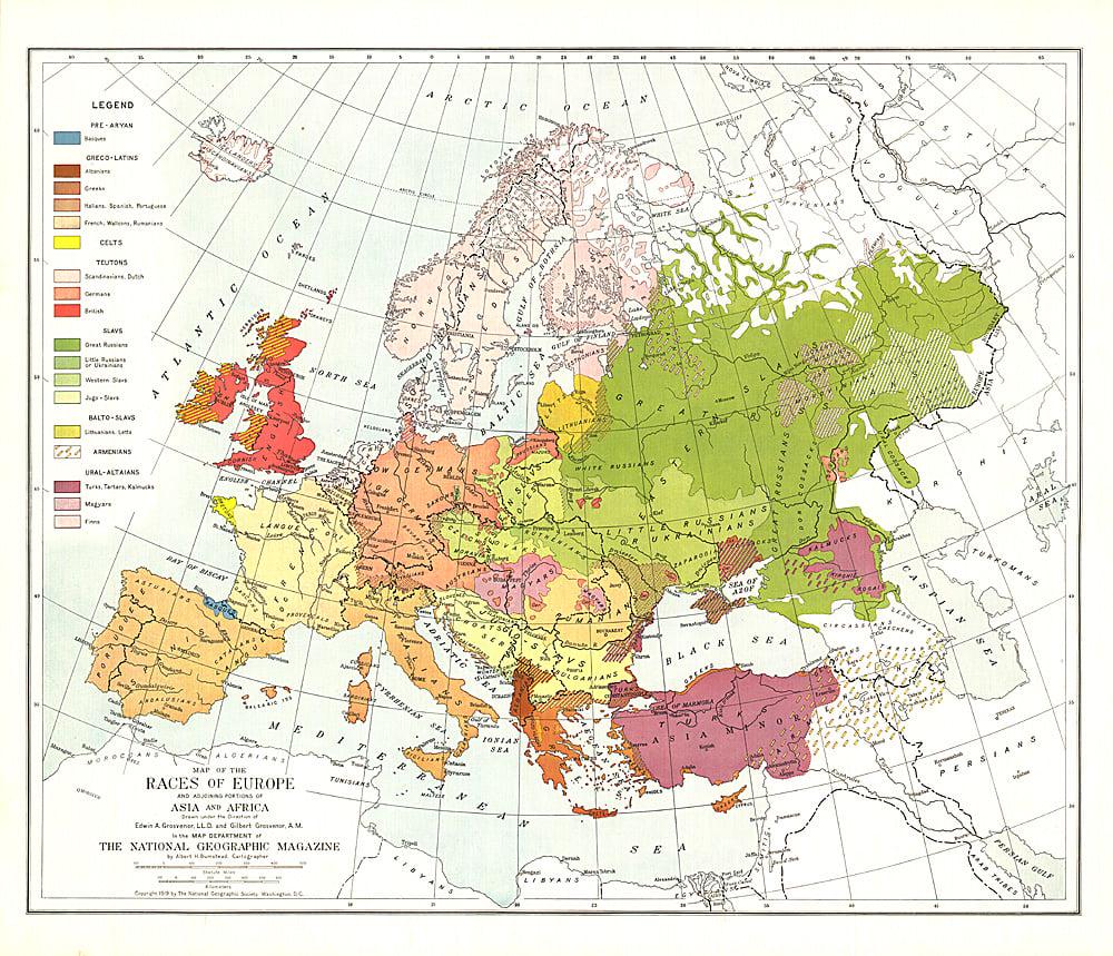
What This Map Shows
The 1918 Ethnicity Map of Europe presents a detailed snapshot of the ethnic composition of the continent shortly after World War I. This visualization highlights the diverse tapestry of cultural and national identities that existed in Europe during a time of significant political upheaval and territorial change. Following the war, many nations were redefined, and the map serves as a historical reference point illustrating the distribution of various ethnic groups, from Slavs and Germans to Hungarians and Romanians.
Interestingly, this map not only depicts where different ethnic groups resided but also provides insight into the tensions that arose as new nation-states emerged and existing borders were redrawn. The implications of these ethnic distributions would resonate for decades, influencing national policies, conflicts, and migrations across Europe.
Deep Dive into Ethnicity in Early 20th Century Europe
The early 20th century was a pivotal moment for ethnic identities in Europe, shaped by a variety of historical events, including the decline of empires and the rise of nationalist movements. Ethnicity, in this context, refers to shared cultural traits, languages, and historical experiences that bind groups together. Post-World War I, the map reveals a Europe marked by a complex mosaic of ethnicities, with significant populations of Germans, Poles, Czechs, Hungarians, Italians, and many others living in proximity.
One of the most significant aspects of this map is the impact of the Austro-Hungarian Empire's dissolution. The empire's collapse in 1918 led to the formation of several new nations such as Czechoslovakia and Yugoslavia, which were created to reflect the desires of various ethnic groups for self-determination. For instance, Czechoslovakia united Czechs and Slovaks, while Yugoslavia aimed to bring together South Slavic peoples, including Serbs, Croats, and Slovenes.
The ethnic diversity depicted on the map also highlights the tensions that would lead to future conflicts. With borders drawn largely without regard to the ethnic distributions, many minority groups found themselves in newly formed states that did not represent their national identity. For example, the Sudeten Germans in Czechoslovakia and the Poles in the new borders of East Prussia were left to navigate their identities within a national framework that often marginalized them.
Moreover, the aftermath of the war saw significant population movements as people sought to align themselves with their ethnic kin, leading to tensions and, at times, violence. Historical records indicate that these population shifts were not merely voluntary; they were often coerced through policies or societal pressures that sought to create ethnically homogeneous nation-states.
Regional Analysis
Examining the map regionally reveals stark contrasts in ethnic composition. In Eastern Europe, for example, the borders of Poland were redrawn to include a significant number of ethnic Ukrainians and Belarusians. This inclusion was contentious and would lead to ethnic strife in subsequent decades. Conversely, in Western Europe, nations like France and Germany had more homogenous populations, although they still had to grapple with regional minorities. The Alsatians in France and the French in Germany were remnants of historical tensions that had existed before the war.
In the Balkans, a region notoriously known for its ethnic diversity, the map illustrates a complex interplay of identities. The newly formed Yugoslavia attempted to unite a plethora of ethnic groups, but this very attempt sowed the seeds for future conflicts. The differences between Serbs, Croats, and Bosniaks were not merely cultural but also tied to religious identities, further complicating the national narrative.
Significance and Impact
Understanding the ethnic landscape of 1918 Europe is crucial for several reasons. Firstly, it provides context for the nationalistic sentiments that would lead to World War II and the subsequent conflicts in the Balkans in the 1990s. The historical grievances and alliances formed in the aftermath of World War I continue to shape contemporary European politics and identity.
Moreover, as we observe current trends in nationalism and migration across Europe, it's evident that the echoes of the past still resonate today. Ethnic minorities continue to negotiate their identities within increasingly diverse societies. The lessons from the 1918 Ethnicity Map of Europe remind us of the importance of inclusivity and the potential consequences of ethnic divisions.
In conclusion, the 1918 Ethnicity Map of Europe is more than just a historical artifact; it is a critical lens through which we can examine the intricate relationships between ethnicity, national identity, and geopolitical dynamics. As Europe continues to evolve, understanding these historical contexts will be imperative for fostering peace and unity in a richly diverse continent.
Visualization Details
- Published
- October 24, 2025
- Views
- 14
Comments
Loading comments...