Political Map of Europe January 1914

David Chen
Data Visualization Specialist
David Chen is an expert in transforming complex geographic datasets into compelling visual narratives. He combines his background in computer science ...
Geographic Analysis
What This Map Shows
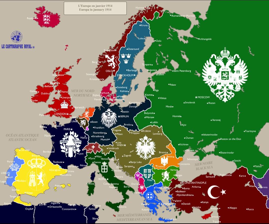
The "Europe in January 1914" map provides a snapshot of the political landscape of Europe just months before the outbreak of World War I. This visualization highlights the various empires, nations, and territories that existed at the time, showcasing borders, major cities, and key geographic features. The map is a crucial historical document, representing the complex alliances and rivalries that characterized the continent in the early 20th century.
Transitioning from the mere visual representation, let’s delve into the geopolitical dynamics of Europe during this pivotal moment in history.
Deep Dive into European Politics in 1914
In January 1914, Europe was a patchwork of empires and nation-states, many of which were on the brink of conflict. The map reveals the vast Austro-Hungarian Empire, which stretched across Central and Eastern Europe, encompassing diverse ethnic groups and nationalities. This empire was marked by internal tensions, largely due to the aspirations of Slavic nationalities seeking independence.
Meanwhile, the German Empire, a major player on the continent, was solidifying its power. The Kaiser’s ambitions for expansion and influence were creating friction with neighboring France and Russia. Interestingly, the Franco-German rivalry had roots going back to the Franco-Prussian War of 1870-71, and it was clear that underlying animosities remained unresolved.
On the other hand, the Russian Empire, with its vast territory, was struggling with social unrest and revolutionary movements. The presence of Poland, which was partitioned among Germany, Russia, and Austria-Hungary, highlighted the national aspirations that were stirring among various ethnic groups.
This map also sheds light on the Balkan region, which was a hotbed of nationalistic fervor and territorial disputes. The Balkan Wars of 1912-1913 had dramatically reshaped borders and heightened tensions. Countries like Serbia were expanding at the expense of the Ottoman Empire, leading to a volatile situation that would soon draw in major powers.
Overall, the political landscape in Europe in January 1914 was characterized by a precarious balance of power, where alliances and enmities were intricately woven. The Triple Alliance of Germany, Austria-Hungary, and Italy faced off against the Triple Entente of France, Russia, and the United Kingdom. These alliances would dictate the course of history as the continent plunged into war just months later.
Regional Analysis
Breaking down the political map by region reveals significant differences and tensions. In Western Europe, the industrialized nations of Germany, France, and the UK were not only military powers but also economic juggernauts. Germany's rapid industrialization had created a sense of superiority, which often put it at odds with France, particularly over colonial ambitions in Africa and Asia.
In contrast, Southern Europe, especially the Balkans, was marked by a mix of emerging national identities and the remnants of Ottoman control. Countries like Serbia and Bulgaria were keen on expanding their territories, which complicated relations with Austria-Hungary and Russia. The assassination of Archduke Franz Ferdinand in June 1914, which was fueled by Serbian nationalism, would serve as the spark igniting World War I.
In Eastern Europe, the map highlights the diverse ethnic landscape within the Austro-Hungarian Empire. Regions like Galicia were home to Ukrainians, Poles, and Jews, each vying for recognition and autonomy. The tensions in this area reflected broader struggles that would play out on the world stage after the war.
Significance and Impact
Understanding the political landscape of Europe in January 1914 is crucial for grasping the subsequent events that led to World War I. The alliances formed during this period, driven by mutual distrust and competitive nationalism, set the stage for a conflict that would reshape the world.
What's fascinating is that the outcomes of World War I had lasting implications not just for Europe but for global politics. The redrawing of borders and the creation of new nations post-war were directly influenced by the tensions highlighted in this map.
Today, the legacy of this era is still felt, as many of the nationalistic conflicts and territorial disputes that emerged continue to affect geopolitics. Understanding the political divisions of January 1914 allows us to see the roots of contemporary issues in regions such as the Balkans and Eastern Europe, where historical grievances remain potent.
As we reflect on this map, it serves as a reminder of how fragile peace can be and how quickly the landscape of international relations can shift. The maps we look at today may offer insights into current geopolitical tensions, echoing the complexities of a world that was forever altered by the events that unfolded from that fateful summer in 1914.
Visualization Details
- Published
- October 19, 2025
- Views
- 64
Comments
Loading comments...