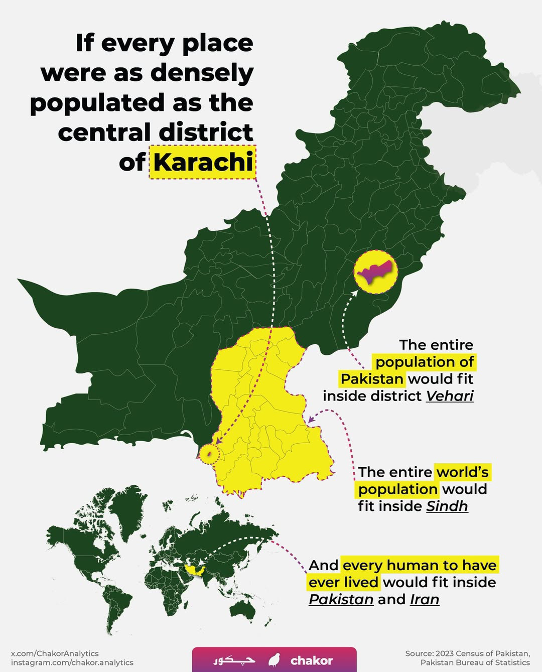
Karachi Population Density Map


Alex Cartwright
Senior Cartographer & GIS Specialist
Alex Cartwright is a renowned cartographer and geographic information systems specialist with over 15 years of experience in spatial analysis and data...
Geographic Analysis
What This Map Shows\nThe Karachi Population Density Map provides a detailed visualization of the population distribution across one of the largest cities in Pakistan. This map highlights the varying population densities in different neighborhoods and districts, illustrating areas of high concentration as well as those that are sparsely populated. With Karachi being a bustling metropolis and a significant economic hub, understanding its population dynamics is crucial for urban planning, resource allocation, and public services.
Deep Dive into Karachi's Population\nKarachi, often referred to as the 'City of Lights', is not just the largest city in Pakistan; it is also one of the most populous cities in the world. As of the latest estimates, Karachi has a population exceeding 16 million people, making it a megacity in every sense. The demographic landscape of Karachi is incredibly diverse, both ethnically and socioeconomically. The city serves as a melting pot of cultures, with a mix of Sindhis, Muhajirs, Pashtuns, Baloch, and various other ethnic groups contributing to its rich tapestry.
Interestingly, the population density can vary dramatically within the city. For instance, areas like Saddar and Gulshan-e-Iqbal are known for their high population densities, which can exceed 100,000 people per square kilometer. This contrasts sharply with the outskirts of the city, such as Gadap Town, where population density is significantly lower, often below 1,000 people per square kilometer. This disparity raises questions about urban development and the availability of services.
Urbanization in Karachi has surged over the past few decades, primarily due to rural migration. People flock to the city in search of better employment opportunities and living standards, leading to rapid expansion and, unfortunately, often unplanned urban sprawl. The city's infrastructure has struggled to keep pace with this growth, resulting in challenges such as traffic congestion, inadequate housing, and strained public services.
Moreover, the demographic trends point towards a youthful population. Approximately 60% of Karachi's residents are under the age of 30. This youthful demographic is a double-edged sword; while it offers potential for economic growth, it also presents challenges in terms of education, job creation, and social services. Have you ever wondered how this youthful population will shape Karachi's future?
Regional Analysis\nExamining the map closely, we can see distinct regional variations in population density across Karachi. The central and southern districts, such as South Karachi and East Karachi, show significantly higher densities compared to the northern suburbs. These densely populated areas often face challenges such as inadequate public transportation and insufficient healthcare services, making it crucial for city planners to prioritize these regions for development.
For example, in the South District, neighborhoods like Korangi and Landhi are not only densely populated but also economically challenged, with limited access to basic amenities. Conversely, areas like DHA (Defence Housing Authority) and Clifton, located in the southern part of the city, boast lower population densities but are known for their higher socio-economic status. This contrast highlights the stark inequalities present in Karachi's urban landscape.
Significance and Impact\nUnderstanding Karachi's population distribution is vital for several reasons. Firstly, it informs urban planners and policymakers about where resources and services are most needed. As the population continues to grow, the demand for housing, healthcare, education, and employment will only increase. Addressing these needs is essential for fostering a sustainable urban environment.
Moreover, Karachi’s population dynamics have significant implications for the broader socio-economic fabric of Pakistan. The city's economy is heavily dependent on its human resources; hence, the interplay between population density and economic activity can drive or hinder growth. Current trends indicate a shift towards technology and services, reflecting a global move towards digital economies. However, this transition requires an educated workforce, which underscores the importance of investing in education and training programs.
Looking ahead, projections suggest that Karachi's population could reach over 25 million by 2030. This rapid growth calls for urgent attention to urban planning and infrastructure development to ensure that the city remains livable and functional. The ongoing challenges of climate change, such as rising sea levels and extreme weather events, also necessitate a focus on sustainable practices and resilient urban design.
In conclusion, the Karachi Population Density Map is not just a visualization; it is a critical tool that encapsulates the complex relationship between population, urbanization, and socio-economic dynamics. As Karachi continues to grow, understanding these patterns will be vital for shaping its future.
Visualization Details
- Published
- October 18, 2025
- Views
- 34
Comments
Loading comments...