Political Map of the Middle East in the 9th Century

David Chen
Data Visualization Specialist
David Chen is an expert in transforming complex geographic datasets into compelling visual narratives. He combines his background in computer science ...
Geographic Analysis
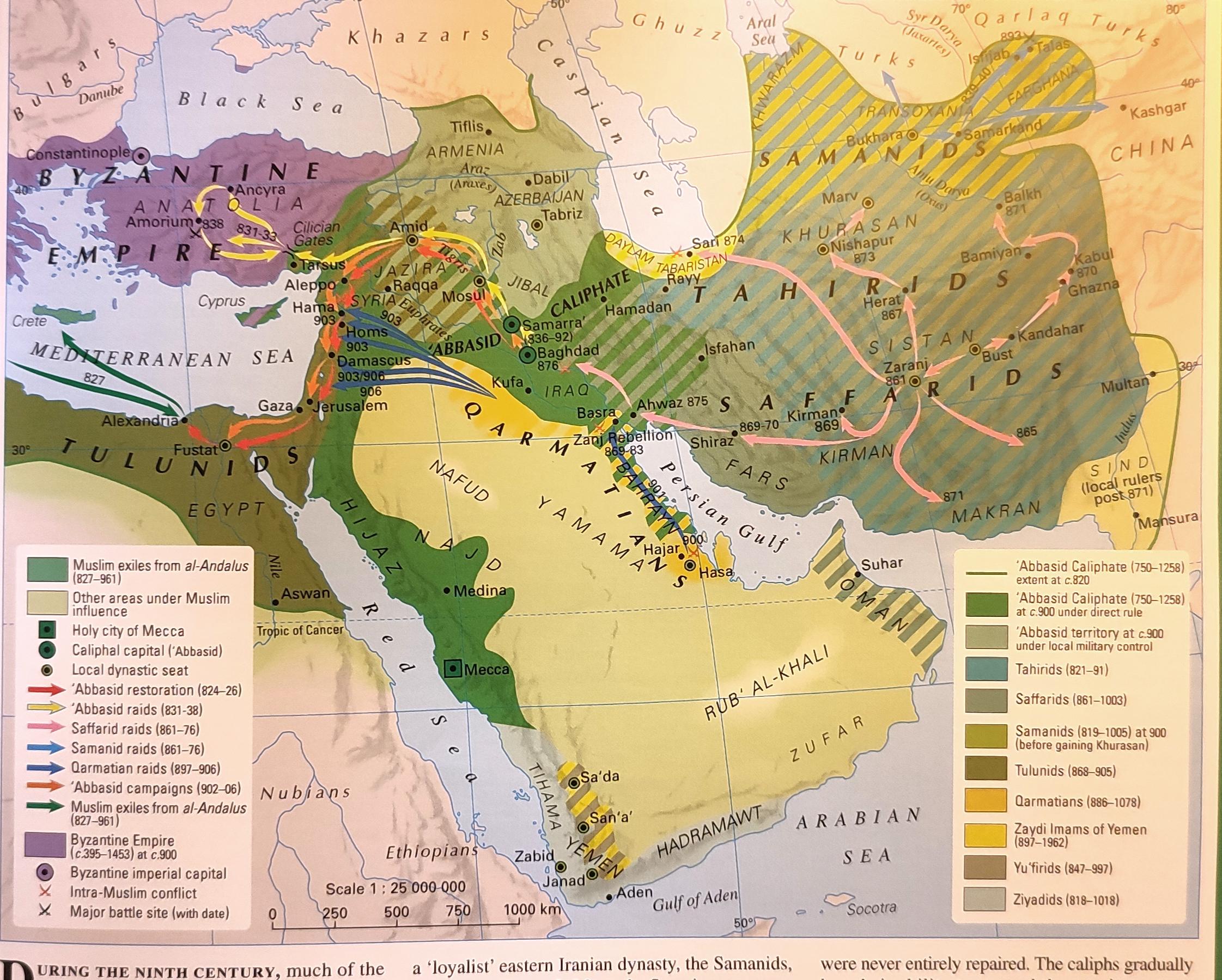
What This Map Shows
This map provides a detailed political visualization of the Middle East during the 9th century, highlighting the various empires, caliphates, and important cities that defined the region at that time. It captures a period of significant cultural and political development, illustrating the power dynamics that influenced the course of history in the area.
Deep Dive into Political Landscape
The 9th century was a pivotal time in the Middle East, characterized by the emergence and consolidation of several powerful entities, most notably the Abbasid Caliphate. Founded in 750 AD, the Abbasid Caliphate centered its capital in Baghdad, which became a hub of learning, commerce, and culture. Interestingly, at its height, the Abbasid realm stretched across a vast expanse, encompassing parts of present-day Iraq, Iran, Syria, Egypt, and beyond, creating one of the largest empires of its time.
The map reveals how the Abbasid Caliphate was not just a political unit but a melting pot of cultures, ideas, and innovations. Baghdad, often referred to as the 'City of Peace,' was crucial in the translation of ancient texts and the pursuit of knowledge. Have you ever wondered how the House of Wisdom functioned as an intellectual center? Scholars from diverse backgrounds gathered there, contributing to advancements in mathematics, astronomy, and philosophy.
However, the political landscape was not without challenges. The Abbasid Caliphate faced significant fragmentation due to internal strife and external pressures. By the later part of the century, various provinces began asserting independence, leading to the rise of regional powers such as the Tulunids in Egypt and the Saffarids in Persia. These changes marked the beginning of a more fragmented political scene that would characterize the Middle East in subsequent centuries.
Moreover, trade routes that crisscrossed the region played a crucial role in the economic stability of these entities. The Silk Road and maritime routes facilitated not just commerce, but also cultural exchanges, making cities like Damascus and Cairo key players in the global economy. It’s fascinating to consider how this interconnectedness laid the groundwork for the cultural richness that would follow.
Regional Analysis
When we look closely at the regions depicted in the map, we see distinct differences in political organization and cultural influence. For instance, while the Abbasid Caliphate dominated the central part of the Middle East, the Byzantine Empire still held sway in parts of Anatolia and the Levant. This juxtaposition of Islamic and Christian territories created a unique cultural tapestry, influencing everything from art to architecture.
In the southern regions like Arabia, the political landscape was influenced by tribal affiliations, which were often at odds with the more centralized governance of the Abbasids. Here, powerful families and clans maintained significant autonomy, demonstrating the complex interplay between tribal and imperial authority. This regional variation is essential to understanding the Middle East's historical narrative.
Interestingly, the map also highlights the significant role of the Mediterranean Sea in shaping regional politics. Coastal cities like Tyre and Sidon were vital trade hubs, impacting not only local economies but also the broader geopolitical dynamics of the time. The interactions between these coastal cities and their inland counterparts further illustrate the diverse political realities of the 9th century.
Significance and Impact
Understanding the political map of the Middle East in the 9th century is crucial for several reasons. First, it provides insight into the historical roots of contemporary conflicts and alliances. The legacy of the Abbasid Caliphate, for example, continues to influence modern political boundaries and cultural identities in the region.
Moreover, the period marked significant advancements in science, technology, and culture that have had lasting impacts. The innovations of the 9th century laid the groundwork for the European Renaissance and influenced various fields, including medicine and mathematics.
Today, as we examine the historical contexts of modern geopolitical issues, we can trace many of these conflicts back to the power dynamics established during the 9th century. The implications of these historical developments are still felt today, as nations navigate complex relationships shaped by centuries of history.
In conclusion, this map not only serves as a historical record but also as a reminder of the rich tapestry that is Middle Eastern history. By understanding the political landscape of the 9th century, we can better appreciate the cultural and historical complexities that define the region today.
Visualization Details
- Published
- September 24, 2025
- Views
- 70
Comments
Loading comments...