Map of Germany Before Unification (1815-1866)

Marcus Rodriguez
Historical Geography Expert
Marcus Rodriguez specializes in historical cartography and geographic data analysis. With a background in both history and geography, he brings unique...
Geographic Analysis
What This Map Shows
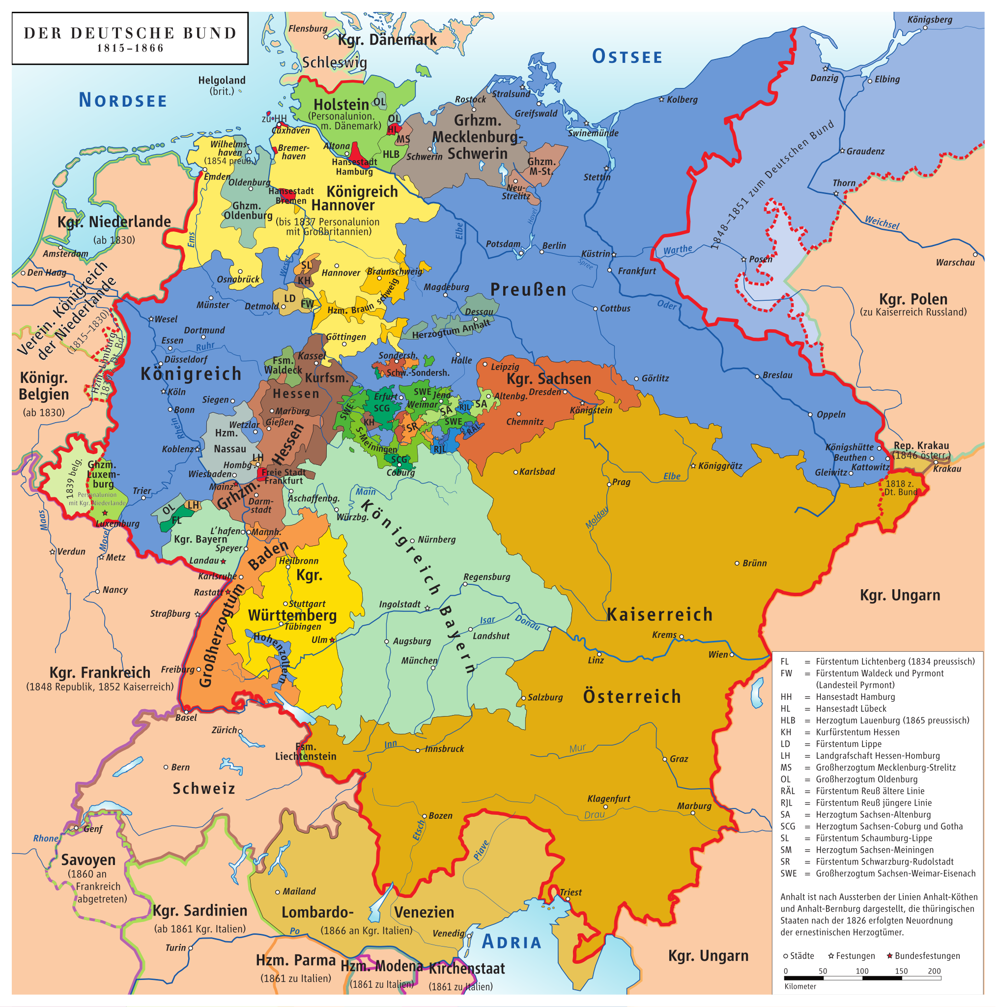
This map titled "Germany Before Being Germany (1815-1866)" provides a detailed visualization of the political landscape of Central Europe during a crucial period leading up to the unification of Germany. It illustrates the various German states, principalities, and territories that existed prior to 1871, when the German Empire was officially established. The map highlights the complex patchwork of political entities, including the Kingdom of Prussia, the Austrian Empire, and numerous smaller duchies, free cities, and territories, each with its own unique governance and cultural identity.
Deep Dive into the German States
The early 19th century was a transformative time for German-speaking territories. Prior to unification, the region was a mosaic of independent states that reflected a rich history of feudalism, territorial disputes, and shifting alliances. The Congress of Vienna in 1815 played a significant role in shaping the political boundaries and governance structures of these states following the Napoleonic Wars.
Interestingly, the Kingdom of Prussia emerged as a dominant force during this era, gradually expanding its territory and influence. By 1866, Prussia had strategically engaged in wars that would set the stage for the unification of Germany. The Austro-Prussian War of that year is particularly notable, as it led to the exclusion of Austria from German affairs and solidified Prussia's leadership among German states.
The map also showcases key cities, such as Berlin, which was not only the political capital of Prussia but also a burgeoning cultural and industrial hub. Meanwhile, cities like Munich, Stuttgart, and Frankfurt each held their own significance, serving as centers of trade, culture, and political power within their respective states.
Demographically, the German-speaking population was highly diverse, with distinct regional identities influenced by dialects, traditions, and historical legacies. For example, the southern states, including Bavaria and Baden, retained strong cultural identities that were often at odds with the more industrialized and militaristic north.
The complexities of these states would culminate in the eventual unification, but prior to that, the political fragmentation allowed for a vibrant array of cultural and economic developments. This period also saw the rise of nationalism, which played a pivotal role in uniting these disparate German states under a common identity.
Regional Analysis
Breaking down the map further, we can observe several key regions:
- **Prussia**: As the largest and most powerful state, Prussia’s influence extended over much of northern and central Germany. Its efficient bureaucracy and military prowess made it a model for governance, attracting admiration and rivalry alike. - **Bavaria**: Known for its distinct culture and traditions, Bavaria was a significant player in the southern German states. Its resistance to Prussian dominance was marked by a strong sense of regional pride and identity. - **The Austrian Empire**: While not a German state in the modern sense, Austria's influence over German-speaking territories was profound. The map illustrates how Austria controlled various duchies and principalities in the south and offered a counterbalance to Prussian ambitions. - **Free Cities**: Cities like Hamburg, Bremen, and Lübeck, marked on the map as free cities, played essential roles in commerce and trade. Their autonomy allowed them to thrive economically, contributing to the overall prosperity of the region.
The interactions among these regions were complex. For instance, while Prussia pushed for greater centralization, states like Bavaria and Saxony often favored a more confederate approach, fearing loss of local autonomy. This tension would shape the political discourse leading up to unification.
Significance and Impact
Understanding this map and the geopolitical landscape of pre-unified Germany is crucial for grasping the historical context of modern Germany. The fragmented political entities and the rise of nationalism not only set the stage for unification but also influenced European politics at large.
Today, the legacy of this era can be seen in the cultural and regional identities that persist within Germany. The unification process was not just a political maneuver; it also represented a collective yearning for identity and cohesion among the German people.
Moreover, the dynamics of the period remind us of the complexities that can arise when diverse cultures and political entities seek to forge a common identity. Current discussions around regional autonomy and national identity in Germany often hark back to this foundational period. As we look to the future, understanding these historical nuances becomes essential in navigating contemporary issues related to nationalism, unity, and diversity within the nation.
In conclusion, the map of Germany before unification is not merely a depiction of political boundaries; it encapsulates a rich tapestry of history, culture, and identity that continues to resonate today.
Visualization Details
- Published
- September 24, 2025
- Views
- 50
Comments
Loading comments...