Number of Signed Highways Map by U.S. State and Canadian Province

Alex Cartwright
Senior Cartographer & GIS Specialist
Alex Cartwright is a renowned cartographer and geographic information systems specialist with over 15 years of experience in spatial analysis and data...
Geographic Analysis
What This Map Shows
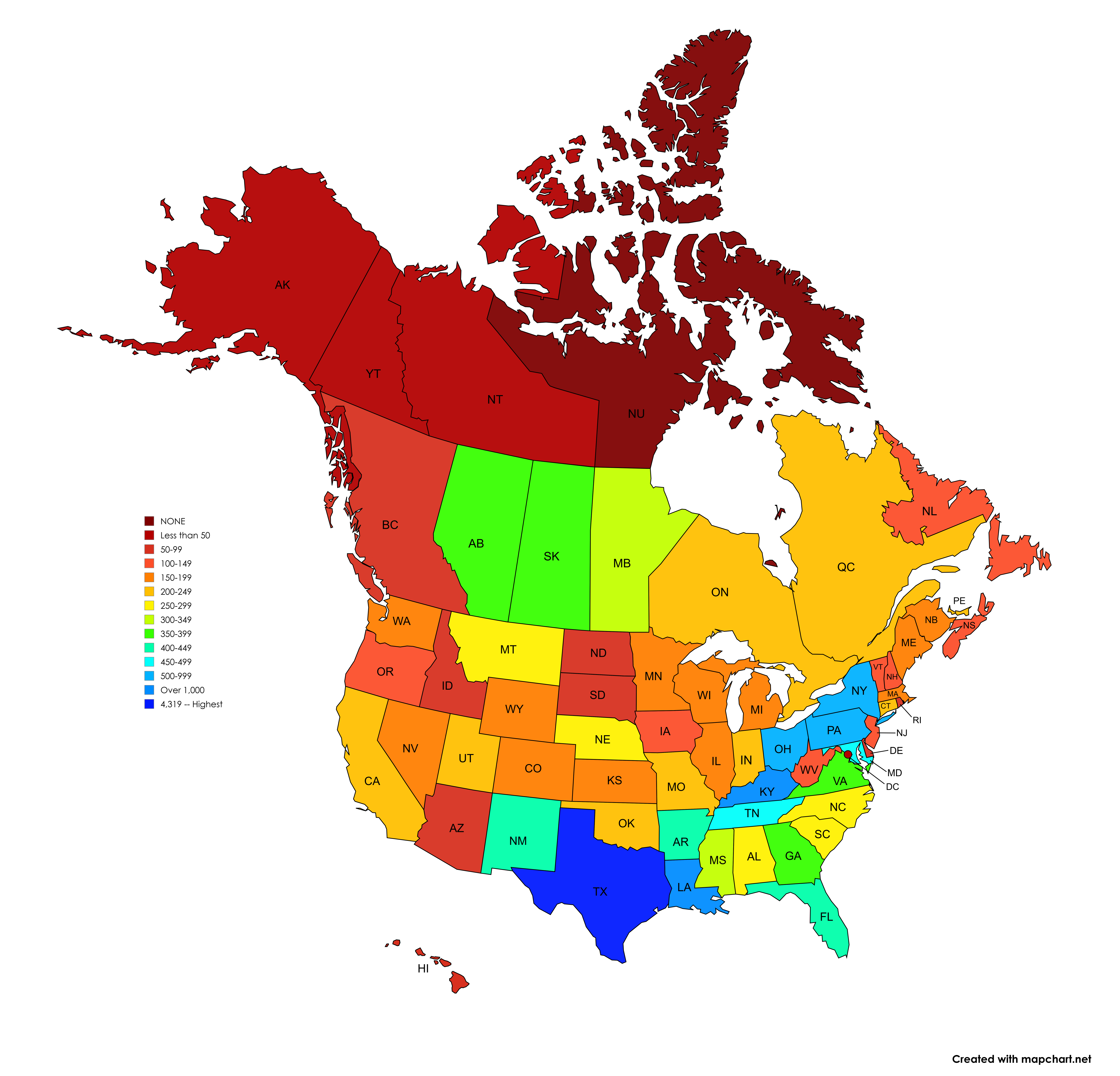
The visualization titled 'Number of Signed Highways in each U.S. State and Canadian Province' presents a detailed count of the signed highways, including Interstate, U.S. Routes, state-level highways for the United States, and provincial highways for Canada. It's essential to note that this map excludes business and auxiliary routes, duplicated route numbers, and unsigned routes. The counts reflect a comprehensive effort that has taken years of meticulous research and data gathering.
As we delve into the topic of highways, it's interesting to recognize how these routes serve as vital arteries for transportation, commerce, and connectivity within and between regions. Highways are not just roads; they represent the lifeblood of economic activity, social interactions, and cultural exchanges across diverse landscapes.
Deep Dive into Signed Highways
Highways are crucial for facilitating movement and trade. In the United States, the Interstate Highway System, established in 1956, dramatically reshaped how Americans travel and transport goods. This system was designed to provide a high-speed, limited-access network that connects major cities and regions across the country. Interestingly, the number of signed highways varies greatly from one state to another, reflecting differences in geography, population density, and historical development.
For example, Texas stands out prominently in this visualization with a staggering count of signed highways—248 state highways, 203 numbered loop roads, 219 numbered spur roads, 78 park roads, and a whopping 3,438 farm-to-market roads. This multi-tiered highway system is a reflection of Texas’s vast land area and significant agricultural output. The farm-to-market roads, in particular, are designed to connect rural areas with urban markets, supporting the state's economy.
In contrast, states like Kentucky and Louisiana showcase thousands of state-level highways under the same designation. This consolidation can be attributed to different administrative approaches to highway management, which can sometimes lead to confusion in navigation but aims to provide comprehensive coverage.
Moreover, the map outlines the Canadian provinces, which have their own systems of signed highways. The Trans-Canada Highway (TCH) is a noteworthy feature, providing a vital link across the provinces. However, it's essential to note that the three territories are not included in this count, highlighting a geographical distinction in how highway systems are structured and maintained.
Regional Analysis
When we analyze the data regionally, notable patterns emerge. The Western United States, for instance, tends to have a more extensive network of highways due to its larger landmass and lower population density in certain areas. States like California and Nevada have developed significant highway networks to connect urban centers like Los Angeles and Las Vegas, respectively.
Conversely, Northeastern states, which are more densely populated, often have a higher concentration of shorter highways that facilitate local travel. States like New York and New Jersey, with their heavy traffic volumes, have numerous routes that cater to both local commuters and long-distance travelers.
In Canada, provinces such as Ontario and Quebec also demonstrate substantial highway networks, reflecting their higher populations and urban centers. The connectivity offered by these highways plays a crucial role in regional economic development and accessibility.
Significance and Impact
Understanding the distribution of signed highways is vital for several reasons. First, these routes are essential for emergency services, public transportation, and evacuation during natural disasters. As climate change escalates, the resilience of highway systems becomes increasingly important in disaster preparedness and response.
Moreover, with the rise of e-commerce and the need for efficient logistics, the state of highway systems can significantly impact economic productivity. Businesses rely on these routes for timely deliveries and supply chain management. This reliance underscores the importance of maintaining and upgrading highway infrastructures to meet modern demands.
As we look to the future, the role of technology in transportation is likely to reshape how we think about highways. Innovations like autonomous vehicles and smart traffic management systems could change how highways are used and maintained, making it crucial to keep tracking these developments against highway counts and infrastructure upgrades.
In conclusion, this map not only provides a snapshot of signed highways across the U.S. and Canada but also opens the door to a deeper understanding of how these routes impact our daily lives and the economy. Have you ever considered how much you rely on these highways every day? Whether for commuting, transporting goods, or embarking on road trips, signed highways are an integral part of our interconnected world.
Visualization Details
- Published
- September 22, 2025
- Views
- 52
Comments
Loading comments...