Map of European Territories By Years Under France

Marcus Rodriguez
Historical Geography Expert
Marcus Rodriguez specializes in historical cartography and geographic data analysis. With a background in both history and geography, he brings unique...
Geographic Analysis
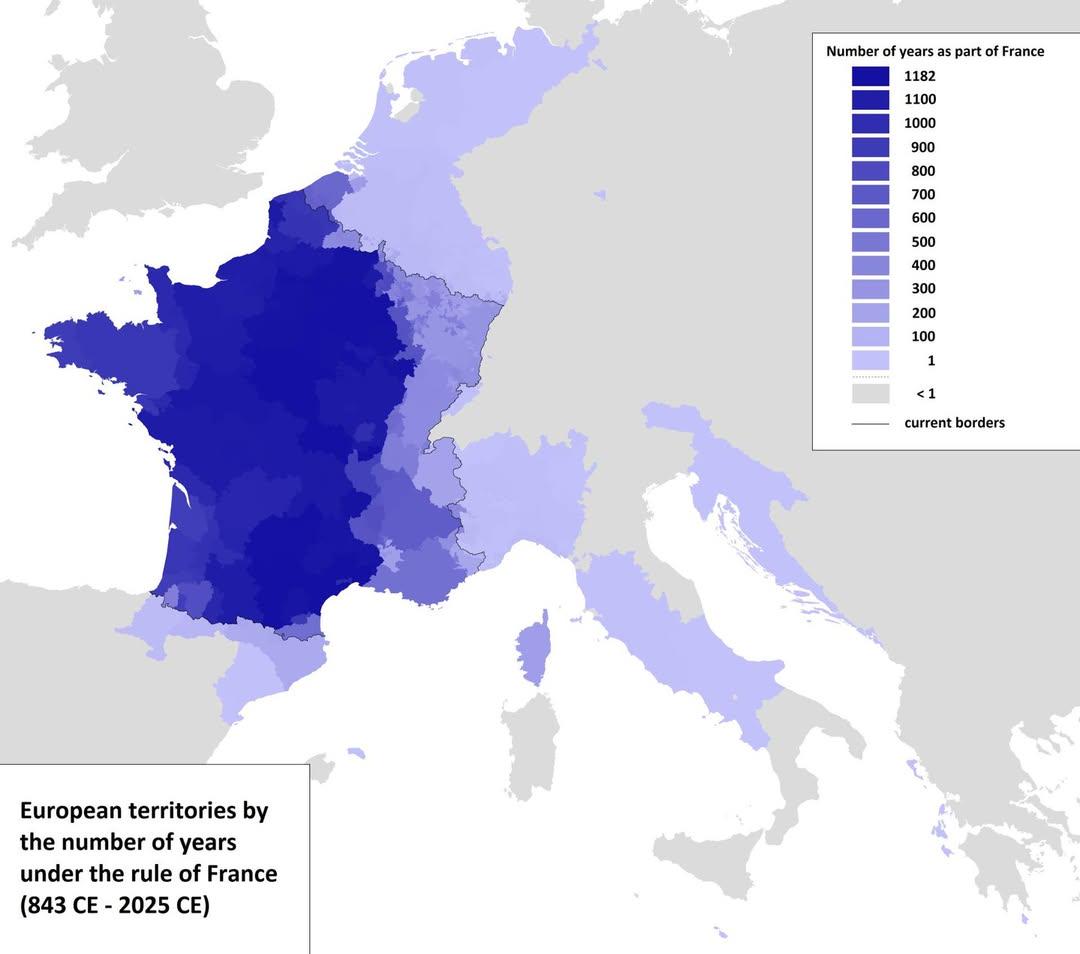
What This Map Shows
The visualization titled 'Map of European Territories By The Number of Years Spent Being Part of France' offers a comprehensive look at how long various regions in Europe have been integrated into France. This map is particularly interesting as it highlights the historical complexities of territorial changes and the evolution of national boundaries over centuries. By analyzing the time each territory has spent as part of France, we can glean insights into the geopolitical history of Europe and the enduring impacts of colonialism, wars, and treaties.
Deep Dive into French Territorial History
Interestingly, France's expansion and contraction of territory have been influenced by a multitude of factors including military conquests, diplomatic negotiations, and cultural assimilation. For instance, regions like Alsace and Lorraine have been under French control for varying lengths of time, influenced heavily by the outcomes of key conflicts such as the Franco-Prussian War and World War I. Alsace, which has vacillated between German and French control, showcases how territorial changes can lead to significant cultural and linguistic shifts.
The map identifies territories that have been part of France for as long as several centuries, such as Corsica, which became a French territory in 1768. In contrast, regions like Nice and Savoy were annexed relatively recently in 1860. This timeline reflects not only territorial ambitions but also the changing nature of European alliances and enmities.
Moreover, the significance of overseas territories cannot be overlooked. For example, regions like Réunion and Martinique have been part of France since the 17th century, showcasing how colonial expansion extended France’s reach beyond the European continent. These territories contribute to France's demographic diversity and economic resources, as they reflect a blend of cultures and traditions from both Europe and the wider world.
Regional Analysis
Examining the map reveals distinct patterns across different regions. In northern Europe, territories such as Alsace and Lorraine have a complex history of shifting allegiances, often shaped by their proximity to Germany. The unique blend of French and German cultural influences is evident in the local dialects, cuisine, and architecture.
Conversely, southern territories like Provence and Languedoc have maintained a more stable connection to France for centuries, showcasing a rich heritage that has significantly influenced French culture. The Mediterranean climate in these areas has fostered a vibrant agricultural sector, contributing to France's economy.
Interestingly, the overseas territories present a contrasting narrative. For instance, Guadeloupe and Martinique have been integral parts of France for over 350 years, yet they face distinct challenges related to economic dependency on mainland France and the impact of climate change. The historical context of these territories illustrates the complexities of identity and belonging within a larger national framework.
Significance and Impact
Understanding the historical context of these territories is crucial for comprehending contemporary France. The long-standing ties between regions and the nation have led to a mixture of identities, cultural exchanges, and economic dependencies. This topic matters not just for historians but also for policymakers and citizens alike. As we navigate current trends like globalization, the impact of migration, and regional autonomy movements, the legacy of France's territorial history is more relevant than ever.
Moreover, with the rise of regionalism across Europe, there are ongoing discussions about the future of these territories. Have you noticed how debates about autonomy and cultural preservation are becoming more prominent? The historical ties shown on the map play a critical role in these conversations, influencing how citizens view their identities in relation to both their local regions and the French state.
In conclusion, the 'Map of European Territories By The Number of Years Spent Being Part of France' serves as a visual reminder of the intricate history that shapes modern Europe. It invites us to reflect on how past territorial dynamics continue to influence present-day realities, and it challenges us to think about the future of these regions within the broader context of European integration and national identity.
Visualization Details
- Published
- September 11, 2025
- Views
- 74
Comments
Loading comments...