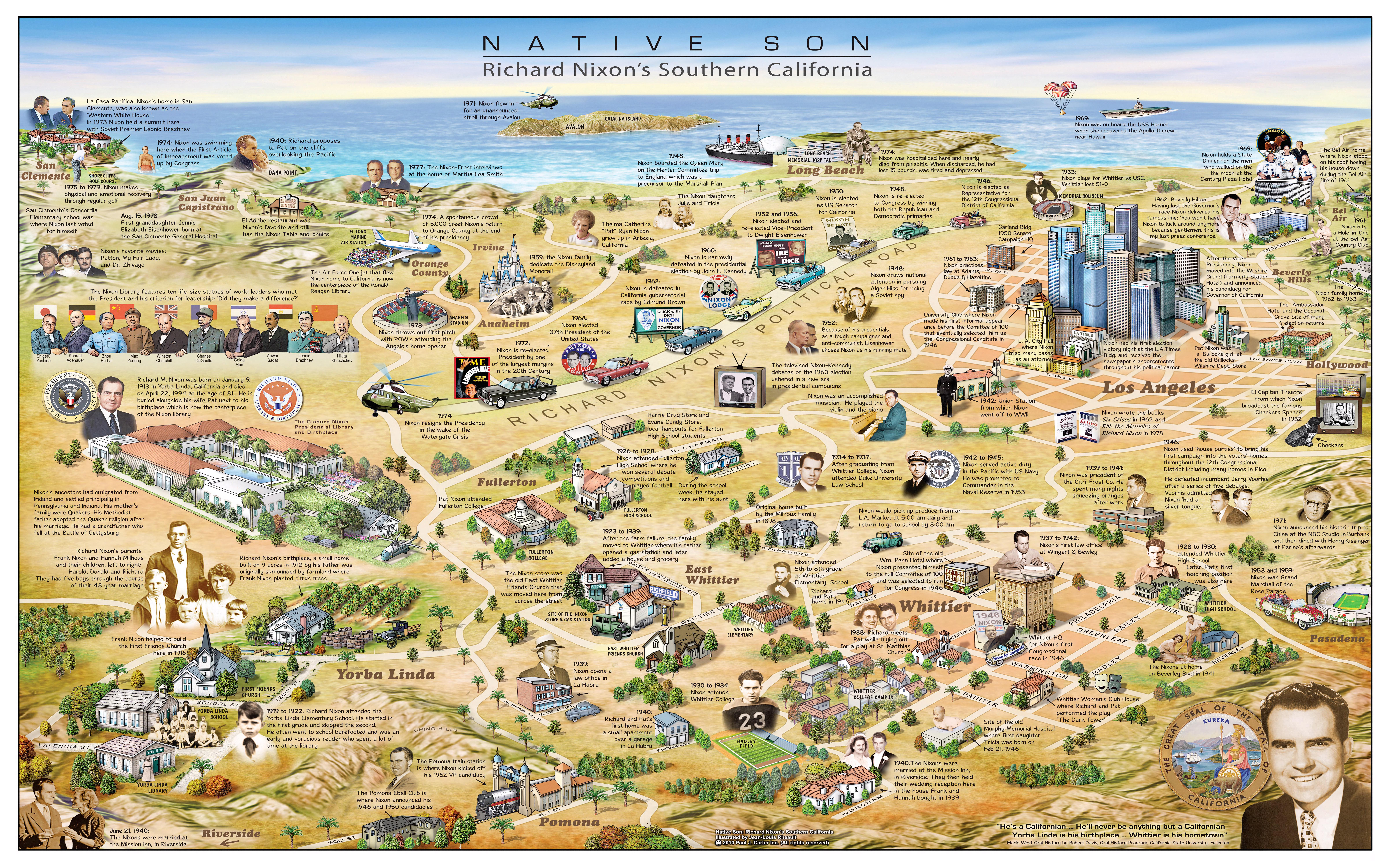
Richard Nixon's Southern California Map


David Chen
Data Visualization Specialist
David Chen is an expert in transforming complex geographic datasets into compelling visual narratives. He combines his background in computer science ...
Geographic Analysis
What This Map Shows
The map titled "Native Son - Richard Nixon's Southern California" by Paul Carter and Jean-Louis Rheault provides a detailed look at the geographical and cultural landscape that shaped Richard Nixon's early life and political career. Displaying key locations such as his childhood home in Yorba Linda, his high school, and other significant landmarks, this visualization illustrates how the Southern California region influenced Nixon's identity and political ideology. But rather than just focusing on Nixon himself, the map opens up a conversation about the broader historical and geographical context of Southern California during the early to mid-20th century.
Deep Dive into Southern California's Historical Landscape
Southern California is a region marked by its unique geographic features and diverse cultural backdrop. It has long been a melting pot of different cultures, primarily due to its favorable climate, which attracts a wide demographic. Interestingly, the area experienced rapid growth during the early 1900s, fueled by the arrival of the railroad and later, the development of the aerospace and entertainment industries. This growth not only transformed the landscape but also shaped the socio-political dynamics of the area.
So, what factors contributed to the rise of Southern California as a significant player in American politics? One of the most impactful elements was the post-World War II economic boom. This period saw a massive influx of people moving to the region, drawn by job opportunities and the allure of a suburban lifestyle. The population surged, and with it, the demand for infrastructure, housing, and public services. As cities expanded, so did the political influence of Southern California, leading to its emergence as a crucial battleground for political parties.
Moreover, the cultural landscape of Southern California has played a pivotal role in shaping its political leanings. With diverse communities, including a strong Latino presence, the region has often been at the forefront of social movements—from civil rights to immigration reform. Nixon, who grew up in this environment, was influenced by these dynamics, which would later impact his policies as President.
Interestingly, Nixon's upbringing in Yorba Linda, a small community, contrasts sharply with the rapid urbanization that Southern California underwent. This juxtaposition highlights how Nixon’s formative years were steeped in the values of small-town America, even as he navigated the complexities of a burgeoning urban landscape.
Regional Analysis
When we break down the map by regions, several contrasting areas emerge. For instance, Yorba Linda, Nixon's hometown, is emblematic of the suburban ideal that many Americans aspired to in the mid-20th century. It offers a snapshot of middle-class life, with its tree-lined streets and community-centric atmosphere. However, just a short drive away in Los Angeles, the narrative shifts dramatically. This bustling metropolis, a hub of entertainment and political activism, was the backdrop for Nixon's later career.
Northern Los Angeles County, including areas like Pasadena and Burbank, played critical roles in shaping Nixon's political strategies. The region's diverse electorate meant that Nixon had to navigate various interests and issues that were often at odds with one another. For instance, while suburban voters may have favored law and order policies, urban voters were increasingly advocating for social justice and equality. This dichotomy is crucial in understanding the challenges Nixon faced and how it influenced his political decisions.
Interestingly, the coastal cities of Orange County, which are depicted on the map, have historically leaned Republican, contributing to Nixon's political base. However, the demographic shifts in recent years have led to a more complex political landscape, where traditional voting patterns are being challenged. Analyzing these regional differences provides valuable context for understanding Nixon's strategies and the evolving political climate of Southern California.
Significance and Impact
So, why does the geography of Richard Nixon's Southern California matter today? Understanding this region's historical and political context is crucial for grasping the current political climate in the United States. Southern California remains a microcosm of the broader national landscape, where issues like immigration, economic disparity, and social justice continue to be hotly debated.
Furthermore, as demographics shift and political alignments evolve, the lessons from Nixon's era offer insights into contemporary political strategies. For instance, how Nixon navigated the complexities of a diversifying electorate can inform current politicians as they face similar challenges.
In conclusion, the map of "Native Son - Richard Nixon's Southern California" is more than just a visualization of a political figure's life; it encapsulates the intricate relationship between geography, culture, and politics. It serves as a reminder that the spaces we inhabit profoundly shape our identities and political ideologies. As we look to the future, understanding these dynamics will be essential in addressing the challenges that lie ahead for the region and the nation as a whole.
Visualization Details
- Published
- September 11, 2025
- Views
- 68
Comments
Loading comments...