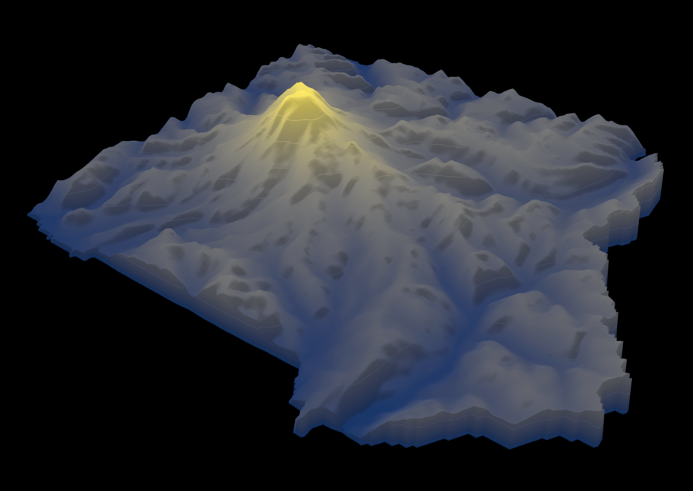
Height Map of Mount Rainier National Park


Alex Cartwright
Senior Cartographer & GIS Specialist
Alex Cartwright is a renowned cartographer and geographic information systems specialist with over 15 years of experience in spatial analysis and data...
Geographic Analysis
What This Map Shows
The height map of Mount Rainier National Park provides a detailed visualization of the elevation changes within this iconic national park. By using color gradients to represent different elevations, this map allows viewers to easily identify the towering peaks, lush valleys, and rugged terrain that characterize the park's diverse landscape. The map is particularly useful for understanding the topography of Mount Rainier, which stands at an impressive 14,411 feet, making it the highest peak in Washington State and an active stratovolcano.
Deep Dive into Mount Rainier's Topography
Mount Rainier National Park is a geological marvel, shaped by volcanic activity and glacial processes. The park encompasses a vast area of approximately 369 square miles, featuring not only the prominent Mount Rainier but also a range of other geological features, including subalpine meadows, deep river valleys, and numerous glaciers. Interestingly, the elevation changes across the park are quite dramatic; for example, the lowest point in the park is at about 1,000 feet, while the summit of Mount Rainier reaches 14,411 feet.
The significant elevation gradient within the park creates distinct ecosystems and climates. As you ascend from the park's base to its peak, you transition through various vegetation zones. At lower elevations, you encounter dense forests dominated by Douglas fir, western red cedar, and hemlock. Moving higher, these forests give way to subalpine meadows rich with wildflowers, such as the vibrant avalanche lily and the delicate lupine. Finally, at the highest elevations, conditions become harsh, resulting in a barren, rocky landscape where only the hardiest of organisms can survive.
The glaciers on Mount Rainier are particularly noteworthy. The park is home to over 25 major glaciers, including the Emmons Glacier, which is the largest glacier by volume in the contiguous United States. Glaciers play a crucial role in the park's hydrology, feeding rivers and streams that support diverse wildlife and plant life. However, climate change poses a significant threat to these glaciers. Studies have shown that Mount Rainier's glaciers are retreating at alarming rates, which may have far-reaching impacts on regional water resources and ecosystems.
Regional Analysis
When analyzing the height map, we can observe distinct regions within Mount Rainier National Park that showcase varied topographic features. For instance, the subalpine region located between approximately 5,000 and 7,000 feet is characterized by rolling hills and vibrant wildflower meadows. Popular areas like Paradise are located here, renowned for their stunning views and abundant summer wildflower displays. In contrast, the alpine zone above this elevation presents a much harsher environment, where steep cliffs and rocky outcrops dominate the landscape, creating challenges for both flora and fauna.
As we look further into the park’s valleys, such as the Nisqually and Carbon rivers, we notice how the elevation influences the climate and ecosystems in these areas. The Nisqually River, originating from the Nisqually Glacier, supports a rich array of wildlife and is a critical water source for the surrounding areas. In contrast, the Carbon River region is often shrouded in mist, with lush forests that thrive in the cooler, wetter climate.
Significance and Impact
Understanding the height and topography of Mount Rainier National Park is essential not only for appreciating its natural beauty but also for recognizing the ecological and hydrological dynamics at play. The park serves as a key habitat for a variety of species, including black bears, elk, and numerous bird species. Moreover, it plays a vital role in water supply for surrounding communities. The park's glaciers are a critical source of meltwater, especially during the dry summer months.
However, as climate change continues to impact our planet, the future of Mount Rainier's glaciers and ecosystems remains uncertain. Projections indicate that without significant reductions in greenhouse gas emissions, the glaciers could shrink drastically by the end of the century, leading to changes in water availability and ecosystem health. This highlights the importance of conservation efforts and the need for ongoing research to monitor these changes.
In conclusion, the height map of Mount Rainier National Park is more than just a representation of elevation; it is a powerful tool for understanding the park's complex geography and the vital ecological processes that sustain it. As we continue to study and appreciate this national treasure, it is imperative that we also advocate for its protection and the preservation of its unique landscapes for future generations to enjoy.
Visualization Details
- Published
- September 7, 2025
- Views
- 92
Comments
Loading comments...