Water Cycle Journey Map of South Asia

Marcus Rodriguez
Historical Geography Expert
Marcus Rodriguez specializes in historical cartography and geographic data analysis. With a background in both history and geography, he brings unique...
Geographic Analysis
What This Map Shows
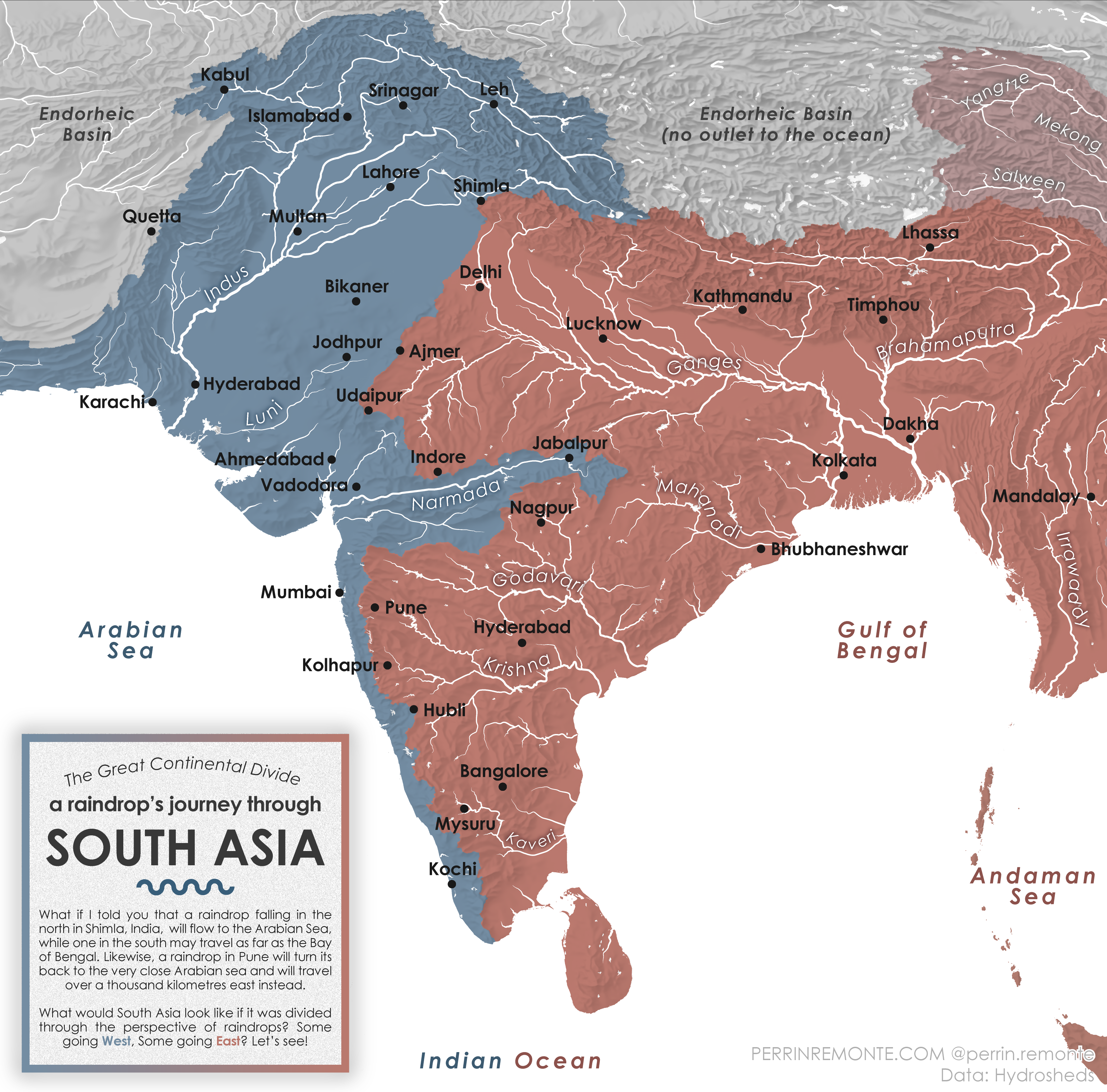
The visualization titled "A Raindrop's Journey through South Asia" provides an intriguing look at the water cycle within this diverse and complex region. It tracks the journey of a raindrop from its initial fall to its eventual return to the atmosphere, highlighting key geographical features such as rivers, lakes, and mountainous terrains. This map serves as a reminder of the interconnectedness of ecosystems and the vital role water plays in sustaining life across South Asia.
Deep Dive into the Water Cycle
Water is the lifeblood of our planet, and nowhere is this more apparent than in South Asia. The water cycle, also known as the hydrological cycle, is the continuous movement of water on, above, and below the surface of the Earth. It encompasses processes such as evaporation, condensation, precipitation, and runoff. In South Asia, the diverse climatic conditions and topographical variations create a unique tapestry of water systems that are essential for agriculture, drinking water supply, and ecosystem health.
Interestingly, South Asia experiences a monsoon climate, characterized by a distinct wet season and dry season. During the summer months, warm air from the Indian Ocean brings heavy rainfalls, transforming the landscape and replenishing rivers and lakes. For instance, the Ganges River, which originates in the Himalayas, relies heavily on monsoonal rains to sustain its flow, affecting millions of people who depend on it for irrigation and drinking water.
The journey of a raindrop in South Asia often begins in the towering mountains of the Himalayas, where snowmelt and rainfall feed into rivers that carve through valleys and plains. For example, the Indus River, one of the longest rivers in Asia, is fed by glacial melt and monsoon rains, creating a lifeline for agricultural regions in Pakistan. The river basin is particularly significant, as it supports one of the most densely populated areas in the world.
Moreover, the water cycle in South Asia is not just about rivers. Lakes like the Dal Lake in Kashmir and the vast Sundarbans mangrove forests are also crucial components of the ecosystem. These areas act as natural water reservoirs, absorbing excess rainfall and providing habitats for diverse wildlife. Interestingly, the interconnectedness of these water bodies plays a critical role in regulating local climates, as they help to cool the surrounding areas and influence precipitation patterns.
However, the water cycle in South Asia is increasingly threatened by climate change, deforestation, and urbanization. The increasing frequency and intensity of extreme weather events, such as floods and droughts, disrupt this delicate balance. For instance, in recent years, parts of India and Bangladesh have experienced catastrophic flooding due to heavier-than-normal monsoon rains, leading to significant displacement of communities and agricultural losses.
Regional Analysis
When we break down the water cycle as depicted in the map, we can observe significant regional variations throughout South Asia. In the northern regions, such as Nepal and northern India, the Himalayas serve as a massive catchment area. Here, the snowmelt and rain feed major rivers like the Brahmaputra and Ganges, essential for supporting agriculture in the Indo-Gangetic Plain.
Conversely, in the southern parts of India, the Western and Eastern Ghats influence rainfall patterns differently. The Western Ghats receive heavy rainfall due to orographic lift, creating lush biodiversity and rich agricultural lands. In contrast, the eastern coast experiences a rain shadow effect, leading to drier conditions in certain areas. This difference can be observed in the contrasting agricultural practices and water management strategies employed in these regions.
Interestingly, Bangladesh, situated at the confluence of several major rivers, faces unique challenges. The delta region is prone to flooding during the monsoon season, and its residents have adapted to this cyclical nature of water. The map highlights how interconnected rivers and tributaries create a complex network that supports the region's agriculture and fisheries, essential for the local economy.
Significance and Impact
Understanding the journey of a raindrop through South Asia is crucial for several reasons. Water resources in this region are under immense pressure due to population growth, economic development, and climate change. As urban areas expand, the demand for water increases, leading to potential conflicts over water rights and access.
Moreover, the ongoing impacts of climate change are projected to exacerbate existing vulnerabilities. Increasing temperatures and changing precipitation patterns threaten traditional farming practices and food security, especially in regions reliant on predictable monsoon rains. What's fascinating is how communities are adapting to these changes, employing methods such as rainwater harvesting and conservation agriculture to mitigate water scarcity.
In conclusion, the journey of a raindrop across South Asia encapsulates the intricate relationship between geography, climate, and human activities. By studying this map, we not only gain insights into the water cycle but also highlight the critical issues surrounding water management and sustainability in a region that is vital to millions of lives.
Visualization Details
- Published
- September 7, 2025
- Views
- 70
Comments
Loading comments...