Canada vs Europe Map Comparison

Alex Cartwright
Senior Cartographer & GIS Specialist
Alex Cartwright is a renowned cartographer and geographic information systems specialist with over 15 years of experience in spatial analysis and data...
Geographic Analysis
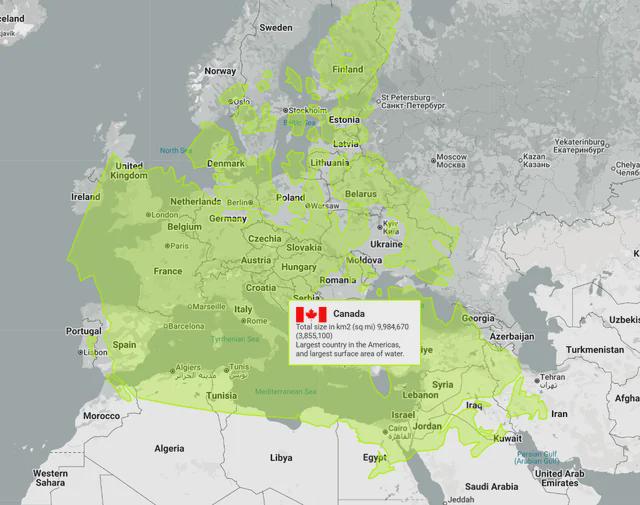
What This Map Shows\nThis intriguing map visually juxtaposes Canada over Europe, demonstrating just how vast Canada really is. The visualization highlights that if Canada were to be placed on the European continent, countries like Morocco, Iran, and even Northern Finland would fall within the same geographical bounds. This striking image prompts us to consider not only the sheer landmass of Canada but also the diverse demographics and cultural landscapes of both regions.
Deep Dive into Canada’s Geography\nCanada, the second-largest country in the world by total area, covers approximately 9.98 million square kilometers. This immense size encompasses a variety of geographical features, including mountains, forests, lakes, and tundra. One of the fascinating aspects of Canada’s geography is its climate zones, ranging from temperate in the coastal regions to subarctic and arctic in the north.
Interestingly, Canada is home to the longest coastline in the world, measuring over 202,080 kilometers. This extensive coastline is a critical factor in the country's climate and biodiversity, influencing everything from weather patterns to the types of ecosystems found within its borders. The Great Lakes, which Canada shares with the United States, are a vital part of the country’s freshwater resources, accounting for about 20% of the world's surface freshwater supply.
Moreover, Canada is characterized by its distinct landforms, such as the Rocky Mountains in the west and the Canadian Shield, which covers much of eastern and central Canada. These geographical features significantly affect human settlement patterns, with most Canadians living in urban areas near the U.S. border. The population density is strikingly low in the northern regions, where harsh climates and remote locations make habitation challenging.
Regional Analysis\nWhen comparing the regions depicted in the map, several interesting contrasts emerge. In the southern parts of Canada, such as Ontario and British Columbia, urban centers like Toronto and Vancouver thrive, boasting diverse populations and economies driven by technology, finance, and natural resources. In contrast, the northern territories, including Yukon and Nunavut, have a much lower population density, with communities often relying on traditional practices and resources.
For instance, if we consider the hypothetical scenario where Canada covers parts of Europe, the cultural implications are profound. Imagine a region where the bustling streets of Moroccan cities, the rich cultural history of Iran, and the quiet, serene landscapes of Northern Finland coexist. This juxtaposition highlights not only the geographical expanse of Canada but also the diversity of people and cultures that could intersect in such a scenario.
Significance and Impact\nSo why does understanding this geographical comparison matter? Firstly, it emphasizes the importance of geography in shaping national identity, culture, and economics. The vast expanse of Canada allows for a multitude of natural resources, which play a crucial role in its economy and global standing. Moreover, the climate and geography influence everything from agriculture to transportation networks.
Moreover, as climate change continues to impact geographical landscapes worldwide, understanding the geographical dynamics between vast nations like Canada and densely populated regions in Europe becomes increasingly relevant. It raises questions about resource distribution, migration patterns, and international relations. For instance, how might populations shift in response to climate events in one region affecting another?
In conclusion, this map serves as a powerful reminder of the sheer scale of Canada and the intricate relationships between geography, culture, and economy. It invites us to think critically about how geography shapes our world, and what it might mean for future generations as we face global challenges together.
Visualization Details
- Published
- August 23, 2025
- Views
- 192
Comments
Loading comments...