Topographic Relief Map of Switzerland

Marcus Rodriguez
Historical Geography Expert
Marcus Rodriguez specializes in historical cartography and geographic data analysis. With a background in both history and geography, he brings unique...
Geographic Analysis
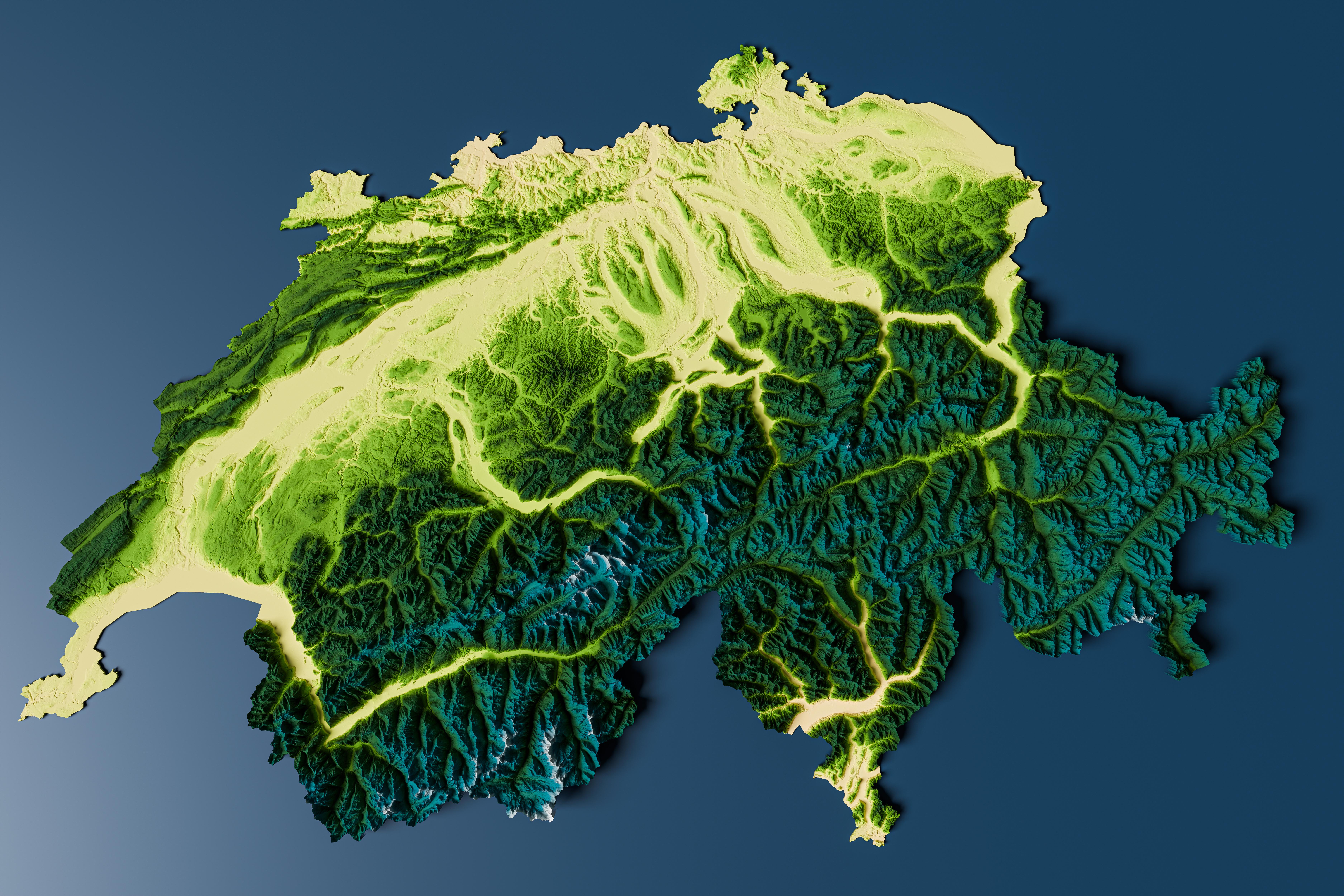
What This Map Shows\nThe beautiful colorized and rendered relief map of Switzerland provides a striking top-down view of one of the most picturesque countries in Europe. This visualization vividly displays the complex interplay of mountains, valleys, and plains, highlighting the diverse topography that characterizes Switzerland's landscape. The map uses color gradients to indicate elevation, allowing viewers to easily discern the dramatic changes in altitude across the country.
Deep Dive into Switzerland's Topography\nSwitzerland's topography is a fascinating subject, shaped by its unique geological history and position within the Alps. The country is renowned for its mountainous terrain, with the Swiss Alps encompassing roughly 65% of the total land area. The peaks of these mountains, including the iconic Matterhorn and Jungfrau, soar to impressive heights, creating not only stunning vistas but also distinct ecological zones.
Interestingly, the topographical variation influences climate, biodiversity, and human settlement patterns. The highest peaks, above 4,000 meters, are often capped with glaciers, contributing to Switzerland's freshwater resources as they melt and feed into rivers and lakes. In contrast, the lower regions, such as the Swiss Plateau, present a more temperate climate, which is conducive to agriculture and urban development. This duality of high-altitude and lowland environments presents a unique blend of ecosystems, from alpine meadows to lush river valleys.
The Swiss landscape is not just about mountains; the country is interspersed with numerous lakes, including Lake Geneva and Lake Lucerne. These bodies of water play a critical role in the local climate and serve as hubs for recreation and tourism. The lakes, often surrounded by steep, picturesque hills, are a reminder of the glacial activity that shaped this region thousands of years ago.
Moreover, Switzerland's intricate river systems, such as the Rhine and Aare, carve their way through the valleys, further contributing to the rich biodiversity. The rivers, fed by melting snow and glaciers, also serve vital roles in transportation and hydroelectric power generation, underpinning the Swiss economy. Did you know that approximately 60% of Switzerland's electricity comes from hydropower? This reliance on natural watercourses showcases how topography directly impacts energy production.
Regional Analysis\nLet's take a closer look at the distinct regions highlighted on the map. The southern part of Switzerland, known as Ticino, is characterized by its Mediterranean-like climate due to its lower elevation and proximity to Italy. This region boasts lush vegetation and is famous for its charming lakeside towns. In contrast, the northern regions, including the Jura mountains, are less elevated but still significant in terms of biodiversity and geological history.
The central region, often referred to as the Swiss Plateau, is where most of the population resides. Cities like Zurich and Bern are situated here, benefiting from the relatively flatter terrain that is more suitable for urban development. Interestingly, the demographic patterns reflect the geography, as people tend to inhabit areas that are easier to access and develop.
What's fascinating is that the elevation also influences the cultural aspects of the regions. For instance, the high alpine regions have retained distinct traditions and lifestyles that are closely tied to their rugged terrain, while the urbanized central regions reflect a more modern, cosmopolitan Swiss culture.
Significance and Impact\nUnderstanding Switzerland's topography is crucial for various reasons. Firstly, it impacts environmental conservation efforts, as certain areas are more vulnerable to climate change and ecological disruption than others. The melting glaciers, for instance, raise concerns about water supply and natural habitats.
Additionally, tourism plays a significant role in the Swiss economy, with millions of visitors drawn to the breathtaking landscapes each year. Sustainable tourism practices are becoming increasingly important in preserving these natural wonders while supporting local economies.
Finally, as global discussions about climate change and renewable energy intensify, Switzerland's reliance on its topographical features for hydropower presents both a challenge and an opportunity. The balance between harnessing natural resources and protecting the environment will be pivotal in shaping the future of this stunning country.
In conclusion, the topographic relief map of Switzerland not only serves as a beautiful visualization of its diverse landscapes but also encapsulates the intricate relationship between geography, ecology, and human life in this remarkable region.
Visualization Details
- Published
- August 16, 2025
- Views
- 98
Comments
Loading comments...