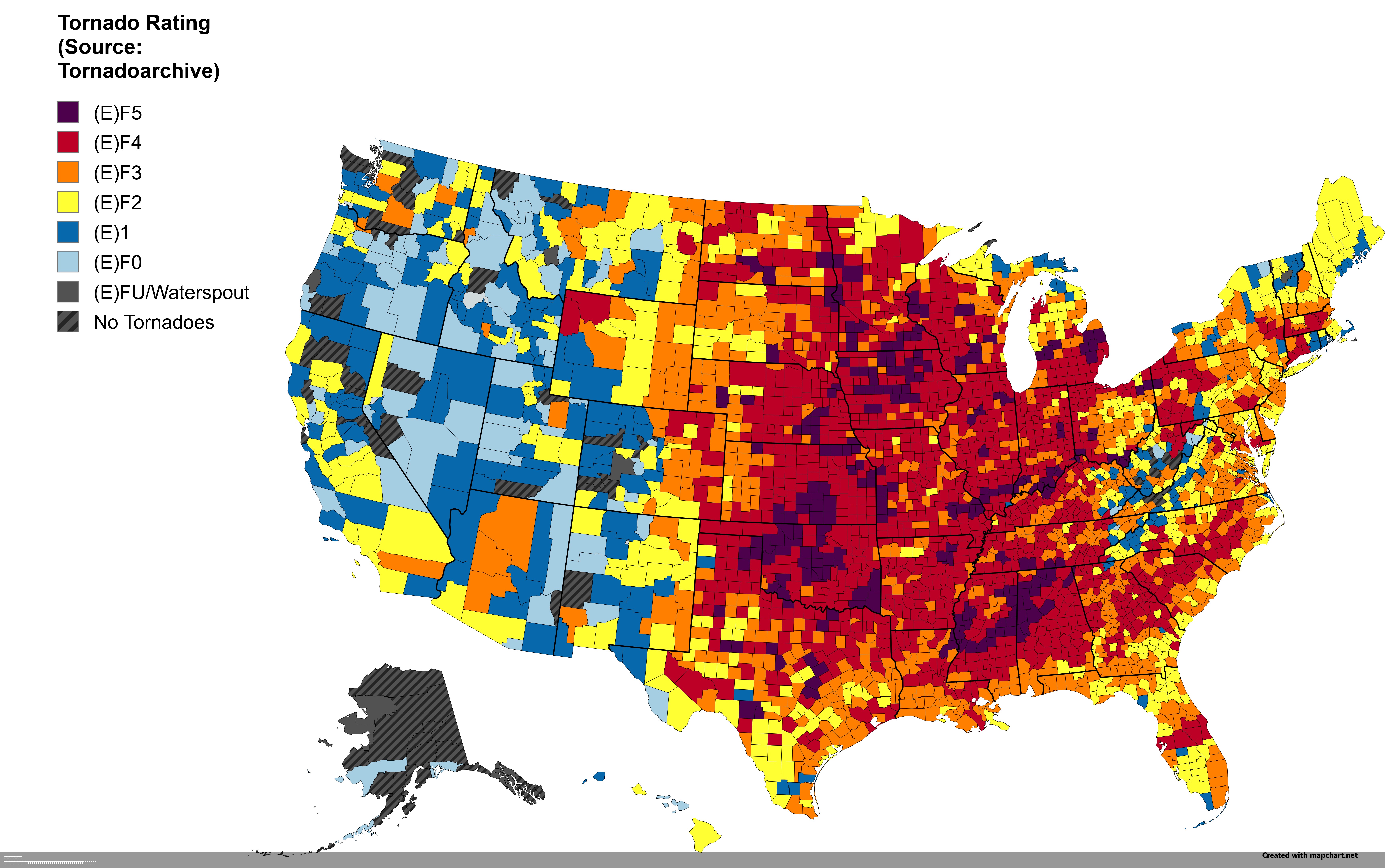
Strongest Tornado by US County Map

David Chen
Data Visualization Specialist
David Chen is an expert in transforming complex geographic datasets into compelling visual narratives. He combines his background in computer science ...
Geographic Analysis
What This Map Shows
This intriguing visualization displays the strongest tornado recorded in each U.S. county. Tornadoes, nature's most violent storms, vary dramatically across the country, and this map helps us understand which counties have experienced the most intense tornadoes. This information is crucial for understanding the risk and preparedness necessary for residents and planners alike.
Deep Dive into Tornadoes
Tornadoes are rapidly rotating columns of air that extend from a thunderstorm to the ground. They are classified on the Enhanced Fujita Scale, which ranges from EF0 (weakest) to EF5 (strongest), based on the damage they cause. Interestingly, the U.S. experiences more tornadoes than any other country, with an average of over 1,000 tornadoes occurring annually. This high frequency can be attributed to the unique geography of the central United States, often referred to as "Tornado Alley."
The conditions necessary for tornado formation include warm, moist air at the surface and cooler, dry air aloft. When these air masses meet, they create instability that can lead to severe thunderstorms and eventually tornado development. Interestingly, the strongest tornadoes, those rated EF4 and EF5, are relatively rare but can have devastating effects. For instance, an EF5 tornado can produce winds exceeding 200 miles per hour, capable of leveling well-built homes and uprooting trees.
Data from the National Oceanic and Atmospheric Administration (NOAA) indicates that the peak tornado season varies by region; for instance, in the southern states, tornadoes are most common in the spring, while in the northern states, they are more prevalent during the summer months. The physical geography of a region can also influence tornado occurrences. Areas with flat plains, such as those found in parts of Oklahoma and Kansas, are particularly susceptible to tornado formation due to the lack of geographical barriers that can disrupt airflow.
Interestingly, the strongest tornadoes tend to occur in the Great Plains, where the conditions for their formation are most favorable. In contrast, coastal areas and mountainous regions tend to see fewer tornadoes due to their geographical features. The strongest tornado recorded in U.S. history occurred in 2011 in Joplin, Missouri, where an EF5 tornado tragically claimed 158 lives and caused over $2.8 billion in damages.
Regional Analysis
When analyzing the map, it becomes clear that certain regions have a higher concentration of strong tornadoes. For example, states like Texas, Oklahoma, and Kansas dominate the map with numerous counties marked by EF4 and EF5 tornadoes. This prevalence highlights the importance of preparedness in these regions.
In Texas, counties such as Tarrant and Dallas have experienced EF4 tornadoes, while Oklahoma's counties like Oklahoma and Cleveland have been hit by EF5 tornadoes. This difference in tornado strength and frequency showcases the variability in tornado behavior, influenced by local climatic and topographical factors.
In the Midwest, counties in Illinois and Indiana have also recorded severe tornadoes, but these tend to be slightly less intense compared to those found further south. However, the frequency of tornadoes can lead to a cumulative risk that is significant for residents in these areas. The Southeast, while less known for tornadoes, still has pockets of strong tornado activity, particularly in Alabama and Mississippi, where EF3 and EF4 tornadoes have left their mark.
Significance and Impact
Understanding tornado patterns is critical for mitigating risks associated with these severe weather events. Tornado preparedness can significantly reduce the loss of life and property damage. Communities in high-risk areas often implement tornado warning systems and conduct regular safety drills to prepare for potential tornado outbreaks.
Moreover, advancements in meteorological technology, such as Doppler radar and satellite imagery, have improved tornado prediction capabilities. However, despite these advancements, the nature of tornadoes remains unpredictable. As climate change continues to shape our weather patterns, researchers are exploring how shifts in climate may influence tornado frequency and intensity in the future. Interestingly, some studies suggest that while the overall number of tornadoes may not increase, the proportion of stronger tornadoes could rise.
In conclusion, the map of the strongest tornado in every U.S. county is not just a geographical curiosity; it serves as a vital tool for understanding the risks and realities of living in tornado-prone areas. By examining the data, we can appreciate the power of these storms and the importance of preparedness and resilience in the face of nature's fury.
Visualization Details
- Published
- August 7, 2025
- Views
- 132
Comments
Loading comments...