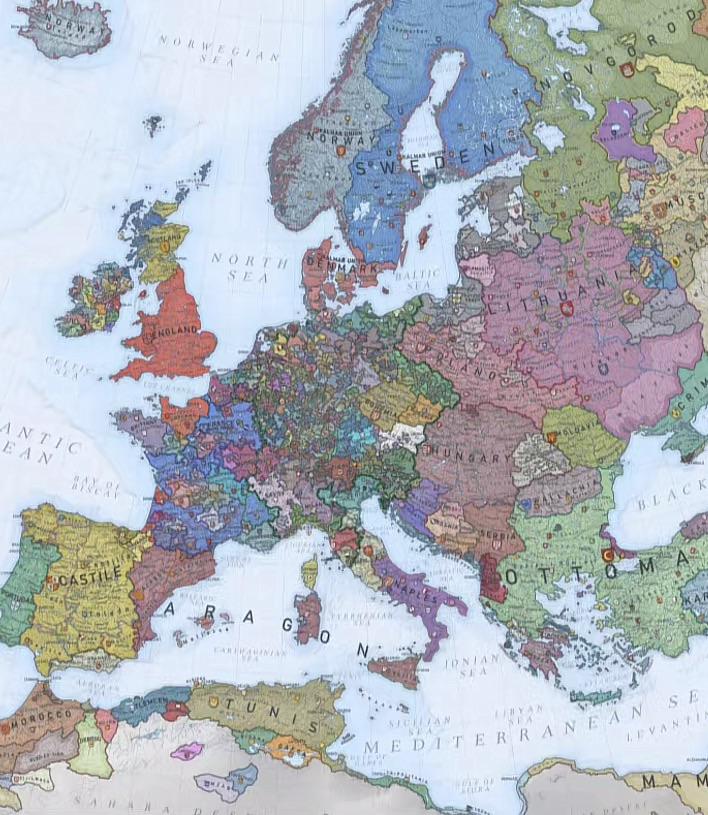
Political Map of Europe in the 1400s

David Chen
Data Visualization Specialist
David Chen is an expert in transforming complex geographic datasets into compelling visual narratives. He combines his background in computer science ...
Geographic Analysis
What This Map Shows
The map titled "Europe in the 1400s" provides a detailed political overview of the continent during a pivotal period in its history. It showcases the territorial divisions, kingdoms, and empires that defined Europe at the time, capturing the complex relationships between various states. This visualization serves as a window into a time of both conflict and cultural flourishing, highlighting the shifting borders and political dynamics that shaped modern Europe.
Deep Dive into Political Territories of the 1400s
The 15th century was a tumultuous time for Europe, characterized by the rise and fall of empires, the redrawing of borders, and the emergence of nation-states. During this period, Europe was not only a patchwork of kingdoms but also a stage for significant historical events that would influence the continent for centuries to come.
At the start of the 1400s, the Holy Roman Empire dominated central Europe, encompassing a vast array of duchies and principalities. However, its power was waning as regional leaders began asserting their independence. The fragmentation of authority was evident, with territories like Bohemia and Austria beginning to carve out their own identities.
In the west, France and England were embroiled in the Hundred Years' War, a conflict that significantly impacted their political landscapes. This war not only defined territorial claims but also fostered a growing sense of national identity among the populations.
Meanwhile, the Iberian Peninsula was witnessing the final phases of the Reconquista, as Christian kingdoms like Castile and Aragon united to capture Granada, the last Muslim stronghold in Spain. This unification laid the groundwork for the eventual emergence of Spain as a powerful nation-state.
Interestingly, the map also highlights the significant presence of the Ottoman Empire, which was expanding into southeastern Europe. By the end of the 1400s, the Ottomans had captured key territories, including Bosnia and parts of Hungary, signaling a shift in power dynamics that would lead to centuries of conflict between Christian and Muslim territories.
In Northern Europe, the Kalmar Union briefly united Denmark, Norway, and Sweden under a single monarch, but internal strife soon led to its dissolution. This period marked the beginning of the rise of individual Scandinavian kingdoms, each developing its unique identity and approach to governance.
The political landscape in Italy was particularly fragmented. Composed of city-states like Florence, Venice, and Milan, Italy was a hub of trade, art, and culture. The competition among these city-states not only fueled economic prosperity but also initiated the Renaissance, a cultural revival that would influence Europe for generations.
Regional Analysis
When examining the political divisions of Europe as depicted in this map, several regional variations emerge. In Western Europe, the nations of France and England were in a state of conflict, characterized by shifting alliances and territorial disputes. The outcome of the Hundred Years' War would eventually lead to the unification of France and the strengthening of its monarchy.
In contrast, Southern Europe showcased a more unified front with the rise of Spain. The completion of the Reconquista in 1492 not only marked a significant political achievement but also set the stage for Spanish exploration overseas.
Central and Eastern Europe, however, were marked by fragmentation. The Holy Roman Empire was a complex tapestry of semi-autonomous regions, while the Ottomans posed an ever-present threat to Eastern Europe. Countries like Poland and Hungary were struggling to maintain their independence amid external pressures.
Northern Europe, particularly the Scandinavian region, was beginning to see the seeds of national identities forming. The dissolution of the Kalmar Union allowed Denmark, Norway, and Sweden to pursue distinct paths, which would shape their future development.
Significance and Impact
Understanding Europe in the 1400s is crucial for grasping the historical context of contemporary European politics. The territorial divisions and power struggles of this era laid the groundwork for the modern nation-states we recognize today. The conflicts of the 15th century not only shaped borders but also influenced cultural and economic developments that resonate to this day.
What’s fascinating is how the political dynamics of the 1400s contributed to the rise of nationalism in subsequent centuries. As countries began to develop their unique identities, they also laid the groundwork for the modern concepts of citizenship and governance. The legacies of these early political entities continue to affect current European relations and policies.
In conclusion, the political map of Europe in the 1400s is more than just a depiction of borders; it is a representation of the complex interplay of power, culture, and identity that has shaped Europe into what it is today. As we reflect on this era, it’s clear that the events of the past still echo in the political landscape of modern Europe, reminding us of the intricate tapestry of history that binds us together.
Visualization Details
- Published
- October 26, 2025
- Views
- 24
Comments
Loading comments...