German Plans for Europe After WW1 Map

Alex Cartwright
Senior Cartographer & GIS Specialist
Alex Cartwright is a renowned cartographer and geographic information systems specialist with over 15 years of experience in spatial analysis and data...
Geographic Analysis
What This Map Shows
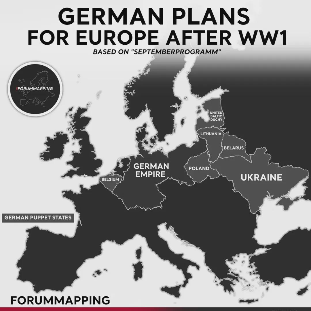
The map titled "German Plans for Europe After WW1" provides a visual representation of Germany's geopolitical ambitions following the end of World War I. It highlights the territorial adjustments and proposed borders that Germany envisioned, reflecting its aspirations to expand its influence and control over various regions in Europe.
Interestingly, this map is a crucial historical artifact that not only illustrates territorial claims but also encapsulates the political climate of post-war Europe—a landscape marked by upheaval, nationalistic fervor, and the quest for power. In the aftermath of the Treaty of Versailles in 1919, which imposed heavy reparations and territorial losses on Germany, these plans reveal the nation's desire to recover lost territories and assert its dominance in the region.
Deep Dive into German Territorial Aspirations
The end of World War I in 1918 was a pivotal moment in European history, marking the collapse of empires and the redrawing of national boundaries. Germany, once a formidable empire, faced significant territorial losses under the Treaty of Versailles. However, nationalist sentiments within Germany fueled ambitions to reclaim and expand its borders, leading to plans that are vividly illustrated in this map.
One of the key aspects of the map is the focus on regions such as the Saar Basin, which was rich in coal and industrial resources. Germany sought to regain this area, as it was critical for economic recovery. The map outlines how Germany envisioned incorporating the Saar into its territory, a desire that would later lead to significant political tensions in the 1920s and 1930s.
Additionally, the map indicates aspirations toward parts of Poland, particularly areas with substantial German-speaking populations. This reflects a broader trend of ethnic nationalism that was prevalent during the interwar period. The desire to unify German-speaking peoples, known as the "Volksgemeinschaft" concept, was a driving force behind these territorial ambitions. For instance, Silesia, which had a mixed population, was a region of contention. Interestingly, the map shows not only the areas Germany sought to reclaim but also its aggressive stance toward neighboring nations.
Moreover, the map hints at aspirations toward the Baltic states and even parts of Czechoslovakia. The notion of Lebensraum, or "living space," was gaining traction in German political discourse, which argued that Germany needed more territory for its growing population. The implications of these plans were far-reaching, ultimately contributing to the aggressive policies that led to World War II.
Regional Analysis
Examining the regions indicated on the map, we see distinct patterns of ambition and conflict. In the Saar Basin, for instance, the economic implications of control over coal resources cannot be overstated. This area was not just about territory; it was about economic survival for a nation facing the repercussions of war reparations.
Comparatively, the aspirations toward Silesia reveal a more complex ethnic narrative. The region had a diverse population, including Poles and Germans, which made it a focal point for nationalistic claims. The map's portrayal of these ambitions demonstrates how territorial disputes often intersect with ethnic identities, leading to lasting tensions in the region.
Looking further east, the aspirations toward the Baltic states reflect a strategic interest in controlling sea access and trade routes. The map illustrates how Germany viewed these territories not just as land but as vital links to bolster its economic and military power. However, these ambitions were met with resistance from both the local populations and other European powers, leading to conflicts that would shape the geopolitical landscape for decades.
Significance and Impact
Understanding the German plans for Europe after WW1 is essential for grasping the complexities of 20th-century European history. This map serves as a reminder of how the aftermath of one conflict can sow the seeds for future disputes. The territorial ambitions indicated on the map did not just disappear; they evolved into aggressive policies that contributed to the rise of fascism and ultimately led to the outbreak of World War II.
The implications of these ambitions can still be felt today. The map encapsulates the nationalistic fervor that characterized the interwar period, a phenomenon that continues to resonate in contemporary geopolitics. Have you noticed how nationalist movements often invoke historical grievances? This pattern reflects a cyclical nature of history where unresolved conflicts can resurface, leading to instability.
As we look at Europe today, the echoes of these territorial aspirations remind us of the importance of diplomacy and conflict resolution. The lessons learned from this tumultuous period are vital in preventing the repeat of history, making the study of such maps not just an academic exercise but a crucial endeavor for understanding our world.
Visualization Details
- Published
- October 23, 2025
- Views
- 16
Comments
Loading comments...