Political Map of Europe in 1328

Alex Cartwright
Senior Cartographer & GIS Specialist
Alex Cartwright is a renowned cartographer and geographic information systems specialist with over 15 years of experience in spatial analysis and data...
Geographic Analysis
What This Map Shows
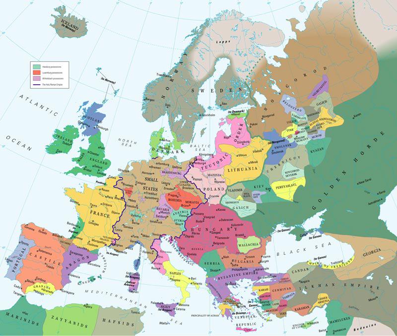
The "Map of Europe in 1328" provides a detailed depiction of the political landscape during the early 14th century. It exhibits the various kingdoms, principalities, and territories that comprised Europe at that time, showcasing borders, significant cities, and notable geographical features. This visualization serves as a valuable historical reference, allowing us to understand the political dynamics and territorial divisions that shaped the continent during this pivotal era.
Deep Dive into Medieval Political Geography
In 1328, Europe was a patchwork of rival states and emerging powers, each vying for dominance and territorial control. This period is particularly fascinating because it marks the transitional phase between the feudal system and the rise of centralized monarchies. Kingdoms like England, France, and the Holy Roman Empire were not just territorial entities; they were also battlegrounds for competing interests, both internal and external.
During this time, the Kingdom of France was on the rise, under the rule of the Capetian dynasty. Philip VI, who became king in 1328, began to consolidate power, setting the stage for the future Hundred Years’ War. Similarly, England, under Edward III, was beginning to assert its influence on the continent, leading to conflicts that would shape European history for generations.
Interestingly, smaller states and city-states also played crucial roles. The Italian peninsula was dotted with powerful city-states like Venice, Florence, and Genoa, each competing for economic dominance in trade and commerce. These city-states were not just political entities; they were cultural epicenters that fostered advancements in art and science, contributing to the Renaissance that would soon follow.
Another significant aspect of this map is the presence of the various principalities that made up the Holy Roman Empire. These territories were often politically fragmented, with a mix of dukes, counts, and bishops holding power. This fragmentation led to a complex web of allegiances and rivalries that defined Central Europe during this period.
Moreover, the Iberian Peninsula was undergoing its own transformation, with the Reconquista nearing its final stages as Christian kingdoms sought to reclaim territory from Muslim rule. By 1328, the Kingdom of Castile was growing in strength, while the Kingdom of Aragon was also expanding its influence, showcasing the diverse political landscape of the time.
Regional Analysis
When we look at specific regions, we can see distinct political characteristics. In Northern Europe, the kingdoms of Denmark and Sweden were establishing their territories, while the Hanseatic League began forming as a response to economic needs. This trade network allowed cities like Lübeck and Hamburg to flourish, highlighting how commerce influenced political boundaries.
In Southern Europe, the fragmented nature of the Italian states created a unique political environment. For instance, Venice's control over trade routes made it a significant power in the Mediterranean, often clashing with rival states such as the Papal States. The political interplay between these city-states not only shaped their borders but also fostered a rich cultural exchange that would impact European history.
Comparatively, Eastern Europe presented a different scenario. The Kingdom of Poland and the Grand Duchy of Lithuania were emerging as significant powers, while the fragmented states of the Balkans were still grappling with the influences from the Byzantine Empire and Ottoman incursions. The political landscape here was complex and often unstable, setting the stage for future conflicts and territorial disputes.
Significance and Impact
Understanding the political map of Europe in 1328 is crucial for grasping the complexities of European history. This era laid the groundwork for many modern nations and their borders. The tensions between emerging monarchies and feudal lords reflect ongoing struggles for power that resonate throughout history.
What's fascinating is how these borders have evolved, often as a result of war, diplomacy, or even cultural exchanges. Today, many of the nations that emerged from this fragmented political landscape still grapple with historical identities and territorial disputes.
Moreover, the map offers insights into how trade routes influenced political power dynamics. The rise of commerce and urban centers during this time foreshadowed the economic transformations that would come with the Renaissance and the Age of Exploration. As we delve into the historical implications of this map, we can draw parallels to contemporary issues, such as the ongoing debates about national sovereignty and the implications of economic alliances in our globalized world.
In conclusion, the "Map of Europe in 1328" is more than just a historical artifact; it is a window into a transformative period that shaped the continent's political, cultural, and economic landscape. By analyzing the map's details, we can gain a deeper appreciation for the complex tapestry that is European history and understand how it continues to influence our world today.
Visualization Details
- Published
- October 22, 2025
- Views
- 32
Comments
Loading comments...