Italy Land Cover Map 2024

Alex Cartwright
Senior Cartographer & GIS Specialist
Alex Cartwright is a renowned cartographer and geographic information systems specialist with over 15 years of experience in spatial analysis and data...
Geographic Analysis
What This Map Shows
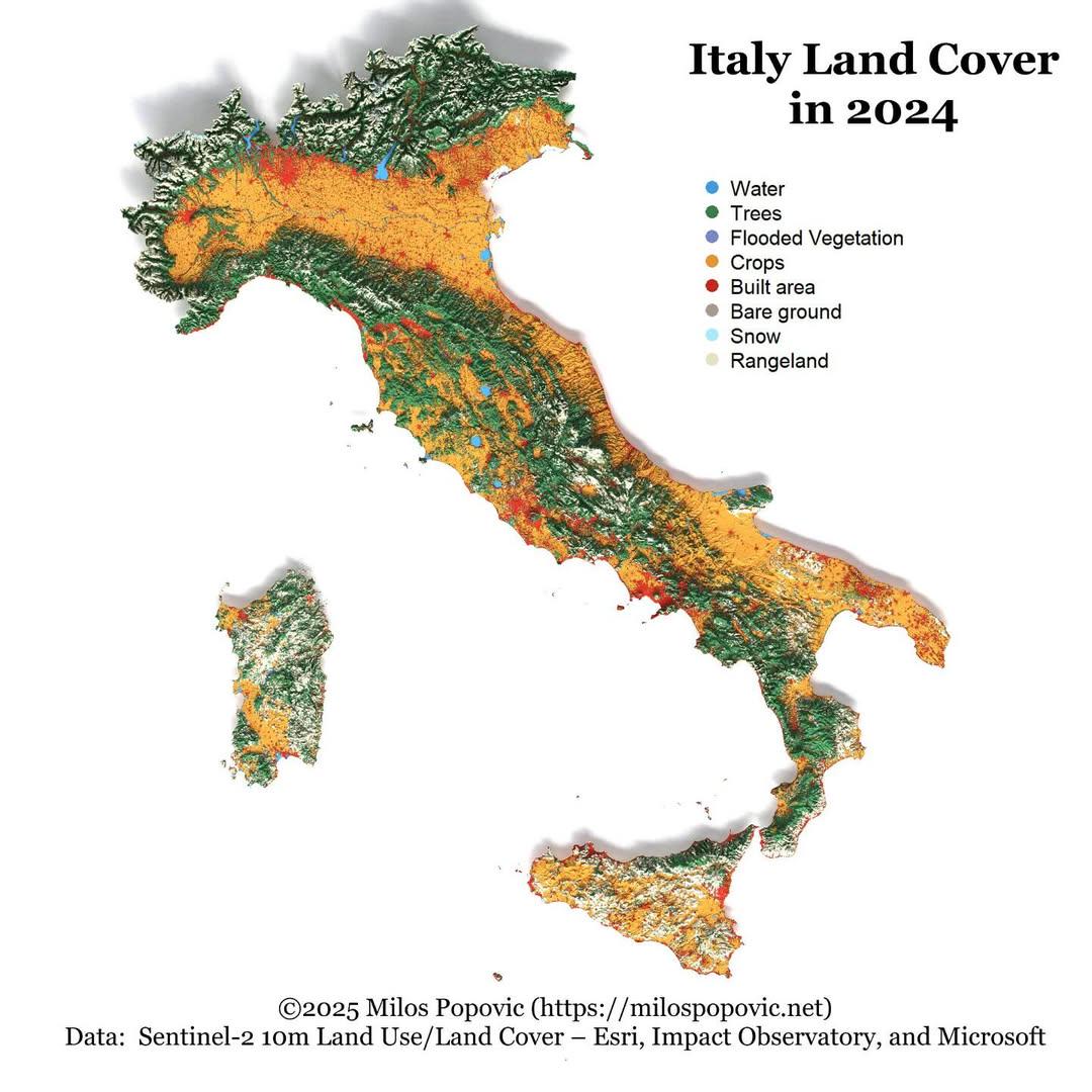
The "Italy Land Cover Map 2024" provides a comprehensive visualization of the various land cover types across Italy, illustrating the distribution of forests, agricultural lands, urban areas, and water bodies. This map serves as a crucial tool for understanding how land is utilized and managed in one of Europe’s most iconic countries. As we delve deeper into the topic of land cover, we can explore the significance of each land type and its implications for biodiversity, agriculture, and urban development.
Deep Dive into Land Cover in Italy
Land cover refers to the physical material at the surface of the Earth. In Italy, the diversity of land cover is remarkable, heavily influenced by the country's varied topography, climate, and human activity. Approximately 30% of Italy is covered by forests, making it one of the key features of the Italian landscape. Forests are predominantly found in the northern regions, particularly in the Apennines and the Alps, where species such as beech, fir, and larch thrive. Interestingly, these forests are not just vital for biodiversity; they also play a crucial role in carbon sequestration, helping to mitigate climate change effects.
Agricultural land constitutes another significant portion of Italy’s land cover, accounting for nearly 40% of the total area. The country is famous for its diverse agricultural products, from olives and grapes to cereals and vegetables. The Po Valley, for example, is the agricultural heartland of Italy, known for its fertile soil and extensive irrigation systems. This region is essential for the production of rice, an important crop that sustains both local and national economies. Have you noticed how Italian cuisine is deeply rooted in local agricultural practices?
Urban areas, while covering a smaller percentage of the land—around 7%—are crucial for understanding Italy's demographic and economic dynamics. Major cities like Rome, Milan, and Naples have seen significant urban sprawl, driven by population growth and economic opportunities. The challenges posed by rapid urbanization, such as air pollution and loss of green spaces, are critical considerations for future urban planning.
Water bodies, including rivers, lakes, and coastal areas, make up about 1% of Italy’s land cover. The Tiber River, for instance, is not only a vital water source but also holds historical significance for the development of Rome. The preservation of these water bodies is essential for maintaining biodiversity and supporting various ecosystems.
Regional Analysis
When analyzing land cover across different regions of Italy, notable contrasts emerge. In the northern regions, such as Lombardy and Trentino-Alto Adige, forest cover is significantly higher than in the southern regions like Calabria and Sicily, where agriculture dominates. The differences can be attributed to variations in climate, topography, and historical land use practices.
For example, the mountainous areas in the north are more suited for forestry, while the flatter and milder southern regions have been extensively cultivated for agriculture. Interestingly, urbanization is also more pronounced in the north, where cities like Milan and Turin serve as economic hubs, starkly contrasting with the slower urban growth seen in the southern regions.
The central region, particularly Tuscany, showcases a blend of agriculture and urban development, characterized by picturesque landscapes dotted with vineyards and olive groves. This diversity not only enriches the cultural identity of the regions but also presents varying challenges in land management and conservation efforts.
Significance and Impact
Understanding land cover in Italy is essential for several reasons. Firstly, it helps in assessing the environmental health of the country. For instance, the preservation of forests is vital for maintaining biodiversity and combating climate change. Moreover, with ongoing discussions about sustainable development, knowing how land is utilized can inform policy decisions that balance economic growth with environmental conservation.
Current trends indicate a gradual shift towards more sustainable agricultural practices, driven by consumer demand for organic and locally sourced products. Furthermore, as urban areas continue to grow, the challenge will be to integrate green spaces into city planning to enhance the quality of life for urban residents. As we look towards the future, projections suggest that managing land cover effectively will be crucial for Italy’s resilience against climate change and ecological degradation.
In conclusion, the "Italy Land Cover Map 2024" not only provides a snapshot of how land is used today but also serves as a guide for future planning and conservation efforts. By understanding the complexities of land cover, we can better appreciate the intricate relationship between human activity and the natural environment in this beautiful country.
Visualization Details
- Published
- October 19, 2025
- Views
- 30
Comments
Loading comments...