Ethnic Groups Map of Poland in 1914

David Chen
Data Visualization Specialist
David Chen is an expert in transforming complex geographic datasets into compelling visual narratives. He combines his background in computer science ...
Geographic Analysis
What This Map Shows
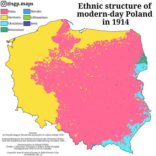
This map titled "Ethnic Poles, Germans & Other Groups Living Within The Borders Of Modern Poland In 1914" provides a striking visual representation of the complex tapestry of ethnic identities that existed in Poland on the eve of World War I. It showcases the distribution of various ethnic groups, highlighting not only the Polish majority but also the significant German minority and other communities. By examining the map, one can gain insights into the demographic landscape that shaped Poland’s historical narrative during a tumultuous period in European history.
Deep Dive into Ethnic Diversity in Poland
The early 20th century was a time of immense ethnic diversity in Poland, a fact that is vividly illustrated by this map. In 1914, the territory of modern Poland was divided among three empires: the German Empire, the Austro-Hungarian Empire, and the Russian Empire. Each of these empires influenced the demographics and cultural landscape of the regions they governed.
Interestingly, the Polish people, despite being the largest ethnic group, were not the only significant presence. The map indicates substantial populations of Germans, particularly in the western regions, and Jews, who constituted vital cultural and economic contributors in urban areas. In fact, before World War I, Poland was home to one of the largest Jewish populations in Europe, particularly concentrated in cities like Warsaw and Lodz.
The German presence in regions such as Silesia and Posen can be traced back to earlier migrations and policies of settlement encouraged by the Prussian state. This created a sense of tension and competition for resources, especially as nationalism grew within the Polish populace. The map illustrates these dynamics by showing the distinct areas where ethnic identities were concentrated, revealing a landscape ripe with cultural intersections and conflicts.
Furthermore, the presence of other ethnic groups, such as Ukrainians and Belarusians, adds layers to the understanding of Poland's demographic complexities. The map indicates that these groups were primarily located in the eastern parts of the country, where the influence of the Russian Empire was more pronounced. Their presence further complicates the historical narrative, as issues of identity, autonomy, and cultural preservation came to the forefront during this period of upheaval.
Regional Analysis
When analyzing the map regionally, we observe several key distinctions. In the western territories, particularly in Silesia, the German population was notably higher, reflecting the area's historical integration into the German Empire. This region was characterized by industrial development, which attracted many German settlers. Conversely, in Central and Eastern Poland, the Polish majority became more pronounced, particularly in regions like Masuria and Podlasie, where traditional Polish culture thrived.
Interestingly, the map also shows that the urban centers, such as Warsaw and Krakow, were melting pots of various ethnicities. Warsaw, for example, had a vibrant Jewish community that played an essential role in the city's economic life. By contrast, rural areas tended to be more homogeneous, with Polish peasants dominating the landscape. This rural-urban divide is crucial for understanding the social fabric of Poland at that time, as it set the stage for future political movements and conflicts.
Significance and Impact
Understanding the ethnic composition of Poland in 1914 is vital for grasping the historical context leading to the events of the 20th century. The tensions between different ethnic groups, fueled by nationalist sentiments and imperial policies, contributed to the fragmentation of the region during World War I and the subsequent establishment of an independent Poland in 1918.
Moreover, the legacy of this ethnic diversity continues to influence Poland today. The map serves as a reminder of the historical complexities that shape contemporary Polish society. With recent discussions around minority rights and cultural heritage, the significance of understanding these historical demographics cannot be overstated. The interplay of various ethnic identities within Poland has evolved but remains relevant, reflecting ongoing dialogues about national identity and unity in diversity.
As we look to the future, one can't help but wonder how this rich tapestry of ethnic backgrounds will continue to shape the narratives and policies of modern Poland. The historical context provided by this map serves as a critical lens through which we can view current societal trends and challenges in a country that has undergone significant transformations over the last century.
Visualization Details
- Published
- October 18, 2025
- Views
- 36
Comments
Loading comments...