China's Controversial Border Map

Alex Cartwright
Senior Cartographer & GIS Specialist
Alex Cartwright is a renowned cartographer and geographic information systems specialist with over 15 years of experience in spatial analysis and data...
Geographic Analysis
What This Map Shows
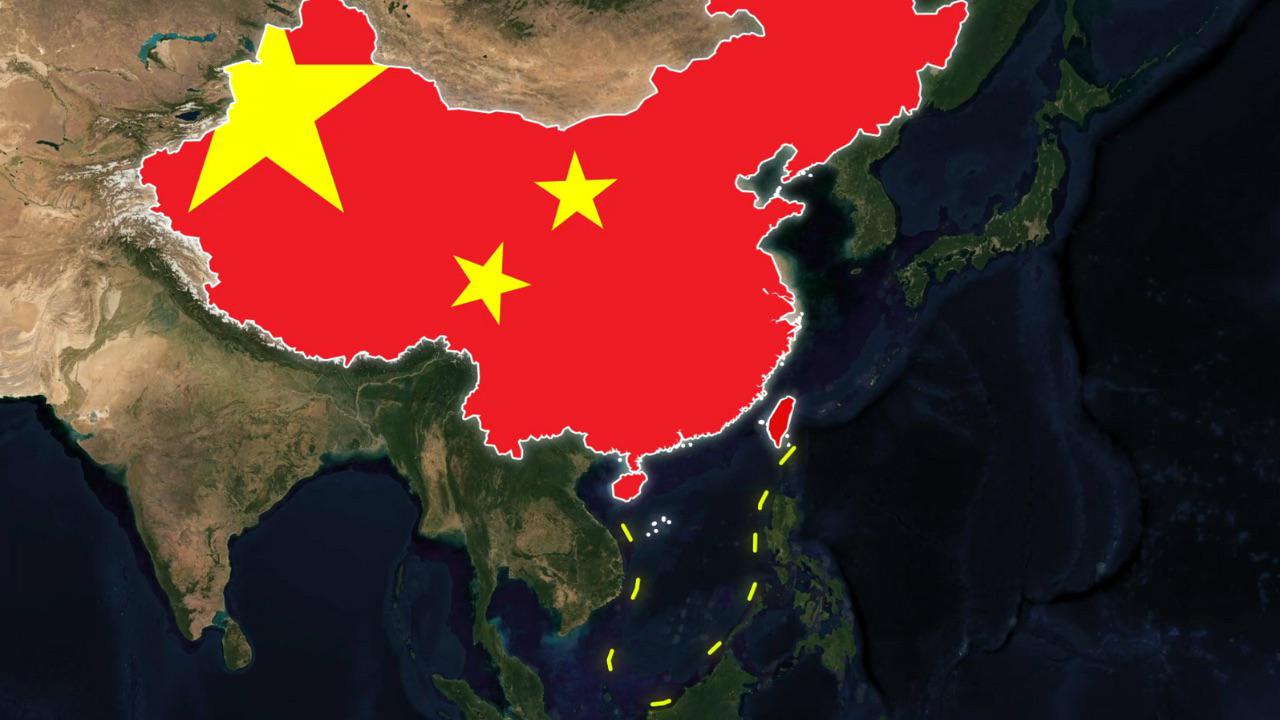
The map in question illustrates the shifting borders of China as viewed through various platforms like Apple Maps and Google Earth. This intriguing visualization highlights how territorial delineations can differ significantly depending on the source, leading to heated debates and even geopolitical tensions. The disparities aren’t just a matter of aesthetics; they reflect deep-seated national narratives, historical claims, and contemporary political realities.
Deep Dive into China's Territorial Claims
China's territorial claims are complex and often contentious. The country's borders have evolved throughout history, influenced by dynastic changes, colonial encounters, and modern political maneuvers. One of the most significant areas of dispute is the South China Sea, where China claims almost the entire area, marked by the infamous Nine-Dash Line. This line has become a symbol of China’s assertiveness in the region, leading to conflicts with neighboring countries such as Vietnam, the Philippines, and Malaysia, all of which have their own claims.
Interestingly, these territorial claims are not just about land and sea; they encompass cultural and historical significance as well. The regions within these claimed borders often have diverse populations, each with unique identities and histories. For instance, Tibet and Xinjiang are often cited in discussions about human rights and cultural autonomy, showcasing how borders are more than mere lines on a map.
Furthermore, China’s approach to territorial integrity is deeply rooted in its national identity. The idea of a unified China, or ‘Zhongguo,’ is a driving force behind its policies, both domestically and internationally. The government emphasizes the importance of territorial sovereignty, often using maps that include disputed regions as part of its national narrative. For example, the portrayal of Taiwan as part of China on maps is not just a political statement; it’s a reflection of how China views itself historically and culturally.
Regional Analysis
When examining the regional variations depicted in these maps, it’s essential to consider both the historical context and current geopolitical tensions. For instance, in the northeast, the border with Russia has been relatively stable since the Sino-Soviet border agreement in the 2000s. However, in the southwest, the borders with India and Nepal are marked by a history of conflict, highlighted by the Sino-Indian War of 1962. The maps often depict these areas with differing levels of clarity, reflecting the contentious nature of these borders.
The South China Sea region is perhaps the most dramatic example of how borders can shift in significance. The overlapping claims by multiple countries lead to a patchwork of maritime boundaries that are often portrayed differently, depending on the political leanings of the mapmaker. For instance, a map from a Chinese perspective might emphasize the Nine-Dash Line, while a map from a Southeast Asian country would highlight its exclusive economic zone, leading to stark contrasts in how these areas are visualized.
Significance and Impact
Understanding the implications of these shifting borders is crucial in today’s globalized world. The disputes often lead to military standoffs, diplomatic negotiations, and sometimes even armed conflict. The significance of the map extends beyond geography; it touches on issues of national identity, regional stability, and international relations. With rising tensions in the South China Sea, the stakes have never been higher.
Moreover, how borders are represented in digital maps can influence public perception and policy-making. For instance, when major platforms like Google and Apple adjust their maps to reflect geopolitical realities, it can lead to significant backlash from governments and populations. This highlights the power of cartography in shaping narratives and influencing international relations.
As we move forward, the importance of understanding these territorial disputes will only grow. With technology evolving and digital maps becoming more integrated into our daily lives, the way we visualize borders will continue to play a crucial role in shaping geopolitical dynamics. Have you ever noticed how a simple map can spark so much discussion about identity and belonging? It’s a powerful reminder of the role geography plays in our lives.
Visualization Details
- Published
- October 17, 2025
- Views
- 42
Comments
Loading comments...