First World War Casualties Mapped

Marcus Rodriguez
Historical Geography Expert
Marcus Rodriguez specializes in historical cartography and geographic data analysis. With a background in both history and geography, he brings unique...
Geographic Analysis
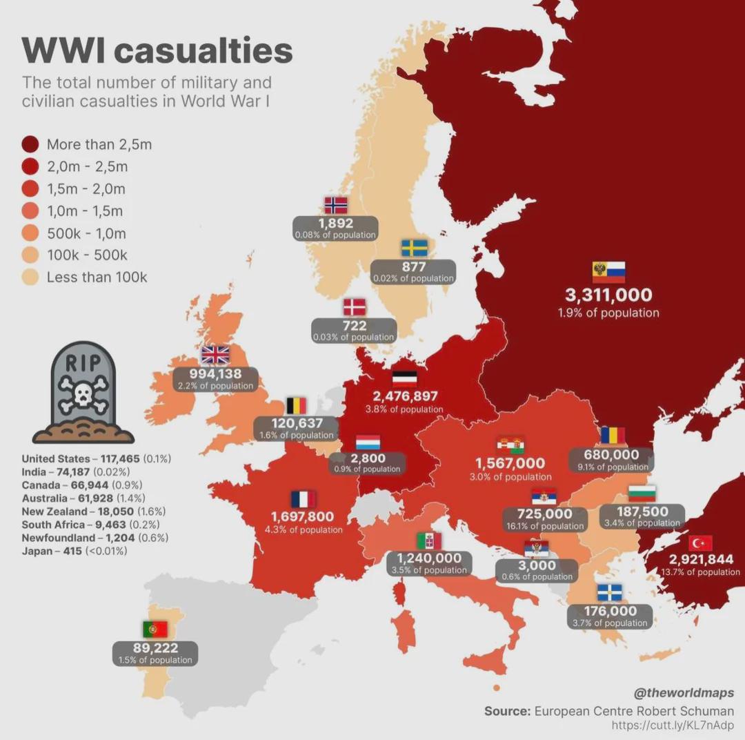
What This Map Shows
The "First World War Casualties Mapped" visualization provides a comprehensive overview of military and civilian casualties during one of history's most devastating conflicts. It displays data by country, showcasing the staggering human cost of the war, with figures highlighting both military personnel and civilian losses. The map serves as a stark reminder of the impact of World War I, illustrating not just the sheer numbers but also the geographical distribution of these casualties across Europe and beyond.
Deep Dive into First World War Casualties
World War I, which lasted from 1914 to 1918, was marked by unprecedented levels of destruction and loss of life. An estimated 16 million people died as a result of the conflict, with around 10 million military personnel and approximately 7 million civilians. This staggering statistic is a grim testament to the war's brutality.
The causes of these casualties were multifaceted. The war introduced new military technologies such as machine guns, artillery, and chemical weapons, which led to higher fatalities on the battlefield. Trench warfare, characterized by long stalemates and grueling conditions, further exacerbated the loss of life. Soldiers faced not only the enemy but also harsh weather, disease, and starvation, contributing to the casualty figures.
Interestingly, the casualties were not evenly distributed. Countries like Germany and Russia bore a particularly heavy burden. Germany reported around 2 million military deaths and a significant number of civilian casualties due to blockades and military actions. Meanwhile, Russia faced staggering losses, with estimates of military deaths reaching over 1.8 million, compounded by social and economic turmoil at home.
On the other hand, smaller nations, while experiencing fewer total casualties, often found their populations significantly affected. For example, Belgium, invaded in 1914, saw a high percentage of its population affected by military actions and subsequent occupation, leading to approximately 38% of its civilian population suffering due to the war.
The map also highlights the colonial dimensions of the war, where countries like Britain and France mobilized troops from their colonies. Soldiers from India, Africa, and the Caribbean fought on European battlefields, adding to the casualty numbers and showcasing the global reach of the conflict.
Regional Analysis
When examining the map regionally, the differences in casualty rates become apparent. Western European countries like France and Britain faced high military losses due to the intensity of battles such as the Somme and Verdun. France alone suffered around 1.4 million military deaths, while Britain lost approximately 900,000 soldiers. The geographical concentration of battles in these areas explains the high casualty rates.
In Eastern Europe, the situation was different. The Eastern Front was characterized by massive movements of troops and larger geographic distances, leading to chaotic retreats and high casualties. Russia's vast territory made it challenging to maintain supply lines, contributing to its extraordinary military losses. The map illustrates this geographical disparity, emphasizing how the location of battles influenced casualty rates.
In contrast, countries like the United States, which entered the war later in 1917, reported lower casualty figures relative to the size of their military involvement. The U.S. military lost about 116,000 personnel, a stark contrast to the millions lost by European powers. This disparity can be seen in the map, which highlights the timing and scale of military engagement.
Significance and Impact
Understanding the human cost of the First World War is crucial for grasping the war's lasting impacts on society, politics, and international relations. The casualties not only shaped the post-war landscape but also influenced the course of future conflicts. The Treaty of Versailles, which ended the war, imposed heavy reparations on Germany and redrew national boundaries, setting the stage for World War II.
Moreover, the war's social implications were profound. The loss of a generation of young men led to demographic shifts and social changes across Europe. Countries faced labor shortages, prompting women to enter the workforce in unprecedented numbers. The map serves as a powerful visual reminder of these transformations, illustrating how the war's legacy continues to resonate today.
In contemporary discussions, the casualties of World War I remind us of the importance of peace and diplomacy. As we reflect on the past, it becomes clear that understanding the scale of human loss is essential to prevent future conflicts. The map not only provides data but also tells a story of resilience, tragedy, and the enduring impact of war on humanity.
Visualization Details
- Published
- October 10, 2025
- Views
- 60
Comments
Loading comments...