Territorial Extent Map of the Kingdom of Brittany (9th-10th Century AD)

Alex Cartwright
Senior Cartographer & GIS Specialist
Alex Cartwright is a renowned cartographer and geographic information systems specialist with over 15 years of experience in spatial analysis and data...
Geographic Analysis
What This Map Shows
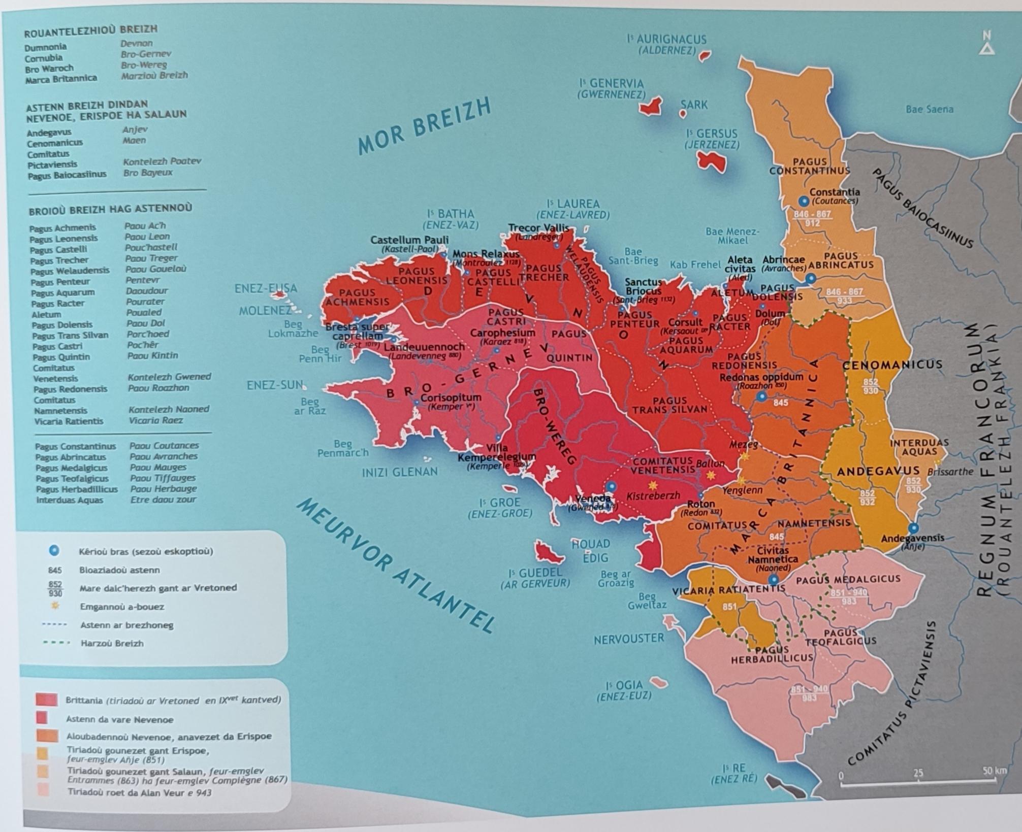
The map titled "Territorial Extent of the Kingdom of Brittany (9th-10th Century AD)" provides a detailed portrayal of the geographical boundaries and regions governed by the medieval kingdom of Brittany during a pivotal time in its history. It visually represents the expanse of this Celtic kingdom, illustrating not only the territory it occupied but also the significant cultural and political landscapes of the era. As we delve deeper, we’ll explore the historical context of Brittany's territory and its importance in shaping the region's identity.
Deep Dive into the Kingdom of Brittany
The Kingdom of Brittany, established around the 5th century, emerged as a distinct entity during the early Middle Ages. By the 9th and 10th centuries, Brittany had developed into a powerful kingdom characterized by its unique Celtic heritage, language, and customs. The territory shown on the map encompasses present-day Brittany in northwestern France, extending beyond modern borders into parts of what is now Normandy and potentially influencing regions up to the Loire River.
Interestingly, the map highlights not just land but also the intricate web of alliances and rivalries that defined Brittany's political landscape. During this period, Brittany was notable for its resistance against external influences, particularly from the Franks and later the Normans. This resistance was fueled by a strong sense of identity and autonomy among its inhabitants, who were primarily of Celtic descent.
The kingdom's geography played a crucial role in its development. The rugged coastline provided natural defenses against invasions, while fertile lands supported agriculture and livestock. The rivers, such as the Vilaine and the Rance, were vital for trade and transportation, facilitating economic prosperity and cultural exchange with neighboring regions. Have you ever wondered how geography influences political boundaries? In Brittany's case, its natural features greatly contributed to its territorial delineation and governance.
Regional Analysis
Examining the map reveals several key regions within the Kingdom of Brittany. The core area, known as the "Duchy of Brittany," was concentrated around the modern cities of Rennes, Nantes, and Vannes. Each of these areas had its own significance. For instance, Rennes, as the political capital, was the center of administrative activities, while Nantes, with its strategic location on the Loire, served as a crucial port for trade.
Interestingly, the influence of the sea cannot be understated. The coastal regions were not only vital for fishing but also for establishing trade routes that connected Brittany with other parts of Europe, including the British Isles. This maritime prowess allowed Brittany to thrive economically and culturally, setting it apart from other territories during the same period.
In contrast, the more inland regions, while less populated, held strategic importance due to their agricultural output. The fertile plains supported crops like wheat and barley, which were fundamental to the kingdom's sustenance and economy. The map's delineation of these regions highlights the diverse economic activities that contributed to the kingdom's resilience.
Significance and Impact
Understanding the territorial extent of the Kingdom of Brittany during the 9th and 10th centuries is vital for appreciating the historical complexities of not just Brittany, but also of France as a whole. Brittany's unique status as a Celtic kingdom persisted well into the medieval period, influencing its cultural and political relationships with neighboring territories.
Today, Brittany's legacy continues to resonate, particularly in its cultural practices, language revival efforts, and regional autonomy movements. The map serves as a reminder of how historical boundaries shape modern identities and regional dynamics. As we look towards the future, the ongoing interest in Brittany's heritage and its historical significance reflects a broader trend of regional pride and cultural revival in many parts of Europe.
In conclusion, the territorial extent of the Kingdom of Brittany is more than just a historical curiosity; it represents a crucial chapter in the narrative of European history, characterized by a unique blend of cultural resilience and political autonomy. What will the future hold for Brittany as it continues to navigate its rich past while forging a path forward in the modern world?
Visualization Details
- Published
- October 1, 2025
- Views
- 50
Comments
Loading comments...