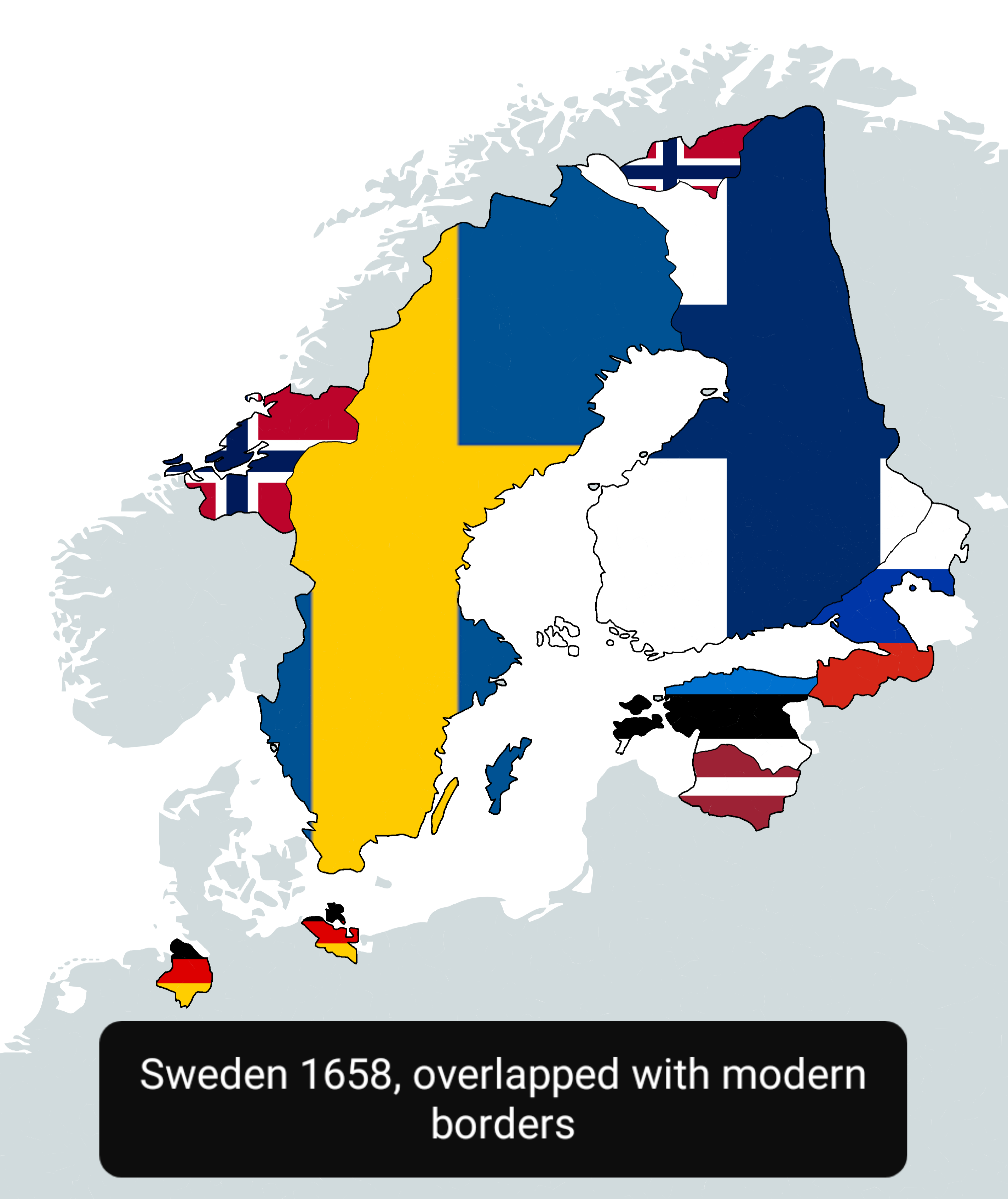
Sweden in 1658 Map Overlapped with Modern Countries

Alex Cartwright
Senior Cartographer & GIS Specialist
Alex Cartwright is a renowned cartographer and geographic information systems specialist with over 15 years of experience in spatial analysis and data...
Geographic Analysis
What This Map Shows
This map visually represents Sweden as it was in 1658, overlapped with the boundaries of modern countries. It allows us to see how the geopolitical landscape of Northern Europe has changed over the centuries. Notably, it highlights territories that were once part of Sweden, including parts of present-day Finland, Norway, Denmark, and the Baltic states. By examining this map, we can gain insights into the historical territorial expansions and contractions of Sweden and their lasting impacts on contemporary nation-states.
Deep Dive into Sweden's Historical Territory
Sweden's history as a powerful kingdom during the 17th century was characterized by military conquests and territorial acquisitions, particularly during the era known as the Swedish Empire. At its height, the empire encompassed not just modern Sweden but also significant portions of Finland, the Baltic states, and parts of what are now Russia and Poland. The year 1658 marks a crucial point in this history when Sweden acquired territories following the Treaty of Roskilde.
During this period, Sweden was a major player in European politics, heavily involved in conflicts such as the Thirty Years' War. The map shows how Sweden's borders extended far beyond its current limits, encompassing regions with diverse populations and cultures. For instance, the inclusion of parts of Finland reveals the historical ties between these two nations, which were politically united until Finland gained its independence in 1917.
Interestingly, the map also indicates the areas of present-day Denmark that were once Swedish territories. The conflict over these lands was part of the broader struggle for dominance in the Baltic Sea, which was a vital trade route at the time. This rivalry has shaped not only the borders but also the cultural identities of the Scandinavian countries.
The demographic landscape was significantly different then as well. The Swedish Empire was characterized by a mix of ethnic groups, including Finns, Sami, Estonians, and Latvians. This diversity has had long-lasting implications for the region, influencing everything from language to cultural practices. The interactions between these groups during the Swedish rule laid the groundwork for the complex social fabric of modern Scandinavia.
Regional Analysis
When examining the map more closely, we can delineate specific regions that were once governed by Sweden. For example, the area of present-day Finland was largely Swedish territory until the 19th century. Today, Finland is an independent nation, but the historical influence of Sweden remains evident in its language and culture.
In contrast, the territories that are now part of Estonia and Latvia show a different historical trajectory. While these areas were once under Swedish control, they have experienced various rulers through the centuries, including Russian and German influences, which have shaped their modern identities. The complexities of these historical relationships can be seen in the languages spoken and the cultural festivals celebrated in these countries today.
Moreover, the map also brings into focus areas of Norway that were once Swedish territories. Interestingly, the union between Norway and Sweden lasted from 1814 until 1905, highlighting how the historical ties between these nations were not merely territorial but also political and cultural. The shared history has fostered strong connections that persist in various forms, such as cooperative agreements and cultural exchanges.
Significance and Impact
Understanding Sweden's historical territories is crucial for comprehending the modern geopolitical landscape of Northern Europe. The historical expansion and subsequent contractions of Sweden's borders have left a profound impact on current international relations, trade, and cultural exchange in the region. The historical grievances and alliances formed during this era continue to influence diplomatic relations between these countries.
Moreover, as we face increasing globalization, the implications of historical borders become even more relevant. Countries are now navigating the complexities of shared history while striving for regional cooperation in areas such as environmental protection and economic trade. Future projections suggest that as tensions arise over resources and territorial claims, particularly in the Baltic Sea region, understanding historical contexts will be vital for fostering peaceful relations.
In conclusion, the map of Sweden in 1658, overlapped with modern countries, is not just a historical artifact; it serves as a reminder of the intricate web of relationships that have shaped Northern Europe. By engaging with this map, we can better appreciate the historical narratives that continue to influence contemporary society and politics. Have you ever wondered how these historical shifts affect our lives today? The answer lies in the rich tapestry of our shared past, as illustrated by this fascinating map.
Visualization Details
- Published
- October 1, 2025
- Views
- 52
Comments
Loading comments...