Population Density Map of the West Bank

Marcus Rodriguez
Historical Geography Expert
Marcus Rodriguez specializes in historical cartography and geographic data analysis. With a background in both history and geography, he brings unique...
Geographic Analysis
What This Map Shows
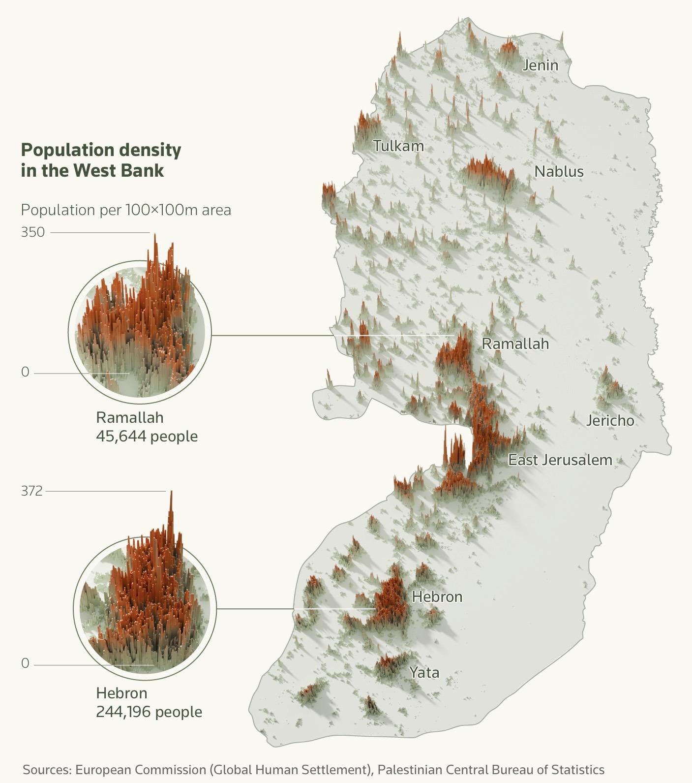
The "Population Density Map of the West Bank" provides a detailed visualization of the distribution of people across this contested and historically rich region. By showcasing the population per square kilometer, the map allows us to discern patterns of settlement, urbanization, and demographic concentration that are pivotal to understanding the socio-political landscape of the West Bank.
The West Bank, located in the heart of the Middle East, is home to a complex tapestry of cultures and communities. The population density map highlights not only where people live but also the factors influencing these patterns, such as geography, political boundaries, and economic opportunities.
Deep Dive into Population Density in the West Bank
Population density is a crucial indicator that reflects how people are distributed across a specific area. In the West Bank, this density is particularly significant due to the historical and contemporary challenges faced by its inhabitants. As of the latest estimates, the population of the West Bank stands at approximately 2.8 million people, with a density that varies greatly from one area to another.
Urban centers like Ramallah and Bethlehem showcase some of the highest population densities. Ramallah, which serves as the administrative capital for the Palestinian Authority, has seen rapid urban development. Its population density is markedly high, reflecting both an influx of residents from surrounding rural areas and an increase in job opportunities that attract people from various backgrounds. Interestingly, the map reveals that while urban areas are densely populated, many rural regions have much lower densities, often due to economic factors and the geographical constraints imposed by the Israeli settlements and military zones.
In contrast, areas such as Area C, which is under full Israeli control, present a different story. The population density here is lower, partly due to restrictions on Palestinian development and movement. It raises questions about accessibility and the ability of communities to grow. Ever wondered why some towns seem to flourish while others struggle? The answer often lies in local governance, economic opportunities, and infrastructure.
Additionally, demographic trends in the West Bank are influenced by various factors including birth rates, migration patterns, and political circumstances. The Palestinian population has a relatively high birth rate compared to global averages, which contributes to a youthful demographic profile. This youthful population can pose both opportunities and challenges: on one hand, it could lead to a vibrant workforce; on the other, it can strain resources and public services.
Regional Analysis
When we break down the map by region, intriguing contrasts emerge. For instance, the northern area of the West Bank, including cities like Nablus and Jenin, exhibits higher population densities due to their historical significance and economic activity. These cities are known for their commerce and education, attracting residents from surrounding areas.
Conversely, the southern districts, including Hebron, show a more complex picture. While Hebron itself has a significant population density, the surrounding areas are often less populated due to socio-political issues and restrictions on movement. The settlements that dot the landscape can further complicate population distribution, as they create enclaves that alter access to resources and services.
Interestingly, the map also brings attention to the differences between the Palestinian and Israeli populations within the West Bank. Israeli settlements, while numerically fewer, often have higher density due to their developed infrastructure and amenities. This juxtaposition raises critical discussions about land use, settlement policies, and their impact on Palestinian communities.
Significance and Impact
Understanding population density in the West Bank is not just an academic exercise; it has real-world implications for policy-making, resource allocation, and future development plans. The patterns depicted in the map highlight the urgent need for infrastructure improvements in densely populated urban centers, where services such as housing, education, and healthcare are often strained.
Moreover, the demographic shifts and urbanization trends indicate that the Palestinian population is likely to continue growing, which will necessitate thoughtful planning and international cooperation. Have you noticed how urban areas in conflict zones often experience a unique blend of resilience and challenges? The West Bank is no exception, with its communities striving to adapt and thrive amidst ongoing political and economic hurdles.
As the region navigates its complex realities, the population density map serves as a critical tool for understanding not only where people live but also why they live there and what the future might hold. Current trends point towards increasing urbanization and a need for sustainable development strategies that can address the growing population's needs while respecting the region's intricate socio-political fabric.
In conclusion, this map isn't just about numbers; it's a lens through which we can view the dynamics of life in the West Bank, shedding light on the ongoing changes that shape the lives of millions in this contested region.
Visualization Details
- Published
- September 26, 2025
- Views
- 46
Comments
Loading comments...