Anglo-Saxon Migration and Settlement Map

Alex Cartwright
Senior Cartographer & GIS Specialist
Alex Cartwright is a renowned cartographer and geographic information systems specialist with over 15 years of experience in spatial analysis and data...
Geographic Analysis
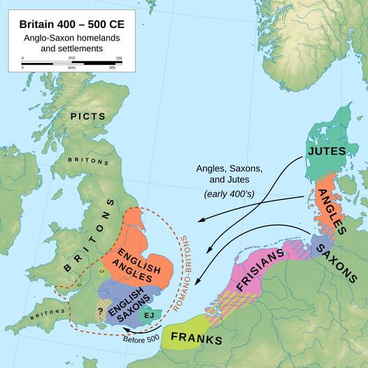
What This Map Shows\nThis map provides a detailed visualization of the Anglo-Saxon migration patterns and early settlements across England. It highlights the major tribes, centers of settlement, and the geographic areas they inhabited during their initial conquests from the 5th to the 7th centuries AD. The map serves as a crucial tool for understanding the early sociopolitical landscape of what would become England, illustrating how these migrations shaped the cultural and linguistic foundations of the region.
Deep Dive into Anglo-Saxon Migration and Settlement\nThe Anglo-Saxon migration was a significant event in British history, marking the transition from Roman Britain to the medieval period. Following the decline of Roman authority around 410 AD, various Germanic tribes, primarily the Angles, Saxons, and Jutes, began to migrate to Britain. This migration occurred over several decades and had profound implications for the region’s demographics, culture, and language.
Interestingly, the Anglo-Saxons did not migrate as a single wave; instead, they arrived in several groups and settled in various regions. The Angles predominantly settled in the East Midlands, Northumbria, and East Anglia, while the Saxons established themselves in the South and West, particularly in Sussex and Wessex. The Jutes primarily settled in Kent. What’s fascinating is how these migrations were often spurred by a combination of factors, including overpopulation, agricultural pressures, and the lure of fertile land in Britain.
Each group brought their own customs, language, and governance structures, leading to the establishment of several kingdoms, such as Mercia, Wessex, and Northumbria. The Anglo-Saxon period is characterized by the emergence of these kingdoms, which later formed the basis for the unified Kingdom of England. The map illustrates the geographical settings of these early kingdoms, showcasing their proximity to vital resources such as rivers, arable land, and coastlines, which were essential for trade and sustenance.
The impact of Anglo-Saxon settlement is still evident today, especially in the English language. Many of the words and grammatical structures we use have their roots in Old English, the language spoken by the Anglo-Saxons. Furthermore, the cultural practices and legal systems established during this era laid the groundwork for future governance and societal norms.
Regional Analysis\nExamining the map, we can see distinct regional variations in Anglo-Saxon settlement patterns. In the southeast, Kent became a significant area of Jutish influence, where early Christianization began, notably with the missionary efforts of Augustine in the late 6th century. On the other hand, regions like Mercia, situated in the heart of England, became a melting pot of various Anglo-Saxon tribes, leading to a diverse cultural and political landscape.
In the north, Northumbria emerged as a powerful kingdom, notable for its contributions to art and learning, particularly during the reign of King Oswald in the 7th century. The map shows the spread of settlements along the River Tyne and the River Wear, which were crucial for trade and transport.
Interestingly, the map also indicates areas of conflict, such as the border regions between Wessex and Mercia, where territorial disputes often arose, leading to shifting alliances and power dynamics. The archaeological evidence, including burial mounds and remnants of early churches, supports these historical narratives, providing insight into the lives of the Anglo-Saxons and their interactions with one another.
Significance and Impact\nUnderstanding Anglo-Saxon migration and settlement is not just about looking back at history; it holds significant implications for our understanding of modern England. The legacy of the Anglo-Saxons can be seen in the English language, legal systems, and even place names that persist today. Ever wondered why so many towns in England have names derived from Old English? This is a direct result of the Anglo-Saxon influence.
Moreover, the map serves as a reminder of how migration patterns can reshape cultural identities and societal structures. As we witness ongoing migrations in today’s world, the lessons from Anglo-Saxon history highlight the complexities and potential of cultural integration. The future of England, much like its past, will be shaped by the interactions and influences of diverse groups.
In conclusion, the Anglo-Saxon migration and settlement map is more than just a historical tool; it’s a lens through which we can examine the roots of modern England and the enduring impact of migration on cultural landscapes. The story of the Anglo-Saxons is one of resilience, adaptation, and transformation, lessons that continue to resonate in our contemporary world.
Visualization Details
- Published
- September 26, 2025
- Views
- 80
Comments
Loading comments...