WWII Nazi Propaganda Map of Empires

Marcus Rodriguez
Historical Geography Expert
Marcus Rodriguez specializes in historical cartography and geographic data analysis. With a background in both history and geography, he brings unique...
Geographic Analysis
What This Map Shows
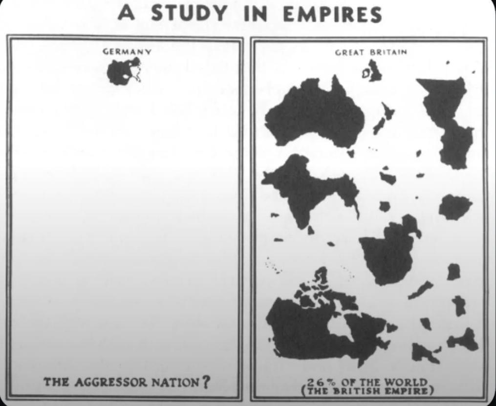
The visualization titled "WWII Nazi Propaganda Map Comparing British and German Empires" serves as a striking representation of the geopolitical landscape during World War II. It highlights the territories controlled by both the British Empire and Nazi Germany, showcasing not just the extent of their influence but also the underlying propaganda motives during the war. What’s particularly notable about this map is how it employs visual manipulation to convey a narrative that supported Nazi ideologies, portraying the German Empire as a burgeoning force against the imperialist ambitions of Britain.
Deep Dive into Imperialism and Propaganda
The concept of empire, particularly during the late 19th and early 20th centuries, was deeply intertwined with notions of power, control, and cultural superiority. The British Empire, at its zenith, was often described as "the empire on which the sun never sets," encompassing vast territories across continents, including parts of Africa, Asia, and the Americas. In contrast, Nazi Germany, through its aggressive military campaigns and expansionist policies, sought to create a new empire based on Aryan supremacy and territorial conquest.
Interestingly, empires are not merely defined by their size but by the ideologies they propagate. The British Empire often justified its colonial rule with a paternalistic narrative, claiming to civilize native populations, while the Nazi regime presented its expansionism as a necessary step for the survival of the Aryan race. This map starkly contrasts these two imperial narratives, demonstrating how propaganda was employed to shape perceptions and rally support for their respective causes.
The use of propaganda in this context was not just about military might; it was also about cultural domination. The Nazis utilized maps as tools of persuasion, manipulating geographic data to depict their territorial ambitions favorably. By exaggerating the threat posed by British imperialism, they sought to unify the German populace against a common enemy, framing their military campaigns as defensive acts rather than aggressive invasions.
Moreover, the map’s design elements, such as color schemes and symbols, play a significant role in this propaganda. Darker shades often represent areas of control, while lighter hues might indicate contested territories. This strategic use of color not only provides immediate visual impact but also reinforces the narrative that Germany was expanding its influence at the expense of Britain.
Regional Analysis
Breaking the map down regionally reveals fascinating contrasts. For instance, in Africa, the British Empire had established a significant presence, with colonies such as Egypt, South Africa, and Nigeria. These regions were not just economically vital; they were also strategically important for controlling trade routes and resources. In contrast, Nazi Germany's ambitions in Africa were relatively limited. Their focus was primarily on Eastern Europe, where they aimed to establish Lebensraum (living space) for the German people.
In Asia, British colonial rule spanned vast areas, including India, which was often referred to as the "crown jewel" of the empire due to its immense resources and strategic importance. The Nazis, however, sought to undermine British control, believing that by destabilizing British rule in India, they could foster anti-colonial sentiments and gain support from local populations.
What’s also intriguing is the comparison of the Caribbean, where British colonies such as Jamaica and Barbados flourished. Here, the narrative of the map shifts, reflecting the complex interplay of colonialism, race, and economic exploitation. Interestingly, while both empires sought to exploit these regions for their resources, the propaganda used to justify their actions differed markedly, reflecting their unique ideologies and cultural narratives.
Significance and Impact
Understanding the nuances of this WWII Nazi propaganda map is essential for grasping the broader implications of imperialism and propaganda in shaping historical narratives. This topic matters because it highlights how geographical representations can be weaponized to influence public perception, rally support for military endeavors, and justify ideological positions.
In contemporary discussions, the legacy of these empires continues to influence global politics, cultural relations, and economic structures. The lessons learned from the manipulation of maps during WWII remind us to critically assess how geographical data is presented today. As we navigate issues of nationalism, colonial legacies, and global interdependence, the historical context provided by such maps can offer valuable insights into current trends and future projections. Have you noticed how the echoes of past empires still resonate in today’s geopolitical landscape? It’s a reminder that geography is not just about physical space; it’s deeply tied to the narratives we construct around power and identity.
Visualization Details
- Published
- September 25, 2025
- Views
- 38
Comments
Loading comments...