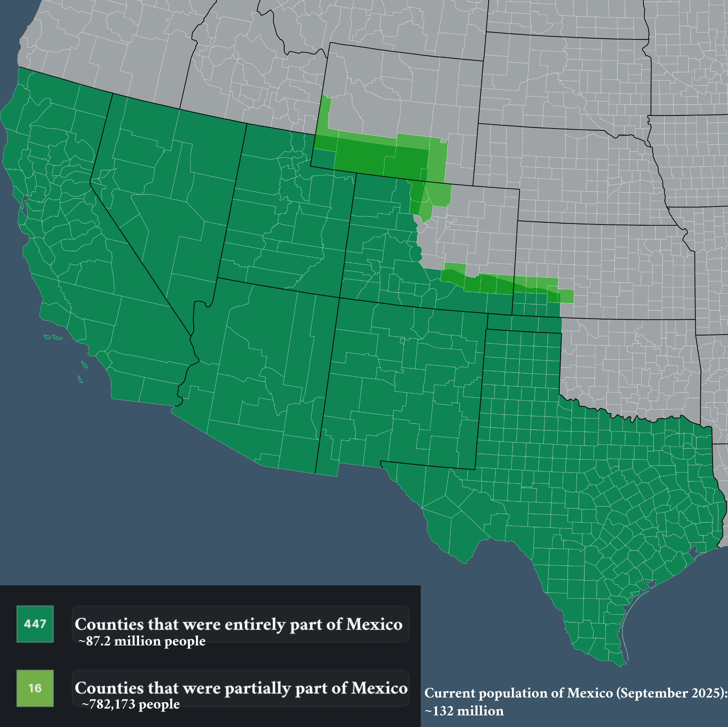
Map of Counties that Used to be Part of Mexico

Marcus Rodriguez
Historical Geography Expert
Marcus Rodriguez specializes in historical cartography and geographic data analysis. With a background in both history and geography, he brings unique...
Geographic Analysis
What This Map Shows
The visualization titled "Counties that used to be part of Mexico" provides an insightful look into the historical territories once governed by Mexico, particularly focusing on areas that are now part of the United States. This map highlights the counties that were included in the vast expanse of Mexican territory prior to the mid-19th century, particularly after the Mexican-American War and the subsequent Treaty of Guadalupe Hidalgo in 1848. By examining this map, one can appreciate the historical context of territorial changes and their lasting impacts on the demographic and cultural landscape of the United States today.
Deep Dive into the Historical Context
Have you ever wondered how the borders of the United States came to be and the role that Mexico played in shaping them? The story begins in the early 1800s when Mexico won its independence from Spain. At that time, the territory of Mexico extended far north, encompassing parts of present-day California, Nevada, Utah, Arizona, Texas, New Mexico, and even sections of Colorado, Wyoming, Kansas, and Oklahoma.
Interestingly, the relationship between the United States and Mexico was complex. Tensions grew as American settlers moved into Mexican territories, particularly in Texas, leading to a push for independence from Mexico in 1836. This ultimately led to Texas becoming a republic, and its annexation by the U.S. in 1845 aggravated existing conflicts.
The Mexican-American War (1846-1848) was a pivotal moment in this territorial saga. Following the war, the Treaty of Guadalupe Hidalgo was signed, resulting in Mexico ceding approximately half of its territory to the United States. This included not just Texas but also present-day California, Nevada, Utah, and parts of Colorado, Arizona, New Mexico, and Wyoming. This dramatic shift in borders not only altered the geography of North America but also sowed the seeds for cultural amalgamation that persists today.
As we delve deeper into the demographics of these counties, it’s intriguing to observe how the Mexican heritage is still prevalent in many areas. For instance, counties in Southern California, such as Los Angeles and San Diego, showcase a rich tapestry of Mexican culture through food, festivals, and language. Meanwhile, areas in Texas, like El Paso and San Antonio, are vibrant examples of how Mexican influence has shaped local identity.
Regional Analysis
Looking at the map, we can categorize the former Mexican territories into distinct regions, each with its unique history and cultural impact. In Texas, the landscape is marked by a strong Mexican-American community, reflective of its historical ties. Cities like Laredo and Brownsville not only serve as gateways to Mexico but also exemplify binational cultural exchanges.
In the southwestern United States, California stands out due to its significant Mexican heritage. Areas such as the San Francisco Bay and Los Angeles are known for their diverse Mexican communities, which continue to thrive and contribute to the state's dynamic culture. Interestingly, despite being integrated into the U.S. for over a century, the influence of Mexican traditions remains strong, evident in the popularity of events such as Cinco de Mayo and Día de los Muertos.
Meanwhile, in the more northern regions like parts of Colorado and New Mexico, the legacy of Spanish colonization, which predates Mexican governance, is still apparent in place names and cultural practices. These areas have a unique blend of Native American, Spanish, and Mexican influences, creating a rich cultural mosaic.
Significance and Impact
Understanding the historical context of these counties that were once part of Mexico is not merely an academic exercise; it has real-world implications. The demographic shifts that occurred following the territorial changes have resulted in a unique cultural landscape in the U.S. today. The presence of a significant Mexican-American population has influenced everything from politics to cuisine, and even art and music.
Currently, trends show that Mexican-Americans are one of the largest ethnic groups in the United States, contributing to the economy, culture, and society at large. As we move forward, recognizing this heritage can foster a greater appreciation for the multicultural fabric of the nation. Moreover, with ongoing discussions about immigration and border policies, understanding the historical context of U.S.-Mexico relations is crucial for informed dialogue.
In conclusion, the map of counties that used to be part of Mexico serves as a powerful reminder of the historical transformations that have shaped the United States. By acknowledging these roots, we can better appreciate the diverse cultures and communities that thrive in these regions today.
Visualization Details
- Published
- September 22, 2025
- Views
- 38
Comments
Loading comments...