World Population Density Map

David Chen
Data Visualization Specialist
David Chen is an expert in transforming complex geographic datasets into compelling visual narratives. He combines his background in computer science ...
Geographic Analysis
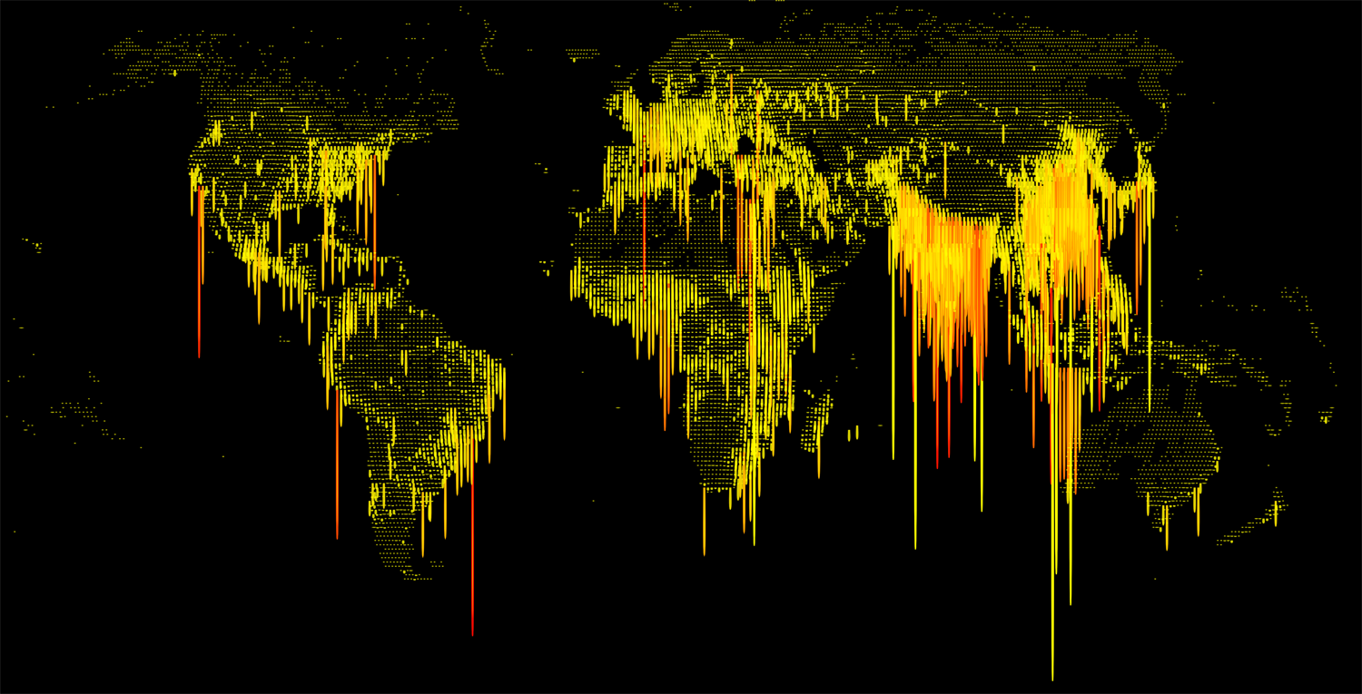
What This Map Shows
This visualization displays the population density of various regions across the globe, illustrating how many people inhabit each square kilometer. Population density is a crucial metric for understanding human settlement patterns, resource allocation, and urban planning. It’s essential to dive deeper into why some areas are densely populated while others remain sparsely inhabited.
Deep Dive into Population Density
Population density is not just a number; it reflects numerous factors, including geography, climate, economy, and social structures. Areas with high population densities often share certain characteristics. For instance, coastal regions and urban centers tend to attract larger populations due to better job opportunities, access to resources, and infrastructure. In contrast, regions with harsh climates, such as deserts or mountainous areas, often see lower densities due to the challenges they present for habitation.
According to the United Nations, the global population reached approximately 8 billion in 2022, with around 4.2 billion people living in urban areas. This urbanization trend highlights a significant shift in where people choose to live, often leading to congested cities. Interestingly, cities like Tokyo, Mumbai, and New York are known for their extreme population densities, where millions reside in relatively small areas.
Furthermore, population density can impact local economies and environmental sustainability. Higher densities can lead to more efficient public transport and lower per capita energy consumption, but they can also result in overcrowding, pollution, and increased demand for housing and services. For example, Singapore has managed to maintain a high population density while implementing innovative urban planning strategies that promote sustainability.
Regional Analysis
When we look at the world map, distinct patterns emerge in population distribution. - **Asia** is the most densely populated continent, with countries like Bangladesh and India topping the charts. Dhaka, the capital of Bangladesh, is one of the most densely populated cities globally, with over 44,000 people per square kilometer. - **Africa** shows significant contrasts, with regions like Nigeria experiencing rapid urbanization, particularly in cities like Lagos. On the other hand, vast areas of the Sahara remain almost uninhabited due to harsh conditions. - **Europe** has several densely populated areas, particularly in Western Europe, with cities like Paris and London. However, Eastern Europe has lower densities, especially in rural areas, as younger populations migrate to urban centers for better opportunities. - In **North America**, urban areas like New York City and Los Angeles feature high densities, while vast regions of Canada remain sparsely populated. - **South America** has notable urbanization in cities like São Paulo and Buenos Aires, leading to densely populated metropolitan areas, but also vast spaces of low density in the Amazon rainforest.
Significance and Impact
Understanding population density is vital for multiple reasons. It influences infrastructure development, public health, urban planning, and resource management. As the global population continues to rise, especially in developing nations, the challenges associated with high density, such as housing shortages, transportation issues, and environmental degradation, become increasingly pressing.
Have you noticed how cities are adapting to these challenges? Many are now prioritizing sustainable practices, investing in green spaces, and enhancing public transportation systems to improve quality of life. Projections indicate that by 2050, approximately 68% of the world’s population will reside in urban areas, intensifying the need for effective policies and planning.
In conclusion, the World Population Density Map not only highlights where people live but also serves as a window into the socio-economic dynamics shaping our world. Understanding these patterns is crucial for addressing the challenges of today and preparing for the future.
Visualization Details
- Published
- September 19, 2025
- Views
- 44
Comments
Loading comments...