Great Wall of South America Map

Marcus Rodriguez
Historical Geography Expert
Marcus Rodriguez specializes in historical cartography and geographic data analysis. With a background in both history and geography, he brings unique...
Geographic Analysis
What This Map Shows
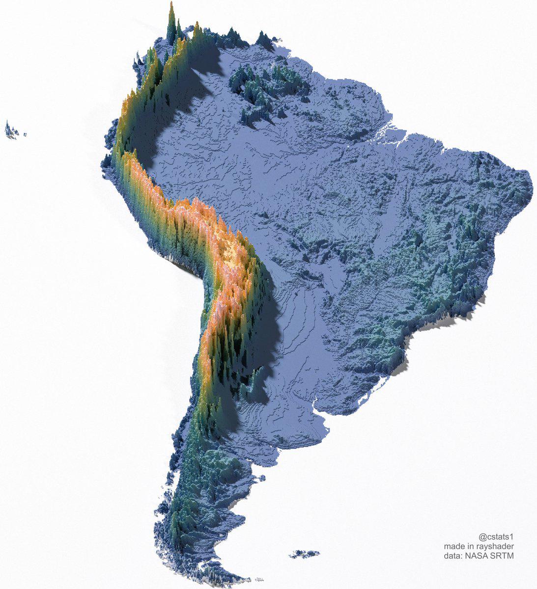
The "Great Wall of South America" map visualizes a unique geographical phenomenon, showcasing the extensive network of natural barriers formed by the Andes Mountains. Stretching over 4,300 miles along the western edge of South America, the Andes serve as a formidable natural wall, impacting everything from climate to biodiversity across the continent. This visualization highlights not only the impressive expanse of the mountain range but also its profound influence on the surrounding regions.
Deep Dive into the Andes Mountains
The Andes Mountains are the longest continental mountain range in the world, running through seven countries: Venezuela, Colombia, Ecuador, Peru, Bolivia, Chile, and Argentina. Formed by tectonic activity, the Andes are a result of the subduction of the Nazca Plate beneath the South American Plate. This geological process has created diverse landscapes, from towering peaks to deep valleys, and has established distinct climatic zones.
Interestingly, the Andes are not just known for their height; they also host a rich variety of ecosystems ranging from tropical rainforests in the north to arid deserts in the south. The eastern slopes of the Andes capture moisture from the Atlantic winds, resulting in lush vegetation, while the western side tends to be drier, leading to the formation of unique habitats. For instance, the Amazon rainforest, which lies to the east, is one of the most biodiverse places on Earth, while the Atacama Desert in Chile, located to the north, is one of the driest.
What's fascinating is how the Andes have shaped human civilization. The Inca Empire, one of the most advanced ancient civilizations, thrived in these mountains, utilizing the natural terrain for agriculture, trade, and defense. Even today, the Andes continue to influence the culture and livelihoods of millions. Indigenous communities have adapted to the harsh mountain climate, cultivating crops like potatoes and quinoa, which are native to the region.
The mountain range also affects weather patterns across South America. The presence of the Andes creates a rain shadow effect, where areas on the western side receive heavy precipitation, while the eastern regions, particularly in Bolivia and Argentina, experience more arid conditions. This climatic division is crucial for understanding agricultural practices, water resource management, and even urban development in these regions.
Regional Analysis
Examining the Andes from a regional perspective reveals significant variations in geography and climate. In the northern Andes (Colombia and Ecuador), the mountains are characterized by lush greenery and high biodiversity. The region is home to numerous national parks and reserves that protect its unique fauna and flora. The presence of the Amazon basin to the east means that this region receives ample rainfall, supporting a rich agricultural economy.
Moving south to Peru, the Andes become more rugged, with high plateaus like the Altiplano. Here, cities like Cusco and Puno are located at high altitudes, where the climate is cooler and drier. The cultural heritage of the Inca is particularly prominent in this region, with many archaeological sites drawing tourists from around the globe.
Further south, in Bolivia, the Andes continue to rise, with peaks such as Illimani and Sajama dominating the landscape. This region also experiences significant climatic differences; for instance, the western Andean slopes are wet, while the eastern side transitions into the dry Chaco region. Meanwhile, in Chile and Argentina, the Andes begin to taper off into the Patagonian region, where the mountains give way to glaciers and fjords, creating breathtaking scenery that attracts adventurers and nature lovers.
Significance and Impact
The significance of the Andes Mountains extends beyond their physical presence; they are a crucial component of South America's identity, ecology, and economy. The mountains serve as a vital water source for millions of people, with several major rivers, including the Amazon, Orinoco, and Paraná, originating in these highlands. This water sustains agriculture, industry, and domestic needs across the continent.
Furthermore, the Andes are increasingly recognized for their role in climate change. Glaciers in the region are retreating at alarming rates, impacting water availability for both ecosystems and human consumption. The loss of these glaciers not only threatens biodiversity but also poses challenges for agriculture and energy production, particularly in countries like Peru and Bolivia, where communities rely heavily on glacial meltwater.
Looking ahead, understanding the dynamics of the Andes will be crucial for addressing environmental and social challenges in South America. The interplay between climate change, resource management, and cultural heritage will shape the future of this remarkable mountain range and the people who call it home. As we continue to monitor these changes, the insights gained from the "Great Wall of South America" map will provide valuable context for our understanding of one of the world's most iconic geographical features.
Visualization Details
- Published
- September 16, 2025
- Views
- 68
Comments
Loading comments...