India's Continental Divide Map

Marcus Rodriguez
Historical Geography Expert
Marcus Rodriguez specializes in historical cartography and geographic data analysis. With a background in both history and geography, he brings unique...
Geographic Analysis
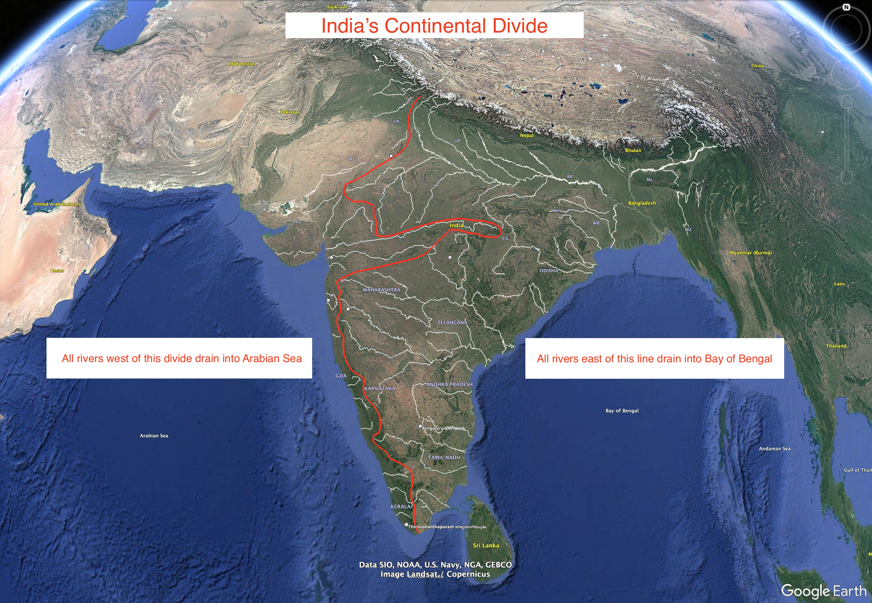
What This Map Shows
This visualization represents an approximation of India's continental divide, illustrating how the landmass is oriented and how it influences river systems across the country. Unlike the well-defined Continental Divide of the Americas, India's divide is less straightforward, showcasing a unique tilt towards the east. The map highlights how the Western Ghats play a crucial role in determining the flow of rivers in peninsular India, making it a significant geographical feature worth exploring.
Deep Dive into India's River Systems
Ever wondered why rivers in India predominantly flow towards the east? This phenomenon is largely due to the country's topography and the formidable Western Ghats. These mountain ranges, which run parallel to the western coast of India, act as a natural barrier that influences the direction of river flow.
The Western Ghats, recognized as a UNESCO World Heritage Site, rise steeply from the coastal plains and create a distinct watershed. Rivers such as the Godavari, Krishna, and Kaveri originate in these mountains, flowing eastward into the Bay of Bengal. This eastward bias is not just a geographical quirk; it plays a vital role in the ecology and agriculture of the region. For instance, the fertile plains of the Deccan Plateau benefit immensely from these rivers, supporting agriculture in states like Maharashtra, Andhra Pradesh, and Tamil Nadu.
Interestingly, the distribution of rivers in India is not uniform. While the majority flow eastward, there are notable exceptions. The Narmada and Tapi rivers, for example, flow westward, emptying into the Arabian Sea. This westward flow can be attributed to the geological history of the region, where rift valleys allowed these rivers to carve their paths against the prevailing slope of the land.
Moreover, India's river systems are vital for sustaining its population. Approximately 1.3 billion people rely on these rivers for drinking water, irrigation, and hydroelectric power. The interlinking of rivers has been a topic of discussion among policymakers as a means to manage water resources more effectively. However, this also raises concerns about ecological balance and the rights of local communities.
Regional Analysis
Analyzing the map, we can see distinct regional differences in river flow and watershed characteristics. In the northern part of India, the mighty Himalayas give rise to significant rivers such as the Ganges and Yamuna, which flow southwards and southeastwards towards the plains, eventually merging with the Ganges River system. The confluence of these rivers creates a fertile alluvial plain, one of the most densely populated areas in the world.
In contrast, the central and southern regions demonstrate a more complex hydrological pattern. The Western Ghats’ influence results in a plethora of smaller rivers that traverse through the states of Maharashtra, Goa, and Karnataka before reaching the eastern sea. Each of these rivers has a unique flow pattern, influenced by the local topography, climate, and human intervention.
Interestingly, the eastern coast of India is characterized by deltas formed by these rivers, such as the Sundarbans delta, which is one of the largest in the world. Here, the interplay of river flow and tidal action creates a unique ecosystem that is both rich in biodiversity and crucial for the livelihoods of local fishing communities.
Significance and Impact
Understanding India's continental divide and its river systems is essential for several reasons. Firstly, it informs us about the ecological dynamics of the region. The Western Ghats, for instance, not only influence water flow but also harbor diverse flora and fauna, making conservation efforts paramount.
Furthermore, with climate change leading to unpredictable rainfall patterns, the management of these river systems becomes increasingly critical. The importance of sustainable water management practices cannot be overstated, especially as urbanization and population growth place additional pressure on these vital resources.
Finally, considering the socio-economic implications, the rivers of India are a lifeline for millions. From agriculture to industry, the health of these waterways directly impacts food security and economic stability. Future projections indicate that with better management and conservation, these rivers can continue to support India's burgeoning population while preserving the environment.
In conclusion, the approximation of India's continental divide provides insightful perspectives on the country's complex hydrological systems and geography. This map not only serves as a representation of geographical features but also as a reminder of the interconnectedness of natural resources and human activity.
Visualization Details
- Published
- September 1, 2025
- Views
- 72
Comments
Loading comments...