Humidity Belt Map of America

Alex Cartwright
Senior Cartographer & GIS Specialist
Alex Cartwright is a renowned cartographer and geographic information systems specialist with over 15 years of experience in spatial analysis and data...
Geographic Analysis
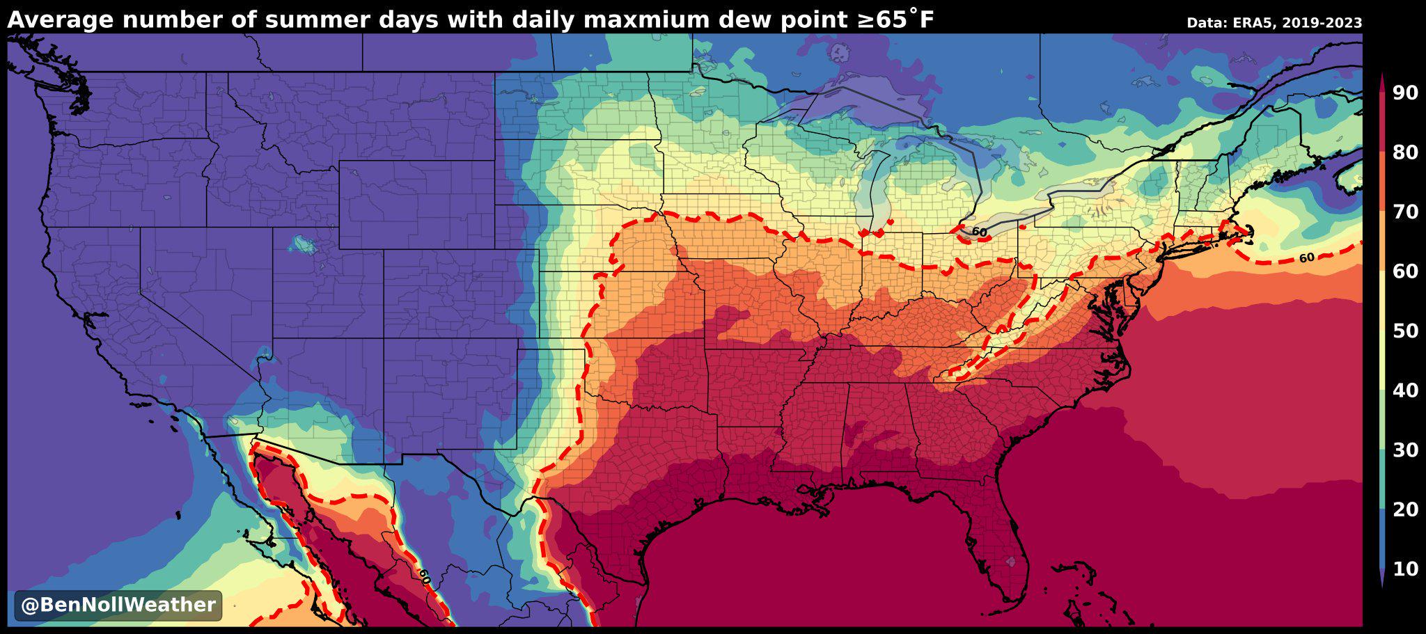
What This Map Shows
The "America's Humidity Belt" map visually represents the regions of the United States characterized by high humidity levels, showcasing areas with elevated moisture content in the atmosphere. This visualization is crucial for understanding how humidity affects weather patterns, climate-related phenomena, and even human activities across various states. It serves as a practical reference for meteorologists, climatologists, and anyone interested in the climatic nuances of the U.S.
Deep Dive into Humidity and Its Effects
Humidity is a measure of the amount of water vapor present in the air. It's an essential component of weather systems and significantly influences daily weather conditions. High humidity levels can make temperatures feel warmer than they actually are, leading to discomfort and increased heat-related health risks. Interestingly, humidity is also a key factor in precipitation patterns, as moist air can lead to cloud formation and eventual rainfall.
In the context of America's humidity belt, the southeastern states experience some of the highest moisture levels due to their geographical location and climatic conditions. For instance, areas like Florida and Louisiana often have humidity levels exceeding 90% during the summer months. This high moisture not only impacts the climate but also contributes to diverse ecosystems, including wetlands and swamps, which are crucial for biodiversity.
According to the National Oceanic and Atmospheric Administration (NOAA), humidity levels in the southeastern U.S. can be attributed to several factors, including proximity to the Gulf of Mexico, prevailing winds, and regional topography. The resulting weather patterns can lead to increased occurrences of thunderstorms, hurricanes, and tornadoes, particularly during the summer and fall. Moreover, high humidity can exacerbate the effects of heatwaves, posing significant health risks for vulnerable populations.
Interestingly, while the southeastern states dominate the humidity landscape, other regions in the U.S. also experience notable humidity levels. For example, the Midwest can see high humidity during the summer months, particularly in states like Illinois and Indiana, where the combination of agriculture and atmospheric conditions creates a humid microclimate.
Regional Analysis
When examining the humidity belt across the United States, it's essential to break it down regionally. The southeastern U.S. typically experiences the highest average humidity, particularly from June through August. States such as Florida, Alabama, Mississippi, and Louisiana consistently record some of the highest humidity percentages, often resulting in discomfort and heat advisories during the summer.
In contrast, the northeastern U.S. also experiences significant humidity, especially in coastal areas like New Jersey and New York. However, the intensity and duration of humidity spikes can differ greatly from the South. For example, while New York City may experience high humidity levels, the duration is often shorter compared to states in the Deep South.
Midwestern states like Missouri and Indiana can also see humidity levels rise during the summer months, but the overall climate feels less oppressive than in the Southeast. This variation can be attributed to different wind patterns and geographical features that influence local climates. Interestingly, the Pacific Northwest, known for its temperate climate, experiences lower humidity levels, particularly during the summer months, due to its unique coastal weather patterns.
Significance and Impact
Understanding America's humidity belt is crucial for several reasons. First, it provides insights into agricultural practices, as humidity directly affects crop growth and irrigation needs. Farmers in high-humidity regions must adapt their methods to ensure optimal yields, particularly for crops sensitive to moisture levels.
Moreover, high humidity can have significant health implications. It plays a role in the spread of certain illnesses, as humidity can encourage the proliferation of mold and other allergens. Communities in high-humidity areas must be proactive in addressing these health risks, particularly during the summer months when heat and humidity peak.
As climate change continues to influence weather patterns across the globe, understanding the dynamics of humidity in the U.S. will become increasingly important. Projections indicate that certain areas may experience shifts in humidity levels, impacting everything from agriculture to urban planning. Have you noticed how weather forecasts often highlight humidity levels? This focus is not just a trivial detail; it can significantly impact our daily lives, from what we wear to how we plan outdoor activities.
In conclusion, the "America's Humidity Belt" map serves as an essential tool for understanding the complexities of climate in the U.S. The implications of humidity reach far beyond mere discomfort; they influence ecological systems, economic activities, and public health. As we move forward, a deeper understanding of these factors will be vital in adapting to the changing climate and its challenges.
Visualization Details
- Published
- August 31, 2025
- Views
- 78
Comments
Loading comments...