Physical Map of Ireland

David Chen
Data Visualization Specialist
David Chen is an expert in transforming complex geographic datasets into compelling visual narratives. He combines his background in computer science ...
Geographic Analysis
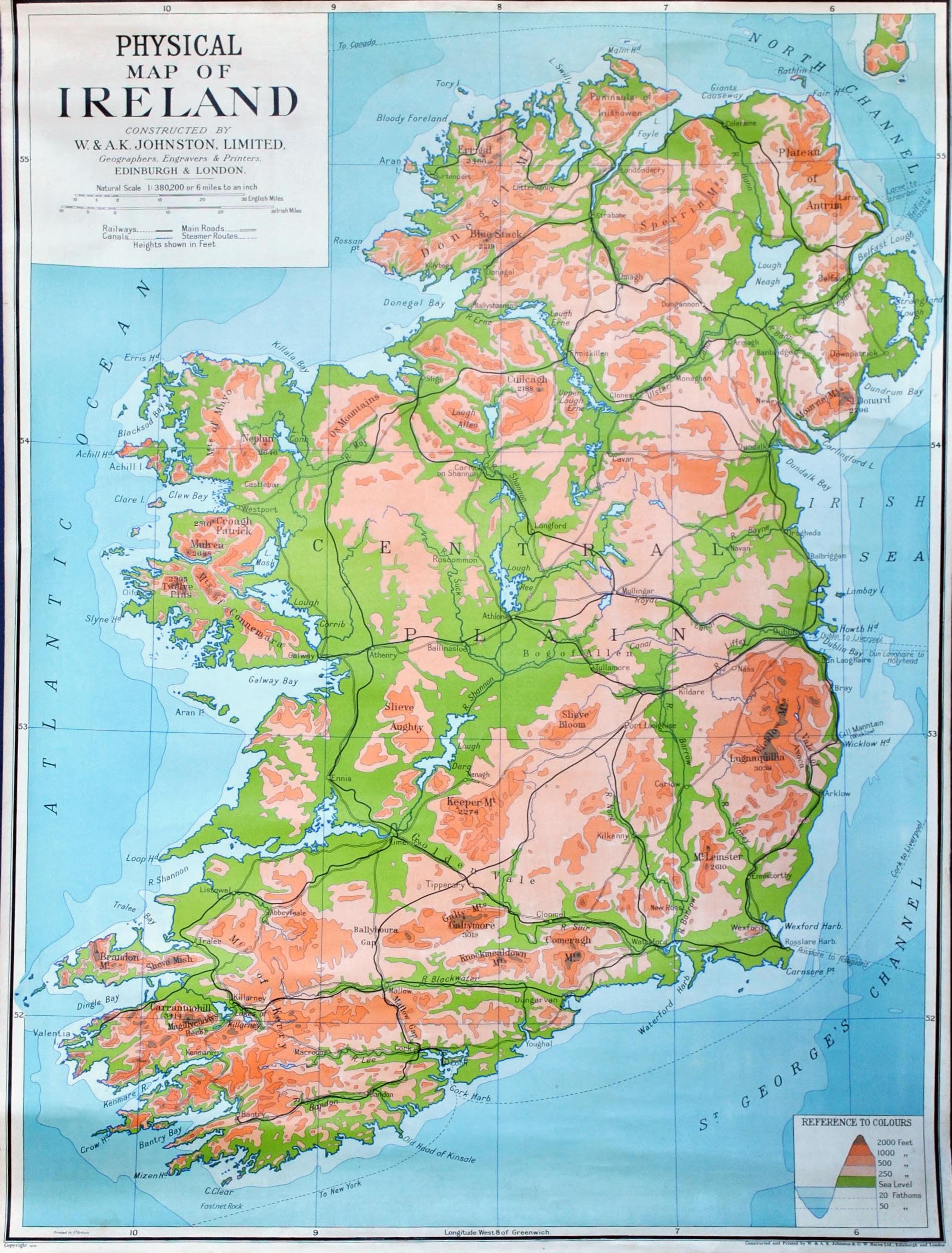
What This Map Shows\nThe physical map of Ireland provides a detailed representation of the country's diverse landscapes. It highlights key geographical features such as mountains, rivers, lakes, and coastlines, offering a clear view of the terrain that shapes Ireland’s natural beauty and climate. This visualization allows us to appreciate the intricate details of the Emerald Isle's geography, from its rugged cliffs to its rolling hills and expansive waters.
Deep Dive into Ireland's Geography\nIreland is renowned for its stunning landscapes, characterized by a variety of physical features that include mountains, plains, and numerous waterways. The island is divided into two main regions: Northern Ireland, which is part of the United Kingdom, and the Republic of Ireland. The highest peak in Ireland is Carrauntoohil, standing at 1,038 meters (3,406 feet), located in the Macgillycuddy's Reeks mountain range in County Kerry. What's fascinating is how these mountains influence local weather patterns, contributing to the lush, green scenery that Ireland is famous for.
The country’s rivers, such as the River Shannon—the longest river in Ireland—play a crucial role in both the ecology and economy. Stretching approximately 360 kilometers (224 miles), the Shannon is a vital waterway for transport and recreation. It flows from Lough Allen in the North to the Atlantic Ocean, traversing various landscapes and providing habitats for numerous species of fish and birds.
Interestingly, Ireland's topography is also shaped by its extensive limestone features, particularly in the Burren region of County Clare. This unique karst landscape is known for its stark beauty and biodiversity, including a mix of Mediterranean and Arctic plants that thrive in this unusual environment. Ireland's position in the North Atlantic also contributes to its temperate maritime climate, with mild winters and cool summers, influencing the agricultural practices that are integral to its economy.
Regional Analysis\nWhen examining Ireland's geography by region, we notice stark contrasts. For instance, the rugged coastline of the West, characterized by dramatic cliffs and deep bays, contrasts sharply with the more gentle hills and valleys of the East. The Wild Atlantic Way, a scenic coastal route, showcases the breathtaking views of the western shores, where the Atlantic Ocean meets steep cliffs, notably at locations like the Cliffs of Moher.
In contrast, the central part of Ireland, particularly the Midlands, is known for its flat plains that are ideal for agriculture. This area is less hilly and is characterized by many bogs, which have historically played a significant role in the country's economy, particularly in the production of peat.
Moreover, Northern Ireland features its own unique geographical features, including the famous Giant's Causeway, an area of about 40,000 interlocking basalt columns resulting from ancient volcanic activity. This UNESCO World Heritage Site attracts numerous tourists each year, contributing to the region's economy and cultural significance.
Significance and Impact\nUnderstanding Ireland's physical geography is crucial for several reasons. Firstly, it provides insight into the country’s natural resources, which are vital for the agricultural sector, tourism, and energy production. The rich soils of the plains support robust farming, while the coastal areas offer fishing opportunities and a gateway for trade.
Furthermore, as climate change becomes a pressing global issue, Ireland's geography highlights vulnerabilities and opportunities for adaptation. For instance, rising sea levels threaten coastal communities, while changing weather patterns may impact agricultural yields. The Irish government and local communities are increasingly focusing on sustainable practices to mitigate these effects, emphasizing the importance of understanding physical geography in planning for the future.
In conclusion, Ireland’s physical map doesn't just depict landforms; it tells a story of how geography shapes life, culture, and the economy on the island. Whether you're a resident or a visitor, appreciating these geographical features enhances our understanding of this beautiful country and the challenges it faces as we move forward in a changing world.
Visualization Details
- Published
- August 31, 2025
- Views
- 72
Comments
Loading comments...