Map of North and Central Italy in 1500

Marcus Rodriguez
Historical Geography Expert
Marcus Rodriguez specializes in historical cartography and geographic data analysis. With a background in both history and geography, he brings unique...
Geographic Analysis
What This Map Shows
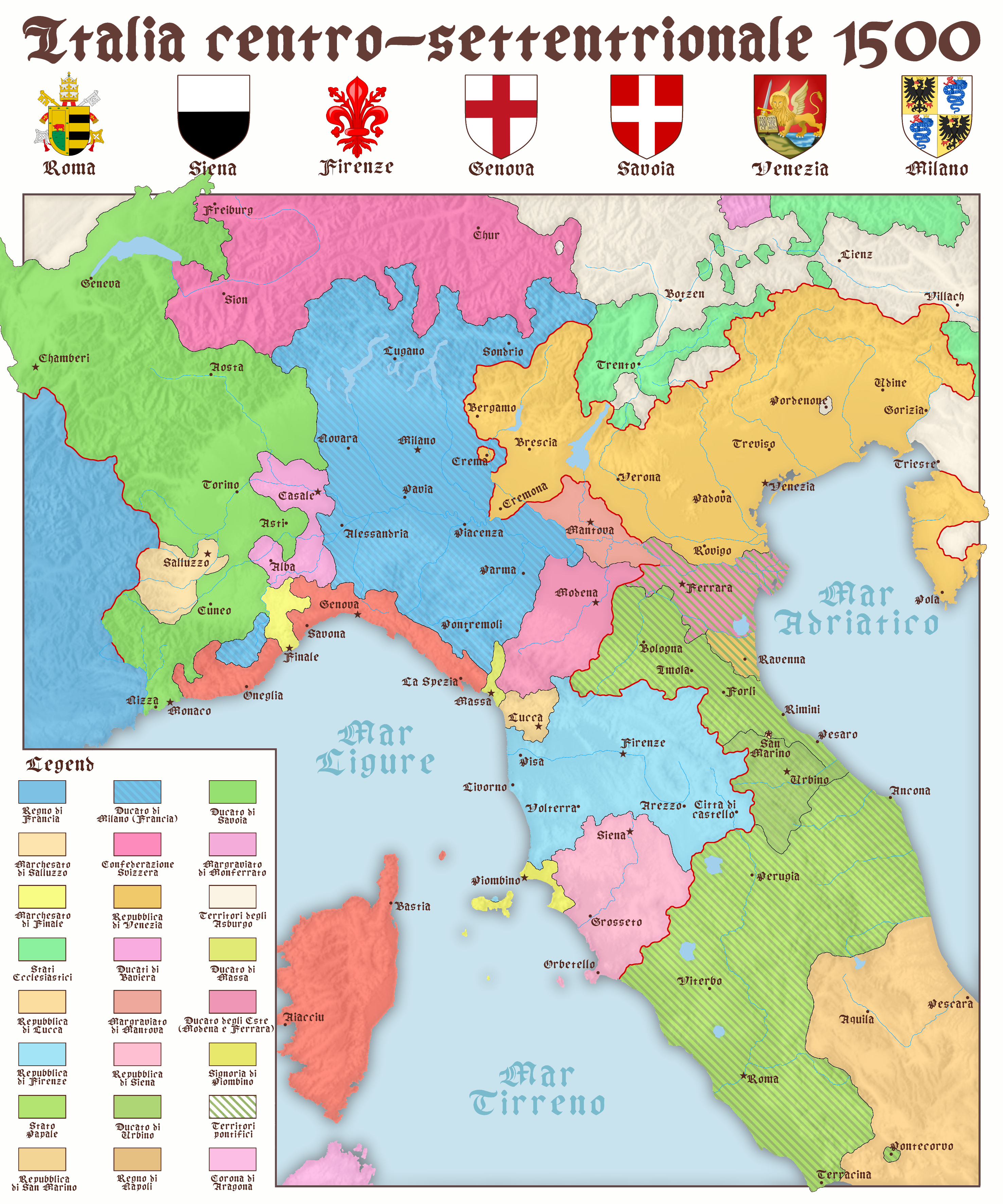
The map titled "North and Center Italy in 1500" provides a detailed snapshot of the geographical and political landscape of Italy during the early Renaissance. It illustrates the various city-states, territories, and regions that defined this vibrant period in Italian history. From the bustling trade hubs of Venice and Florence to the Papal States centered around Rome, this map serves as a fascinating portal into a time when Italy was not a unified nation but a collection of politically independent entities.
What’s particularly striking about this map is how it encapsulates not just the boundaries of these regions but also hints at the economic, cultural, and social dynamics at play. The map showcases major rivers, roads, and coastal areas, highlighting the importance of trade routes that facilitated commerce and communication among these diverse territories.
Deep Dive into the Political Landscape of 1500
During the year 1500, Italy was a patchwork of city-states, each with its own government, economy, and culture. The political fragmentation was significant, with powerful states like the Republic of Venice, the Duchy of Milan, and the Kingdom of Naples vying for influence. This division had profound implications on trade, military strategy, and cultural development.
Interestingly, Venice, situated on the Adriatic Sea, was one of the most powerful maritime republics of the time. Its extensive trade networks stretched as far as the East, bringing in spices, silks, and other exotic goods. The city’s wealth allowed it to invest heavily in art and architecture, leading to a flourishing of culture that is still celebrated today.
On the other hand, Florence was the cradle of the Renaissance, home to influential figures like Leonardo da Vinci and Michelangelo. The Medici family, who ruled Florence, were great patrons of the arts, and their influence can be seen in the stunning artworks and architectural marvels that emerged during this period. The map highlights Florence's strategic location along important trade routes, which facilitated its growth into a cultural powerhouse.
Meanwhile, the Papal States, centered around Rome, held significant religious and political power. The presence of the Pope made this region a focal point for the Catholic faith and a center of political intrigue. The map illustrates how the Papal States were surrounded by rival territories, making their political maneuvering crucial.
Additionally, the Kingdom of Naples emerged as a significant player in southern Italy, often caught in conflicts between regional powers. The map provides insight into the complex relationships and rivalries that characterized the time.
Regional Analysis
When examining the regions depicted in the map, notable differences emerge. Northern Italy, for example, was marked by economic prosperity and urbanization. Cities like Milan and Venice were not just political entities; they were also centers of innovation and trade. Milan, with its strong fortifications and strategic location, became a military hub, while Venice thrived as a center of commerce.
Conversely, central Italy, dominated by the Papal States and Tuscany, presented a different picture. This area was less about trade and more focused on cultural and religious significance. The flourishing of the arts in Florence and the political machinations of the Papacy influenced not just the region but the entire European landscape.
Interestingly, southern Italy, including the Kingdom of Naples, faced challenges that were less pronounced in the north. Political instability and foreign invasions characterized this area, impacting local economies and governance. The map highlights territorial disputes and shifting allegiances that defined southern Italy's experience during this time.
Significance and Impact
Understanding the geographical and political landscape of Italy in 1500 is crucial for comprehending the broader narrative of European history. The fragmentation of Italy laid the groundwork for the eventual unification of the country in the 19th century. The interactions among these city-states fostered a spirit of competition and innovation that led to artistic and scientific advancements still revered today.
Furthermore, the map reveals how trade routes established in this period shaped future economic systems. The connections forged among these regions facilitated the exchange of ideas and goods, setting the stage for the Age of Exploration and the eventual globalization of trade.
In contemporary times, the cultural and historical legacies of these city-states continue to influence Italy’s identity. The Renaissance’s impact on art, science, and politics remains deeply ingrained in Italian culture and is a vital component of its global reputation.
In summary, the map of North and Central Italy in 1500 is more than just a historical artifact; it is a testament to the complex interplay of politics, culture, and geography that shaped not only Italy but also the entire European continent during a pivotal era.
Visualization Details
- Published
- August 30, 2025
- Views
- 106
Comments
Loading comments...