Elevation Map of the Alps

David Chen
Data Visualization Specialist
David Chen is an expert in transforming complex geographic datasets into compelling visual narratives. He combines his background in computer science ...
Geographic Analysis
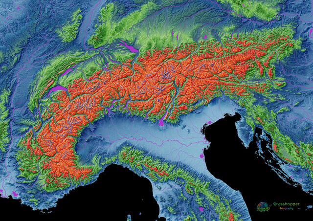
What This Map Shows
The elevation map of the Alps provides a stunning visual representation of the mountain range's topography, showcasing the varying heights that contribute to its dramatic landscape. The Alps are not just any mountains; they are a complex system that has shaped the climate, culture, and economies of the surrounding regions. This map highlights elevations ranging from the majestic heights of Mont Blanc, the highest peak at 4,808 meters (15,774 feet), to the lower valleys that cradle charming alpine villages. Understanding these elevations is crucial for appreciating how they influence everything from weather patterns to tourism.
Deep Dive into Alpine Elevation
The Alps are a formidable barrier in Europe, stretching across eight countries: France, Switzerland, Italy, Germany, Austria, Slovenia, Monaco, and Liechtenstein. The average elevation of the Alps is around 2,500 meters (8,200 feet), with the highest peaks characterized by rugged terrain and glacial features. Interestingly, many of these peaks are not just geological wonders; they play a significant role in regulating weather patterns across Europe.
Elevation plays a critical role in climate, and the Alps are no exception. The orographic effect, where moist air rises over the mountains, leads to increased precipitation on the windward side, while the leeward side often experiences drier conditions. This phenomenon can be observed in the difference between the lush, green valleys of the northern slopes and the more arid southern regions, such as the Italian side of the Alps.
Moreover, the elevation of the Alps has a direct impact on the biodiversity found in the region. As we ascend, we encounter distinct ecological zones. Lower elevations are home to deciduous forests, while higher altitudes transition into coniferous forests, and eventually reach the alpine tundra at the highest altitudes. This stratification creates unique habitats for a variety of flora and fauna, some of which are endemic to this region.
Climate change is also a significant concern in the Alps. Glaciers are retreating rapidly, with estimates suggesting a loss of up to 70% of glacial mass by the end of the century if current trends continue. This not only affects the stunning landscapes but also has serious implications for water supply, as many rivers in Europe are fed by meltwater from these glaciers.
Regional Analysis
Breaking down the elevation map by regions reveals fascinating contrasts. In the western Alps, particularly in France, peaks like Mont Blanc dominate the skyline, attracting climbers and tourists alike. The area is not only known for its elevation but also for its rich cultural history, with numerous alpine traditions and winter sports that have become integral to local economies.
In contrast, the central Alps, particularly in Switzerland, are characterized by a unique combination of high peaks and deep valleys. The elevation here supports a thriving ski industry, with resorts like Zermatt and St. Moritz drawing visitors from around the globe. Interestingly, this region is also known for its intricate network of hiking trails that allow for immersive experiences in nature.
Meanwhile, the eastern Alps, particularly in Austria, showcase a blend of natural beauty and cultural heritage. Here, the elevation is slightly lower, but the dramatic scenery remains breathtaking. The valleys are dotted with quaint villages, and the region is renowned for its historic architecture and traditional alpine festivals.
Significance and Impact
Understanding the elevation of the Alps is critical for numerous reasons. Firstly, it plays a crucial role in water management; rivers originating in the Alps, such as the Rhône, Rhine, and Danube, are vital for millions of people across Europe. The health of these waterways is directly linked to the climatic conditions and snowmelt patterns influenced by elevation.
Moreover, the Alps are a major tourist destination, with millions flocking to enjoy skiing, hiking, and the breathtaking scenery each year. This influx of tourism significantly impacts local economies, providing jobs and supporting businesses. However, as climate change threatens the stability of the alpine environment, tourism is also at risk, which raises concerns about sustainability in these beautiful but fragile landscapes.
In conclusion, the elevation map of the Alps is not just a depiction of heights; it encapsulates a region rich in biodiversity, cultural significance, and environmental challenges. Ever wondered how these majestic mountains influence life in Europe? The answers lie in the intricate interplay between elevation, climate, and human activity, making the Alps a fascinating subject of study for geographers and enthusiasts alike.
Visualization Details
- Published
- August 29, 2025
- Views
- 90
Comments
Loading comments...