Simplified Map of Europe in the 16th Century

Marcus Rodriguez
Historical Geography Expert
Marcus Rodriguez specializes in historical cartography and geographic data analysis. With a background in both history and geography, he brings unique...
Geographic Analysis
What This Map Shows
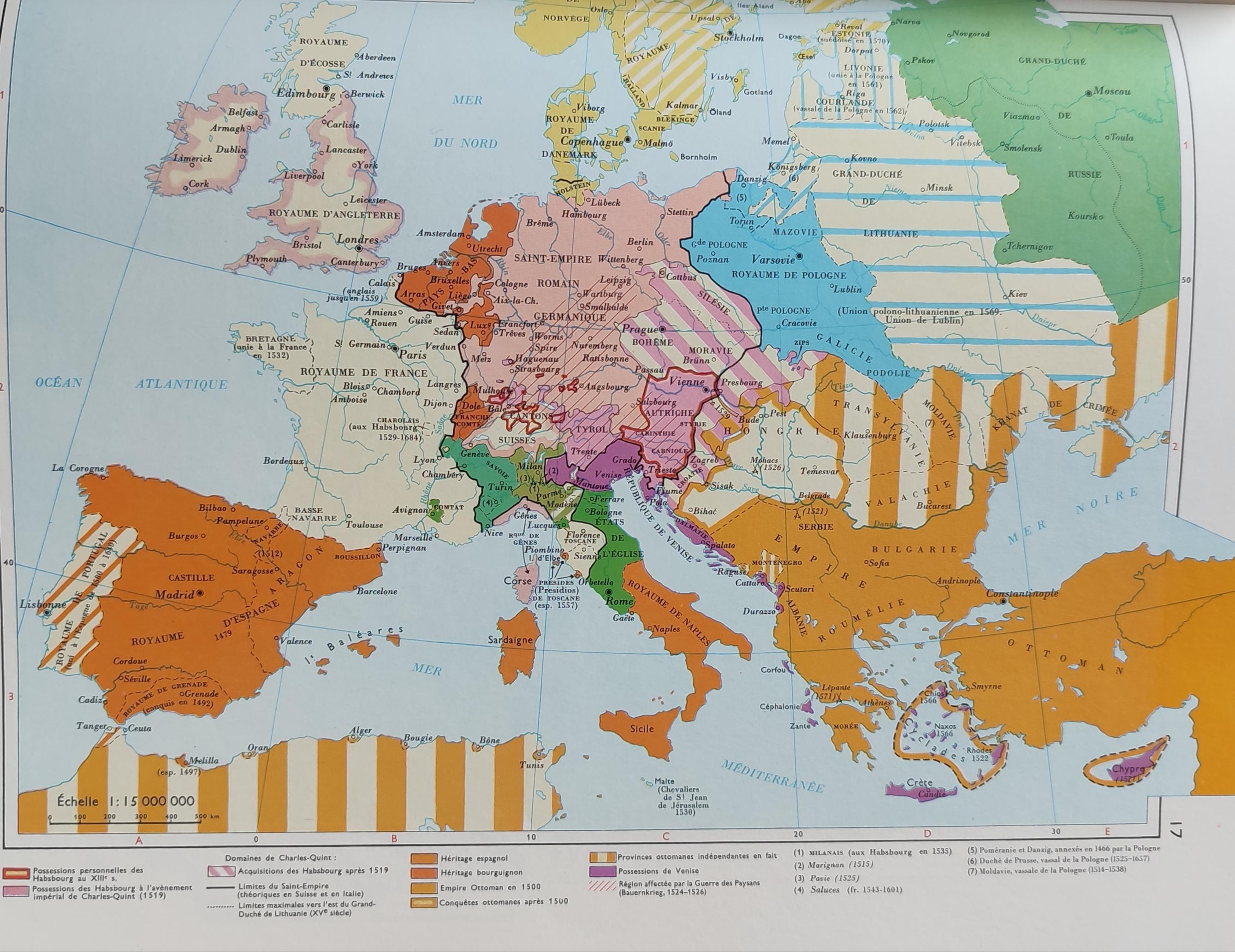
The 'Very Simplified Map of Europe in the 16th Century' presents a bird's-eye view of a continent in the midst of profound transformation. At this time, Europe was not just a patchwork of territories but a dynamic stage for political intrigue, economic expansion, and cultural exchange. This map highlights the key regions and political boundaries of the era, providing a glimpse into how European nations were defined during a time of exploration and conflict.
Deep Dive into Political Boundaries and Territories
The 16th century was marked by the rise and fall of empires and the establishment of nation-states. This period saw the beginnings of modern nationhood, with countries like Spain, France, and England solidifying their territories. Interestingly, the Peace of Westphalia, which later shaped the modern state system, had not yet occurred, meaning that borders were often fluid and contested.
One of the most significant political entities of this time was the Spanish Empire, which was at the height of its power. Spain's vast territories included not only the Iberian Peninsula but also colonies in the Americas, making it one of the first global empires. The map reflects Spain's prominence, with its borders extending to parts of Italy and the Netherlands, regions it sought to control.
On the other hand, France was emerging as a powerful nation under the rule of King Francis I. The map illustrates France's ambitions, showcasing its territorial disputes with Spain and the Habsburgs, which were critical to the power dynamics of Europe. Notably, the Habsburg Empire itself was a vast collection of territories that included present-day Austria, Hungary, and parts of Italy and Spain, highlighting the complexity of political affiliations of the time.
Moreover, the map indicates the influence of the Ottoman Empire, which was making inroads into Eastern Europe. By the 16th century, the Ottomans had conquered much of the Balkan Peninsula, and their presence was a significant factor in European politics, leading to conflicts that would last for centuries. The Ottomans were not just a military power; they influenced trade routes and cultural exchange, impacting the regions they touched.
Regional Analysis
Breaking down the map by regions offers a clearer understanding of the political landscape of 16th-century Europe. In the West, France and Spain were primary players, often engaged in territorial battles. For instance, the ongoing conflict over Naples illustrates the fierce competition between these two powers. France's claim to Naples was rooted in dynastic ties, while Spain's control was bolstered by military might.
Moving to Central Europe, the Habsburgs had a remarkable grip on territories that spanned from the Alps to the Baltic Sea. Their lands included not only Austria but also parts of modern-day Czech Republic and Slovakia. This region was characterized by a diverse population and a complex web of loyalties and rivalries, which often led to internal strife.
In Eastern Europe, the Ottoman Empire's expansion introduced a different dynamic. Regions like Hungary and Transylvania were battlegrounds between Christian states and the Muslim Ottoman forces. Interestingly, these conflicts were not just military in nature; they involved significant cultural exchanges, as the Ottomans brought new ideas and practices to the territories they conquered.
Significance and Impact
Understanding the political landscape of 16th-century Europe is crucial because it set the stage for many modern nation-states and conflicts. The boundaries established during this period influenced not only territorial claims but also cultural identities that persist today. For example, the rivalry between France and England during this time laid the groundwork for future conflicts, including the Hundred Years' War.
Moreover, the exploration and colonization that began in this era led to global interactions that transformed economies and societies worldwide. The wealth generated from colonies fueled European powers and initiated trade networks that would connect continents. However, this also came at a significant cost, often resulting in the exploitation and displacement of indigenous populations.
In contemporary discussions, the legacies of these historical boundaries are still visible. Nationalism, borders, and cultural identities are issues that continue to shape Europe and its interactions with the rest of the world. As we look forward, understanding this historical context allows us to navigate current geopolitical challenges more effectively.
The 16th century was indeed a pivotal moment in European history, and this map serves as a window into a complex and dynamic period that has left an indelible mark on the continent's geography and identity.
Visualization Details
- Published
- August 27, 2025
- Views
- 92
Comments
Loading comments...