Coca-Growing Regions and River Routes Map

David Chen
Data Visualization Specialist
David Chen is an expert in transforming complex geographic datasets into compelling visual narratives. He combines his background in computer science ...
Geographic Analysis
What This Map Shows
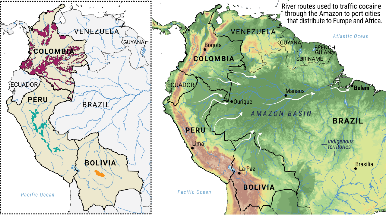
The visualization titled "Known South American coca-growing regions and the river routes they transport on" provides a detailed overview of the primary areas in South America where coca plants are cultivated, alongside the river systems that facilitate the transportation of coca products. This map, developed through collaborative efforts by the UNODC, Amazonia2030, and Scientific Reports, highlights not only the geographical distribution of coca cultivation but also the intricate networks of waterways used in this industry.
Rivers have always been vital arteries for trade and transportation in South America, and understanding their role in the coca trade offers insights into both the region's geography and its socio-economic challenges.
Deep Dive into Coca Cultivation and River Systems
Coca plants, primarily cultivated for the production of cocaine, thrive in specific climatic and geographical conditions found in the Andean region of South America. Countries like Colombia, Peru, and Bolivia are the epicenters of coca cultivation, where the tropical climate, rich soil, and elevation create an ideal environment for these plants. In 2021, the UNODC reported that Colombia alone accounted for approximately 70% of the global coca production, highlighting the scale of this issue.
Interestingly, the cultivation of coca is often interwoven with local agricultural practices. Farmers may grow coca alongside other crops, which can create complex economic dependencies. This interdependence is critical for understanding the socio-economic dynamics in these regions. What's fascinating is that while coca is often viewed solely through the lens of drug production, it also plays a significant role in the livelihoods of many rural communities, who rely on it as a cash crop.
Rivers such as the Amazon, Putumayo, and Huallaga serve as essential routes for transporting coca products. The Amazon River, for instance, meanders through vast landscapes, providing access to remote areas where coca is cultivated. These waterways not only facilitate the movement of coca but also impact the broader ecological systems in the region. The hydrological networks in South America are complex, comprising tributaries and smaller streams that feed into larger rivers, creating a comprehensive system of transport that is crucial for the coca trade.
Moreover, the flow patterns of these rivers often dictate the logistics of coca transport. For example, the seasonal variations in river levels can significantly influence the ease of access to coca-growing regions. During the rainy season, swollen rivers can provide better access, while the dry season may hinder transportation, forcing farmers and traffickers to adapt their strategies.
Regional Analysis
Breaking down the coca-growing regions on the map reveals distinct patterns across different countries. In Colombia, the Sierra Nevada de Santa Marta and the Catatumbo region are notable for their high coca yields. The geographic isolation of these areas, combined with the proximity to river routes, facilitates both cultivation and transport. In contrast, Peru's coca-growing regions, particularly around the Upper Huallaga Valley, benefit from a different set of ecological conditions and supply chains.
Interestingly, Bolivia presents a unique case where coca cultivation is legally recognized for traditional uses, such as in the production of coca tea. The Yungas and Chapare regions are primarily known for their coca production, which, unlike in Colombia and Peru, exists within a legal framework. This legal status creates an intriguing juxtaposition with the illegal trafficking that occurs in neighboring countries.
Significance and Impact
Understanding the geography of coca cultivation and its transportation routes is crucial for several reasons. Firstly, it sheds light on the economic realities faced by farmers in these regions. The reliance on coca as a cash crop can perpetuate cycles of poverty and violence, particularly as drug trafficking organizations vie for control over lucrative trade routes. Additionally, the environmental implications of coca cultivation are significant, with deforestation and biodiversity loss often associated with expanding coca farms.
As the global demand for cocaine continues to fluctuate, so too will the dynamics of coca cultivation and its transportation networks. Current trends indicate a growing focus on addressing the root causes of coca cultivation through alternative development strategies. However, the challenge remains complex, as efforts to eradicate coca often overlook the socio-economic factors at play.
In conclusion, the coca-growing regions and their associated river routes present a multifaceted issue that intertwines geography, economy, and environmental concerns. By examining this map, we gain a clearer understanding of how these elements interact, shaping the lives of those involved in the coca trade and the broader implications for South America.
Visualization Details
- Published
- August 23, 2025
- Views
- 100
Comments
Loading comments...