Poland and Lithuania Historical Map 1370-1505

Alex Cartwright
Senior Cartographer & GIS Specialist
Alex Cartwright is a renowned cartographer and geographic information systems specialist with over 15 years of experience in spatial analysis and data...
Geographic Analysis
What This Map Shows
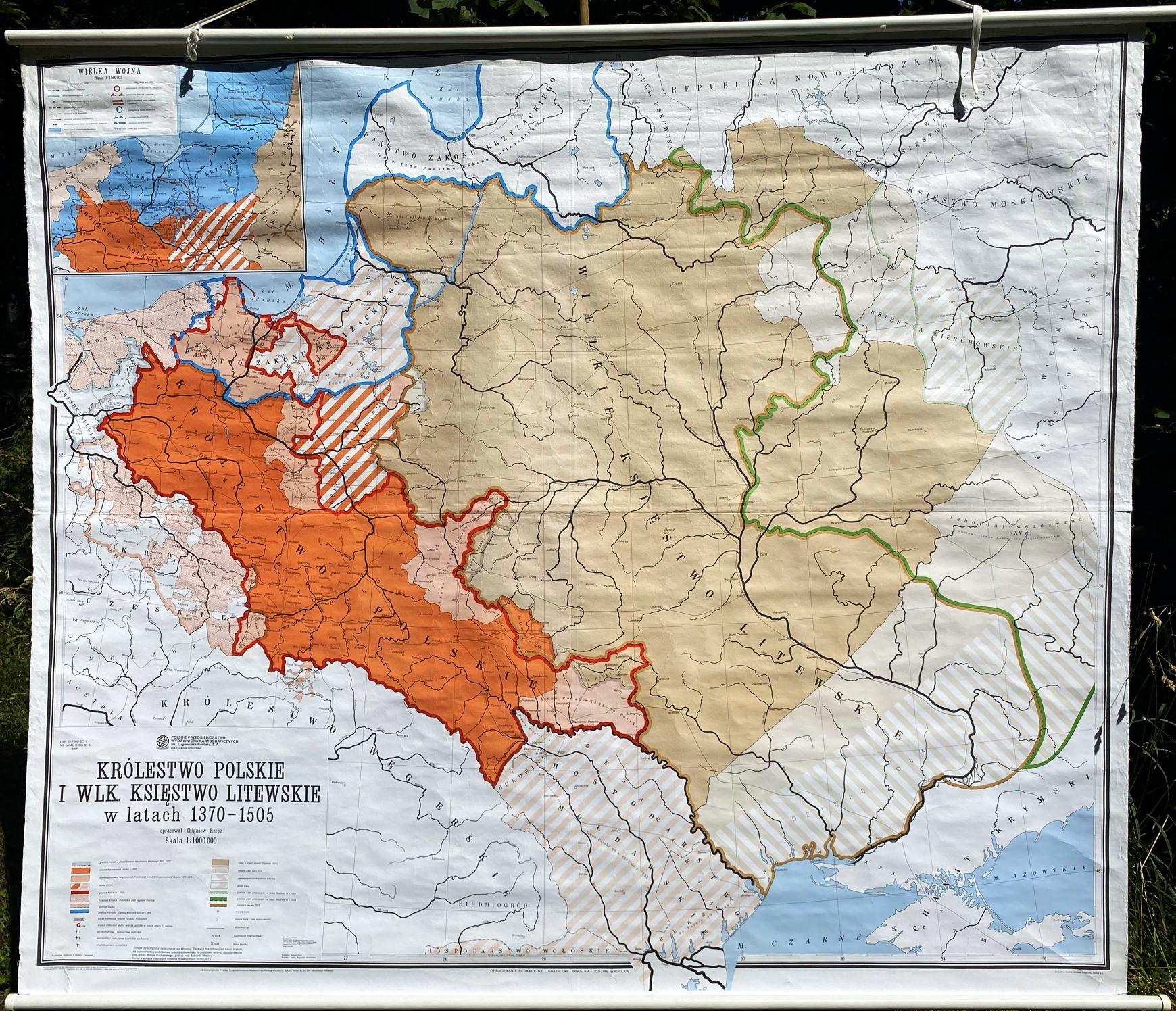
This vintage school map illustrates the territorial expanse of Poland and Lithuania during the years 1370 to 1505, a time marked by significant political, cultural, and social transformations for both nations. The map highlights the borders and key cities of the two countries, providing a visual context for understanding their historical interactions, alliances, and conflicts. This period is particularly crucial as it saw the rise of the Polish-Lithuanian Commonwealth, which would become one of the largest and most influential states in Europe.
Deep Dive into the Polish-Lithuanian Commonwealth
The era represented in this map is pivotal in European history, as it marks the formation of the Polish-Lithuanian Commonwealth in 1569, though its roots trace back to earlier alliances. The marriage between Queen Jadwiga of Poland and Grand Duke Władysław II Jagiełło of Lithuania in 1386 initiated a powerful political union that significantly shaped the geopolitical landscape of Eastern Europe.
During this time, the territories of Poland and Lithuania were characterized by a complex tapestry of ethnic groups and cultures. Poland primarily consisted of Polish-speaking inhabitants, while Lithuania was home to a diverse population, including Lithuanians, Ruthenians, and Poles. This mixture fostered a rich cultural exchange that has left a lasting legacy on the region.
Interestingly, the map also indicates the significant role of the Teutonic Knights, a military order that posed a considerable threat to both nations. Their presence in the region led to several key conflicts, notably the Battle of Grunwald in 1410, which is often viewed as a turning point that diminished the Knights' power and bolstered Polish-Lithuanian dominance.
Economically, this period was marked by agricultural expansion and the growth of trade routes, particularly along the Vistula River, which became a vital artery for commerce. The flourishing of cities such as Kraków and Vilnius during this time highlights the urban development that accompanied the political changes. Kraków, as the capital of Poland, became a cultural hub, while Vilnius served as a significant center for Lithuanian governance and culture.
Regional Analysis
Examining the map closely, one can observe distinct regional characteristics within Poland and Lithuania. For instance, the southern regions of Poland, particularly around Silesia, were known for their fertile land and agricultural output, contributing significantly to the economy. In contrast, the northern regions, especially near the Baltic Sea, were more influenced by trade and maritime activities.
Lithuania, on the other hand, had vast forests and natural resources, which played a crucial role in its economy. The Grand Duchy of Lithuania extended far into present-day Belarus and Ukraine, showcasing its historical significance and the diverse demographics within these regions. The interplay between Polish and Lithuanian territories was not merely political but also cultural, as the two nations influenced each other's languages, traditions, and societal structures.
Significance and Impact
Understanding the historical geography of Poland and Lithuania during 1370 to 1505 allows us to appreciate the formation of national identities and their implications for modern Europe. The legacy of the Polish-Lithuanian Commonwealth is evident today, as both nations continue to navigate their historical narratives in the context of European unity and cooperation.
Moreover, recognizing the shifting borders and cultural exchanges of this period sheds light on contemporary issues such as regional identity, minority rights, and the importance of historical memory in shaping current political landscapes. The historical ties between Poland and Lithuania are still celebrated today, particularly through initiatives aimed at fostering bilateral relations and cultural heritage.
As we look to the future, understanding this historical map serves as a reminder of the intricate web of alliances, conflicts, and cultural exchanges that have shaped not only Poland and Lithuania but also the broader European context. The past informs the present, and as these nations continue to evolve, the lessons learned from their shared history remain vital in navigating modern challenges.
Visualization Details
- Published
- August 21, 2025
- Views
- 90
Comments
Loading comments...